
Jamestown and Geodiscovery
Jamestown Island is a low patch of ground in southeastern Virginia that’s witnessed its share of American history. Settler colonists arrived from England in 1607 and sited their fort/town on the island ~40 miles (65 km) upstream from the mouth of the Chesapeake Bay. It’s a foundational location in the American origin narrative – for some it’s the birthplace of democracy, yet it’s also the place that enabled slavery to take root and grow in North America.
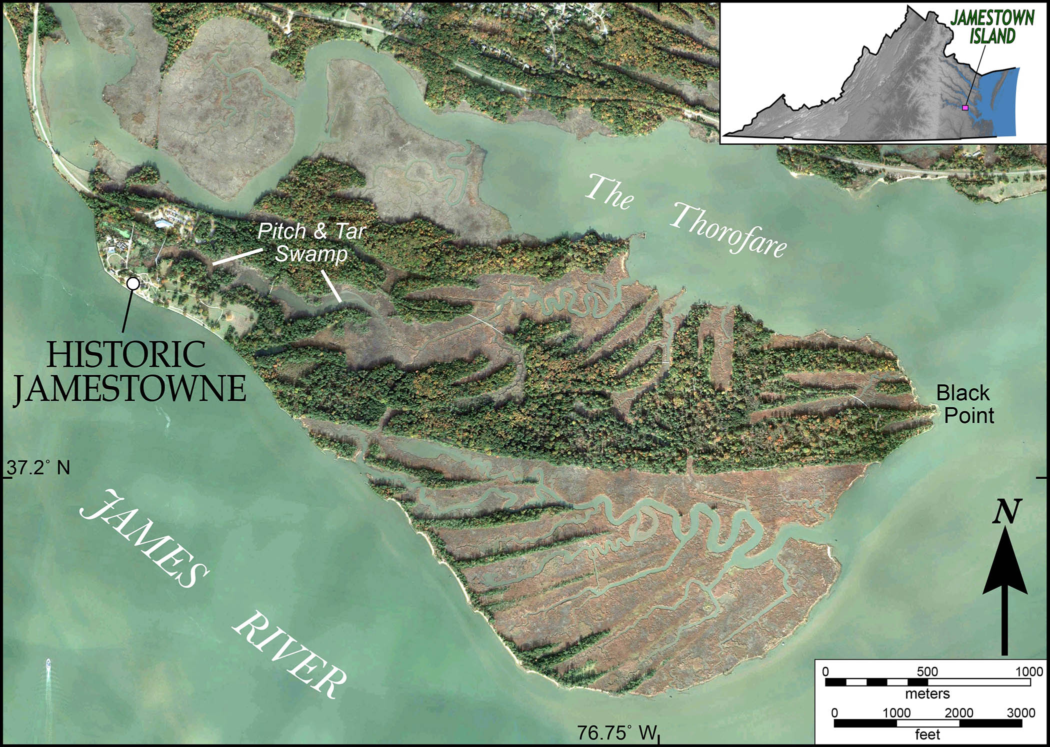
Imagery of Jamestown Island, Virginia. The island consists primarily of marsh and forest. Historic Jamestowne is the site of the 1607 colonialization by English settlers. The James River and its surrounding waters are estuaries influenced by tides and its waters are brackish.
Today, the U.S. National Park Service manages Jamestown Island, but Preservation Virginia, a foundation dedicated to both saving and curating historic sites across the Commonwealth, owns the original fort and historic church. The team of Preservation Virginia archaeologists and forensic scientists at the Jamestown Rediscovery Project continue to chronicle dramatic events from the early 17th century.
But at Jamestown Island, it’s the next hundred years that will bring more landscape and environmental change than the cumulative total of the proceeding four centuries. Jamestown Island, and its cultural resources – not just of the colonial British settlers, but also the record of First Nations and other marginalized communities on the periphery of early 17th century Jamestown – are critically threatened.
Jamestown Island occupies ~1,500 acres (~6 km2) on the northside of the James River, it’s separated from the mainland by the narrow Back River and the Thorofare. More than half of Jamestown Island is covered by marsh and swampy wetlands. On the shaded relief map below, notice that much of Jamestown Island is low country, with lots of terrain at or below 2’ (0.6 m) above sea level. The highest natural terrain on the island are distinctive ‘ridges’ that top out 12 to 15 feet (3.6 to 4.5 m) above sea level.
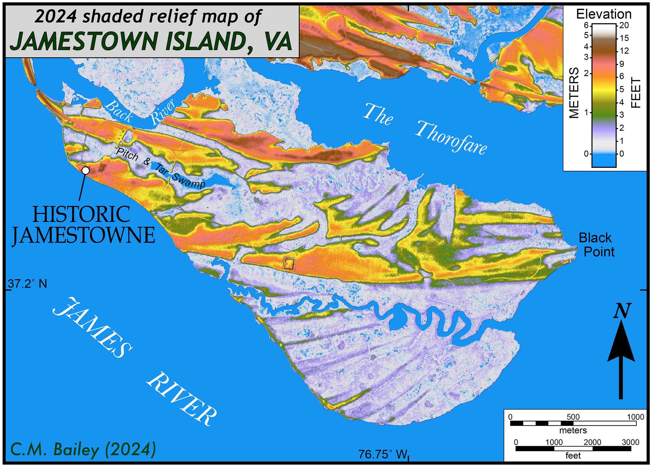
Shaded relief map of Jamestown Island, Virginia based on LiDAR elevation data. Note the exceptional low elevations for much of the island as well as the arcuate ridge complexes.
Jamestown Island has a subtle stair-stepped landscape that’s characterized by sets of ridges and swales. The arcuate low ridges are underlain by silty sand and forested, while the low swales form mucky wetlands.
But just how do these ridges and swales actually form?
From the present to the future
For me, Black Point at the far eastern end of the island is a dramatic locale. Here the water meets the land, and the vista across the wide James River ranges from sublime to fabulous. As late as the 1980s there was a U.S. Geological Survey (USGS) benchmark located on dry land at Black Point, yet by the early 2000s the marker was partially submerged, and clearly going under.
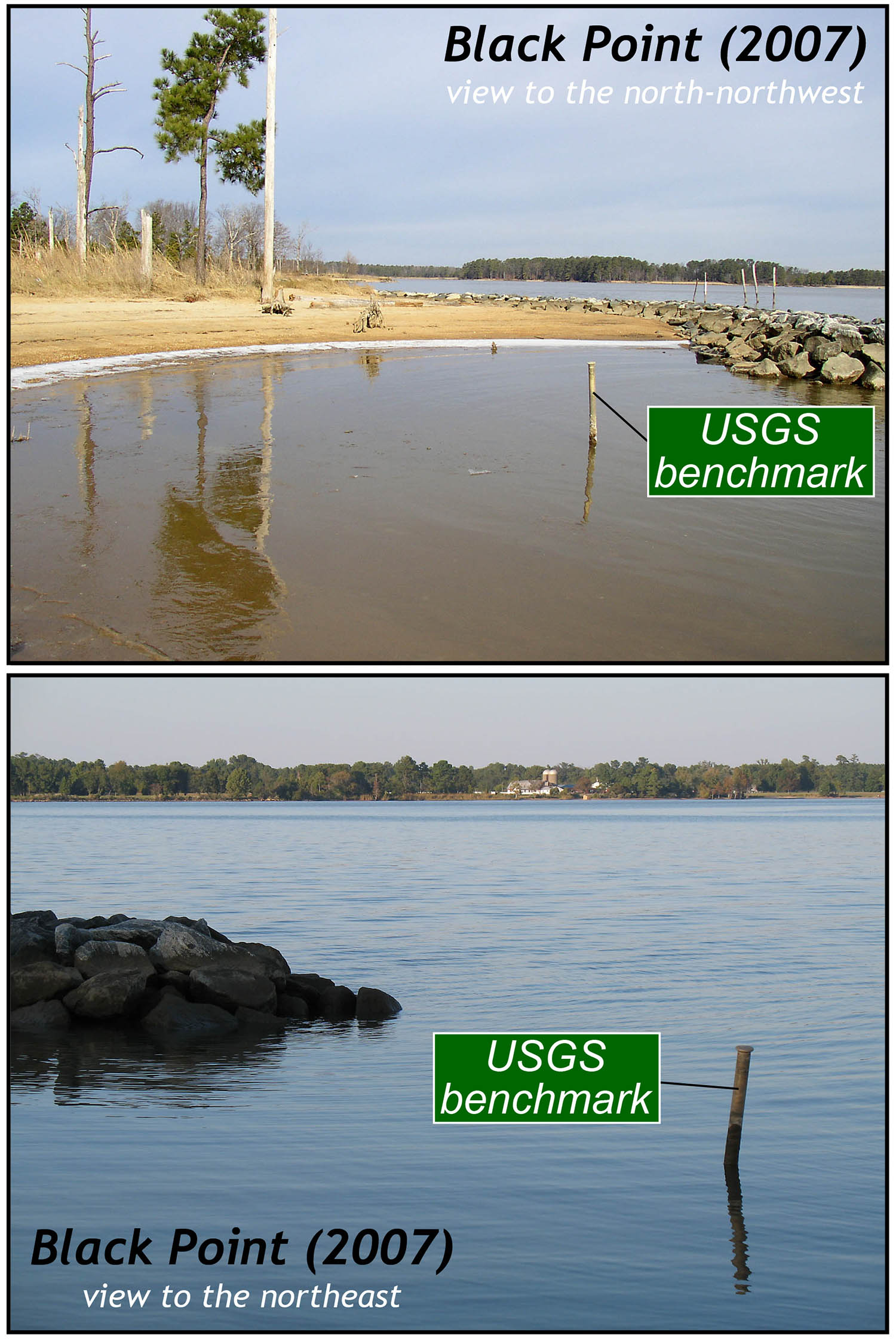
Black Point requiem. The USGS benchmark was on land in the 1980s, by the early 2000s the marker was well out in the waters of the James River. In the upper image note the dead pine trees.
Black Point is a sentinel recording the impact of rising sea-level in eastern Virginia. Over the past 35 years, the shoreline has retreated by more than 100 feet (30 m) at some locations. In the early 2000s, a huge effort and a pile of money was spent on hard revetment – breakwaters to ‘shore’ up and slow the coastal erosion along much of Jamestown Island’s southern and eastern edges.
The breakwaters and hardened shorelines are created by piling large (up to 3-4’ in diameter) blocks of quarried bedrock (barged in from the Richmond area) along the shoreline or just offshore with the idea that the large stones break up incoming wave energy, and in the process, slow coastal erosion. This effort has not met with great success. In just the small area around Black Point more than an acre of land has been submerged in less than a generation. But it’s not only the loss of land – there’s dramatic ecosystem change as the rise of brackish water is killing the forests, and much of Jamestown’s eastern shoreline is rimmed with ghost forests of dead and dying pines.
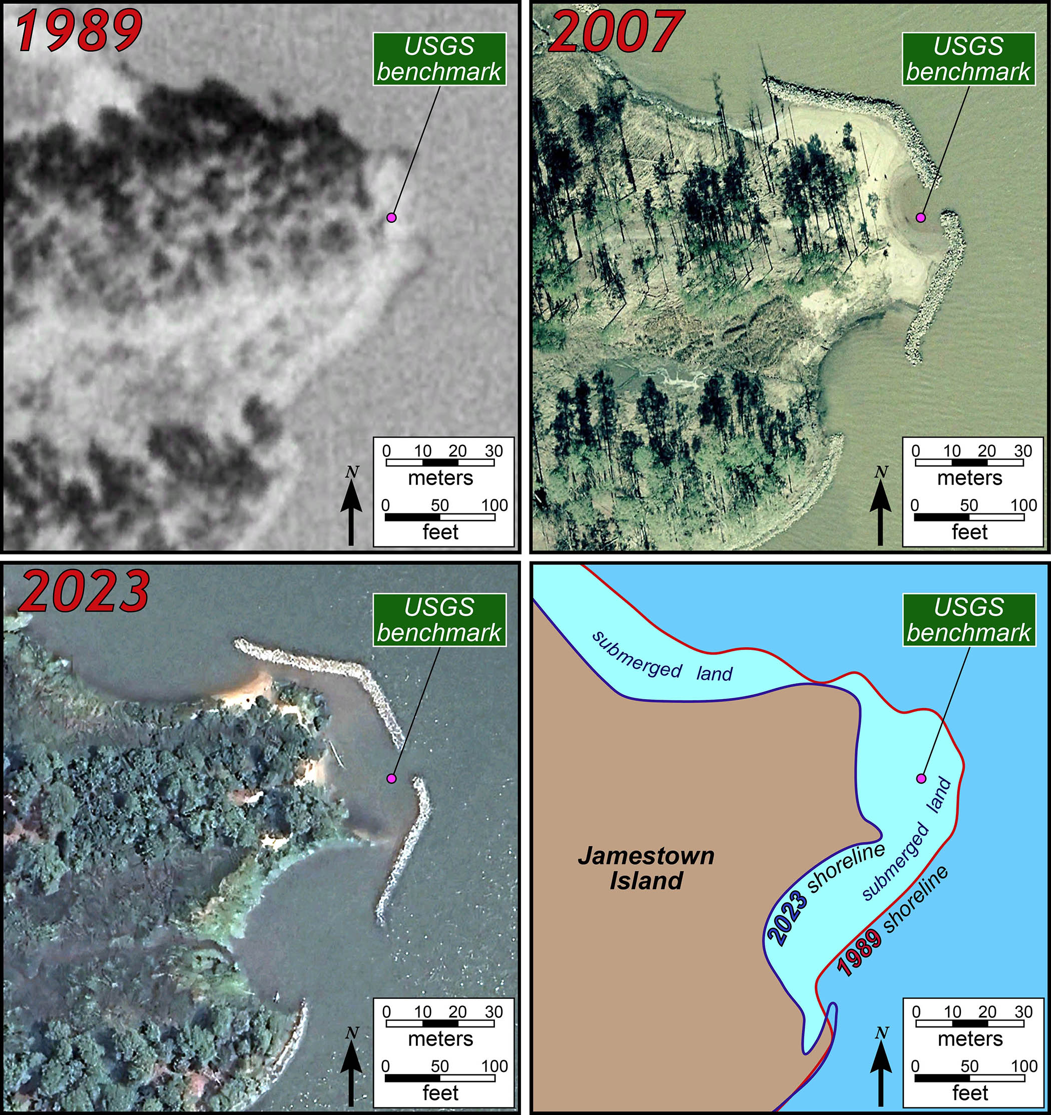
Aerial imagery of Black Point from 1989, 2007, and 2023. Note the location of the USGS benchmark. The map on the lower right summarizes the shoreline erosion during this time interval.
Across Tidewater Virginia sea-level is rising at an alarming rate. The graph below illustrates the mean monthly sea-level at Sewells Point (at the mouth of the James River). As expected, there’s a bunch of month-to-month variability, due to specific weather events, but the overall trend is clear. Since 1990, sea-level has risen nearly 9 inches (22 cm) at Sewells Point, by simply fitting a straight-line to these data, we obtain at yearly rate for sea-level rise of 0.24”/year (6.5 mm/year). But the straight-line fit is an underestimate, numerous studies document that sea-level rise is not steady but rather accelerating.
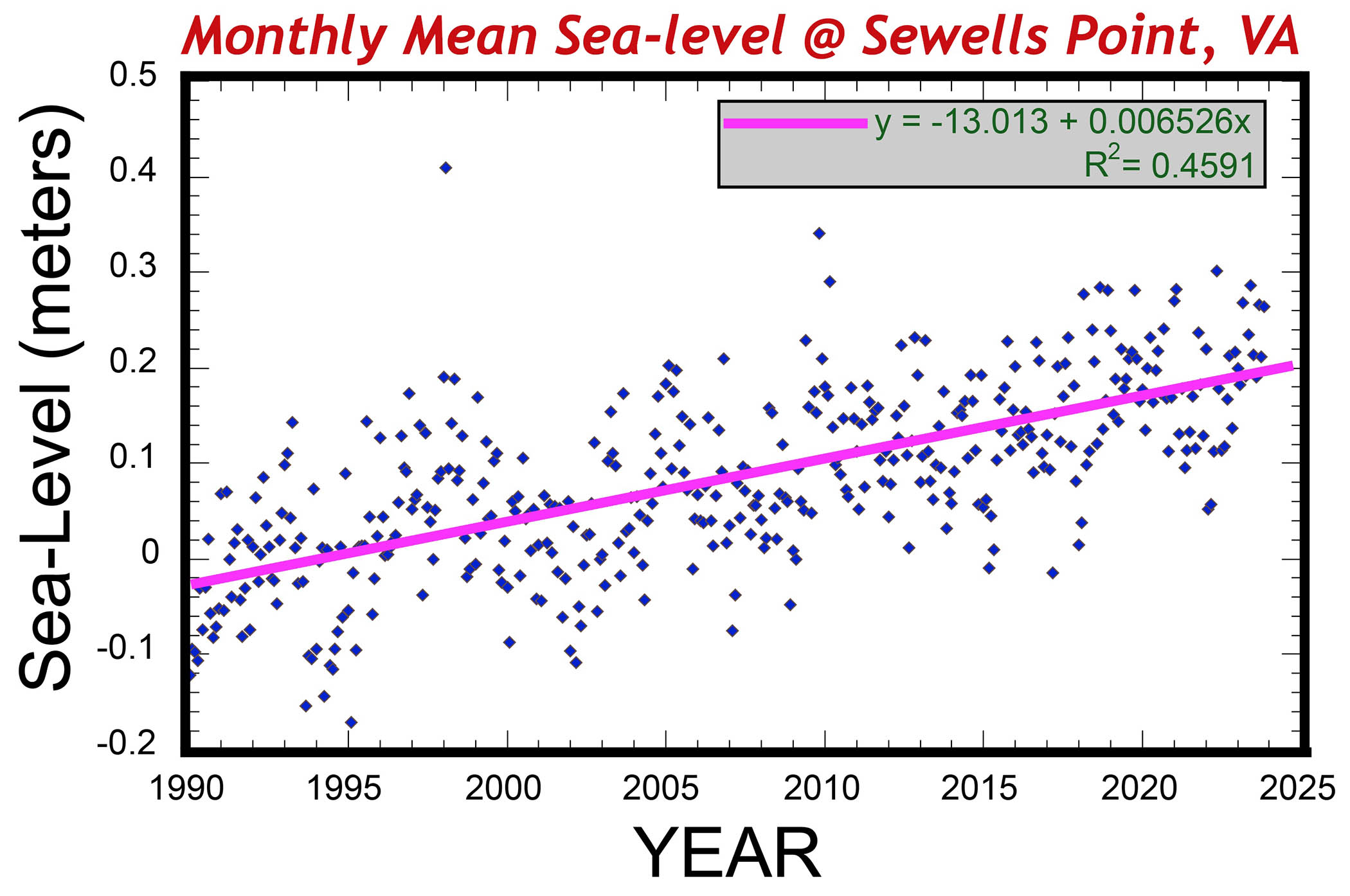
Graph of mean monthly sea-level at Sewells Point, VA from 1990 – 2024. The pink line illustrates the linear best fit of these data, which is ~1/4″ per year.
What happens to Jamestown Island with one foot (30 cm) of sea-level rise?
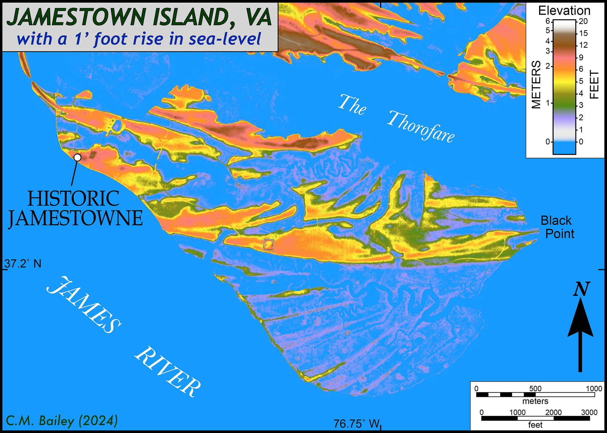
Jamestown Island with 1 foot of sea-level rise. Notice how much of the island is now submerged.
With sea-level a foot higher, the southern half of the island will be almost completely submerged while the low ridges, with just a foot or two of relief above the waterline, will be clad in ghost forests of dead trees.
The main historic complex sits on relatively high ground and looks intact, but it’s complicated. Historic Jamestowne is protected from the James River by a century-old sea wall that’s in need of a major refit. But it’s the rising waters from the Pitch & Tar Swamp, that will cut off the historic area from the infrastructure to the north. The historic James Fort site will likely become its own islet as Jamestown Island drowns. The incursion of brackish water is already destroying archaeological sites and it’s only going to get worse. David Givens, Jamestown Rediscovery’s Director of Archaeology, describes their job as one of, at best, archaeological triage.
How long will it take for a foot of sea-level rise? If we extrapolate a rise rate of ¼“/year, then it’ll take 48 years, but recall that the rate of sea-level rise is accelerating and it’s quite possible this watery scenario is less than two decades in front of us.
W&M Geology and Research at Jamestown
William & Mary geologists have conducted collaborative research at Jamestown for more than 50 years, but there’s more work to do as our interdisciplinary work sits at the intersection of uncovering the past and predicting future change in this historic setting. We’re excited about the geodiscoveries to come and realistic about the onslaught of environmental change ahead.
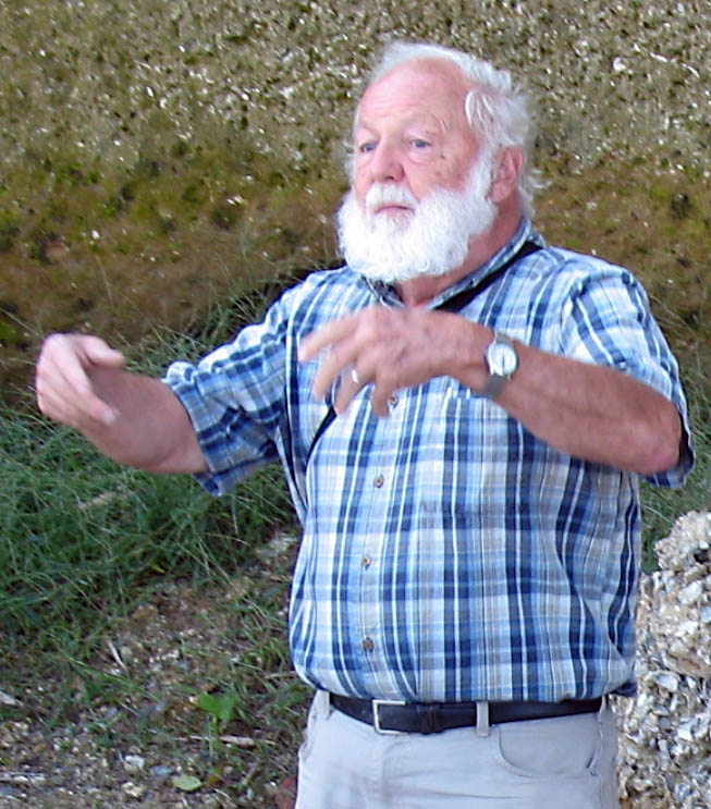
2007 photo of the late W&M Geology Professor Gerald Johnson
The late W&M Geology Professor Gerald Johnson first conducted geological research at Jamestown Island in the 1960s and continued that work (with numerous W&M undergraduates as well as high school students ) for decades. That research was wide ranging – they obtained sediment cores from across the island, analyzed pollen preserved in the sediment to reconstruct the island’s vegetation history, and also collected chemical data on the shallow groundwater. Many of those findings were published in Johnson and others (2000) as well as in a 2007 Virginia Geological Field Conference Guidebook. William & Mary Research Associate (and former State Geologist) Rick Berquist drilled deeper sediment cores from Jamestown and mapped the overall geology of the island in detail.
In the early 2000’s Emeritus Professor Steve Clement collaborated with Jamestown Rediscovery archaeologists to study the lithic materials discovered during excavations at the 1607 Fort James and surrounding areas. Much of the lithic material, commonly used for building foundations, are cobbles to even boulders of a distinctive well-cemented quartz sandstone that commonly preserves Skolithos, a tube-like trace fossil from a mysterious critter that burrowed in ancient sand some 530 million years ago. These rocks are native to the western Blue Ridge Mountains, but they are durable rocks, and as such withstood being transported hundreds of miles down the James River system to be deposited in Coastal Plain sediments over the past two million years. Rocks are rare on the Virginia Coastal Plain, so these transported rocks which erode out of local river bluffs, were put to use by the Jamestown colonists.
Yet, some of the lithic materials at Jamestown are more exotic, following up on Clement’s original work, my research student Kelsey Watson ’15 (W&M Geology) focused on characterizing a suite of volcanic rocks and a distinctive limestone amongst the lithic materials. These were ballast stones, used to provide weight and balance in the hold of the early 17th century sailing ships that arrived at Jamestown. Based on the petrography and chemistry of the porphyritic andesites, Kelsey demonstrated that these rocks were likely sourced from the western side of Dominica, one of the youngest and most active volcanic islands in the Lesser Antilles. The limestones are cross-bedded calc-arenites from Bermuda, brought to Jamestown by the survivors of the Sea Venture shipwreck who were stranded for 10 months in Bermuda from 1610-11.
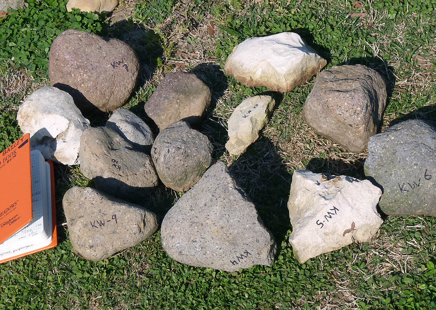
Kelsey Watson ’15’s (W&M Geology) research samples from Jamestown. These exotic rocks from Dominica and Bermuda were brought to Jamestown as ship ballast.
During the past 15 years, my colleagues Greg Hancock and Jim Kaste have worked with dozens of W&M undergraduate students studying the groundwater flow and chemistry at Jamestown Island – underneath and adjacent to the old fort. This work, supported by the National Geographic Society, showed that the groundwater beneath the fort is highly saline and receives flow from the Pitch & Tar Swamp during most of the year. Collectively, their work bolsters the hypothesis that a lack of fresh, clean water in both the river and groundwater wells contributed to the mortality and overall struggles of the early colony (i.e., the Starving Time of 1609-10).
For nearly a decade, Linda Morse and a legion of William & Mary student volunteers ran the EdShed program at Jamestown, an educational effort to bring natural science to the public in this historic space.
The William & Mary Geology Department takes a broad view on geology – from our perspective, it’s not only the earth, but also wind & fire plus so much more. At William & Mary, we’re the scientists studying water and weather, connecting climate to change, and linking all that across time – from Deep Time to the Anthropocene.
We’re stoked to be growing our long-term partnership with Jamestown Discovery, this semester my Geological Field Methods course is making the island a focal point of their studies. My faculty colleagues Dom Ciruzzi and Joanmarie Del Vecchio, with expertise in ecohydrology, low-elevation remote sensing (just say, drones), geomorphology, and dendrochronology, have fresh ideas and new angles for research on Jamestown Island. Our paleobiologist, Rowan Lockwood, is keen to examine the horde of early 17th century oysters discovered on site. Jim Kaste and I just commenced a project using new techniques to characterize and source the origin of more weird rocks discovered in a newly excavated well. Geodiscovery at Jamestown!
Jamestown and the record of its human history is in a precarious spot – we must learn what we can and adapt for the future. I’ll finish this long post with a snippet from Professor Gerald Johnson’s 2000 work:
“The past, present and future of Jamestown are tied inextricably to sea level change – Jamestown Island was created by water and it will ultimately be destroyed by it.”


No comments.