
Gladiator Games over the James
The Gladstone Gladiators have spent the past two months dividing their time between geological field research in central Virginia and lab research in the Geology department at William & Mary. They’ve made great progress, mapping through the summer heat and, in the process, are working out the complex structural architecture of the Piedmont. Our research is funded by a U.S. Geological Survey grant, and their geological map is taking shape.
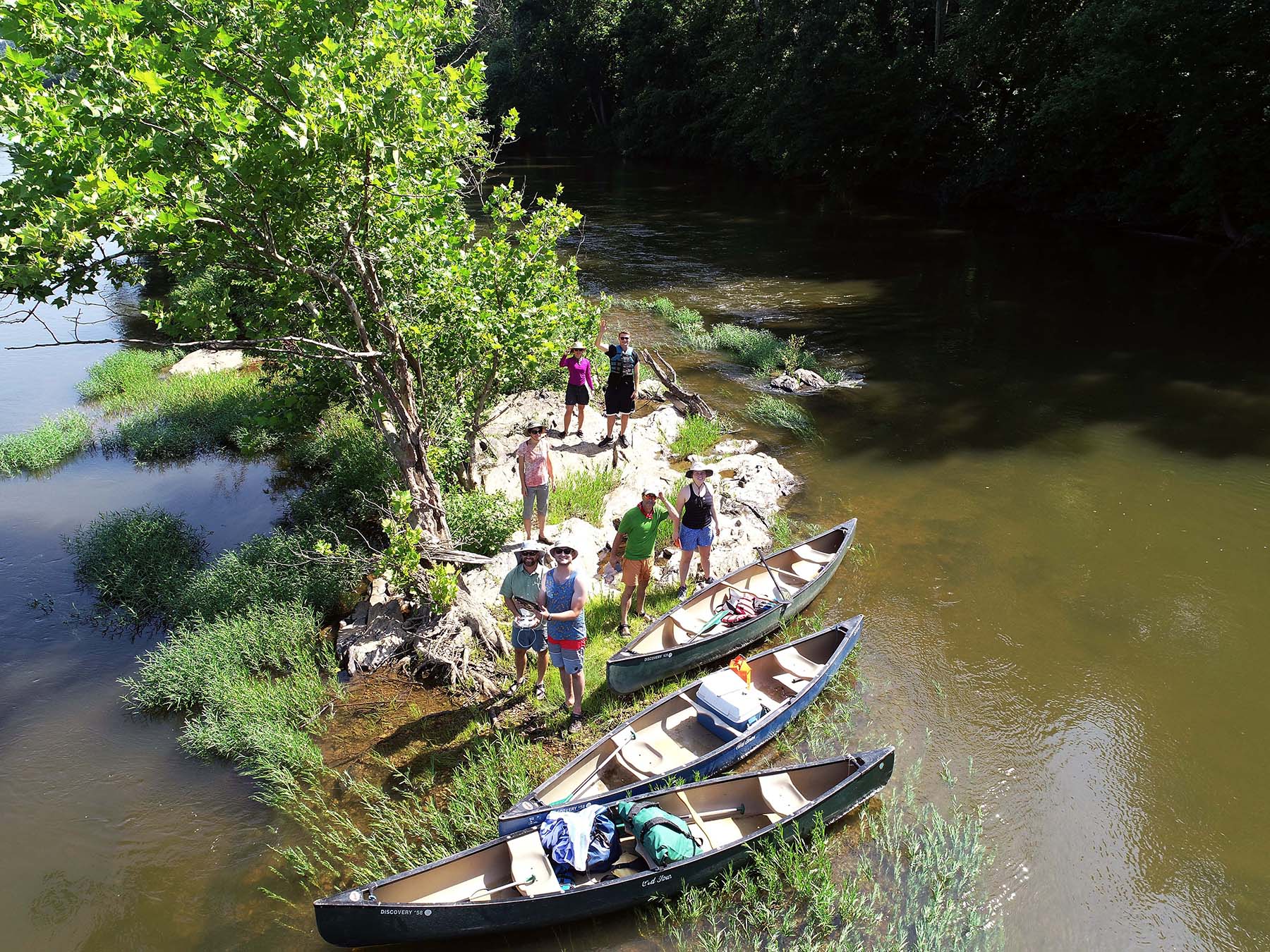
Last week, the Gladiators left terra firma to float down the James River and examine bedrock exposed in the river bed. Field work by canoe is a perfectly sane way to conduct research in sultry weather! However, the Gladstone Gladiators weren’t just amphibious — they added a bold and new aerial component to their research. With the guidance of Pete Berquist ’00, a professor at Thomas Nelson Community College, we flew a drone over the James to acquire low-elevation aerial imagery to help with our mapping and structural analysis.
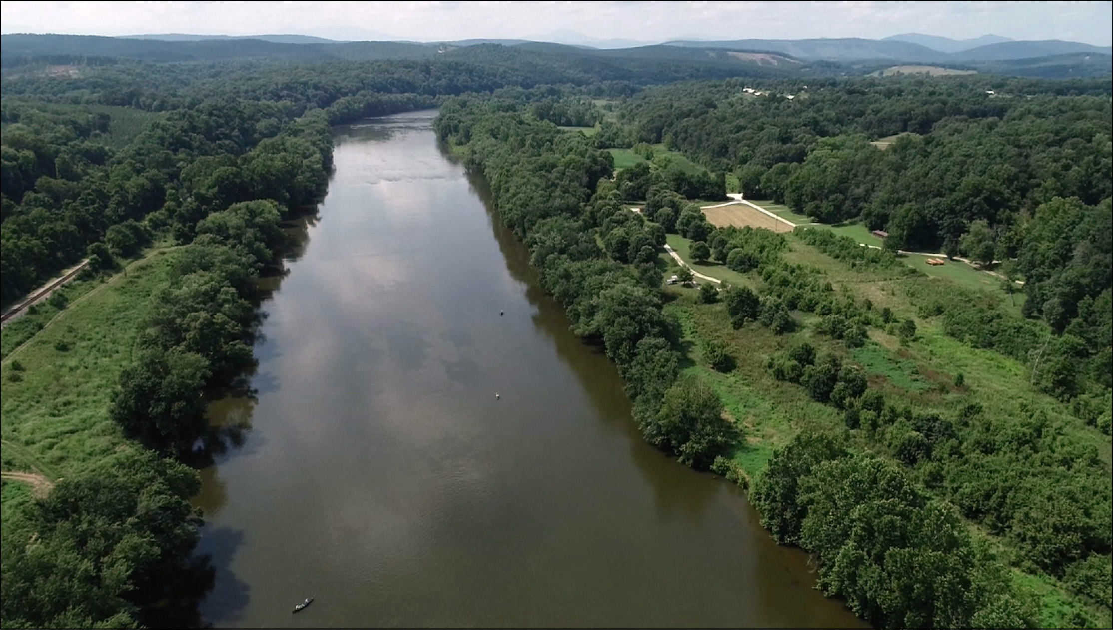
The James River from an oblique aerial view (to the northwest) near James River State Park in Buckingham County, Virginia. Can you find the three canoes paddled by the Gladstone Gladiators?
Sam Belding’s senior research is focused on describing and quantifying fractures and faults that cut the bedrock in our study area. He wants to understand the physical conditions and causative stresses that cracked these rocks. Although it’s an academic project, the results have applied value as well. Sam’s data indicates that hard and durable rocks, such as diabase and quartzite, are thoroughly fractured (high fracture density), whereas anisotropic and elastic rocks, such as phyllite and schist, are typically less fractured (low fracture density). Rocks with high fracture density typically make good aquifers as the abundant cracks provide ample space for groundwater. Our geologic map and the associated fracture studies can be utilized to better locate groundwater resources.
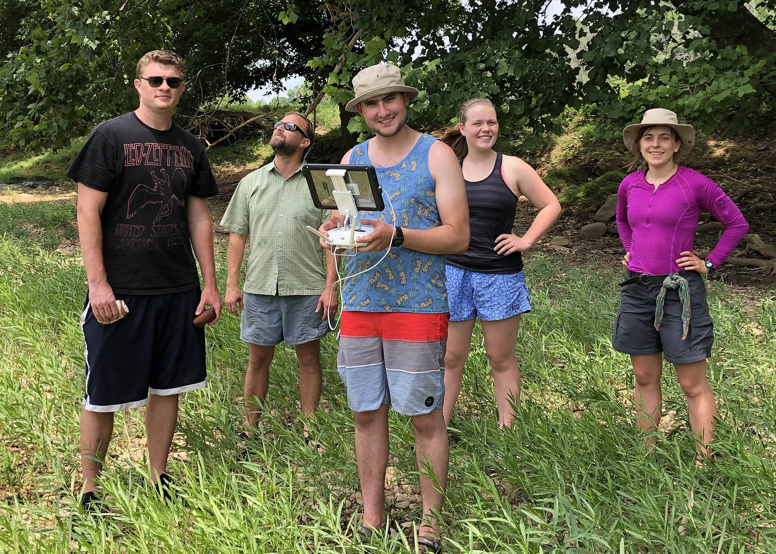
Sam Belding (center) remotely piloting a drone to collect data for his geology senior thesis. He’s joined from left to right (or is that west to east?) by Ryan Walter, Pete Berquist (W&M Geology alum and professor at Thomas Nelson Community College), Emily Hinshaw, and Evan Laughlin.
In central Virginia, the James River ranges from 100 to 150 meters wide (330 – 500’), and, under low-flow conditions, its depth is typically much less than 50 cm (1.5’). For such a wide channel, it’s rather shallow so the bottom of the James River is easily discerned in Google Earth satellite imagery. This summer, we’re attempting to use drones to collect higher-resolution imagery of the James River channel. Sam is comparing both the satellite data and the low-elevation aerial imagery to fracture geometries obtained from traditional geological measurements at specific outcrops.
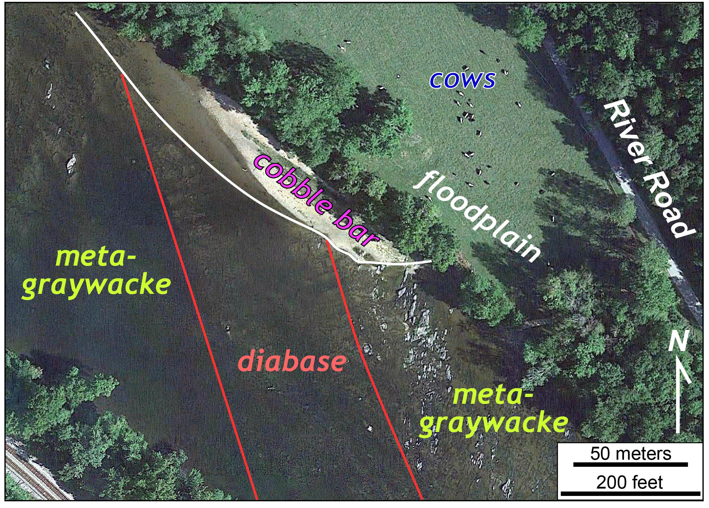
Annotated Google Earth image of the James River (at low-water) near Gladstone, Virginia. Note the bedrock outcrops exposed in the channel and fractures that are evident in the bedrock, even below the waterline. The diabase forms a dike, ~70 meters wide, that intruded into older metamorphosed rocks (meta-graywacke). At the river’s edge, bedrock is covered by sediment on the cobble bar, as well as beneath the alluvial deposits of the floodplain.
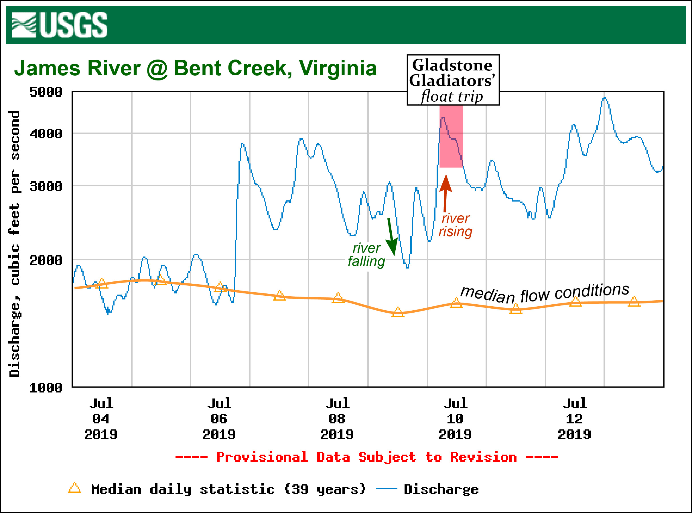
James River discharge at Bent Creek, Virginia from July 4 – 13, 2019.
The only hiccup came from the river itself. On the day prior to our float trip, the river was flowing at near normal conditions and dropping to lower flow levels. This was encouraging.
But during the 12 hours prior to our trip, the river-level rose (primarily due to water releases from dams upstream of Lynchburg). At Bent Creek, the U.S. Geological Survey’s stream gauge reported that the river discharge doubled, and the water level rose about 20 cm (8”) from one day to the next. Overall, this was a modest rise in the river’s level, but that was 20 more centimeters of water to cover the rocks that we’d hoped to image and study. To further complicate things, as the river level rises, the water typically grows more turbid and clouded with sediment, and thus it becomes harder to see through the water column.
Nevertheless, it was a brilliant summer day. So down the river we went with our eye-in-the-sky.
First flight!
For the earth scientist, there is much to see from a vantage point that’s 10 to 100 meters above the surface of a dynamic environment such as the James River in the Piedmont. This is a realm of water, sediment, rock, and vegetation that changes over time. Our photos illustrate a wealth of details about the river and the rock it flows over.
Here are the details from one outcrop. This image looks more-or-less straight down at the river, and a set of bedrock outcrops above the water. The canoes provide a sense of scale (but for those who prefer, a scale bar is included on the annotated image). A close inspection of the image reveals Sam and Pete working the drone.
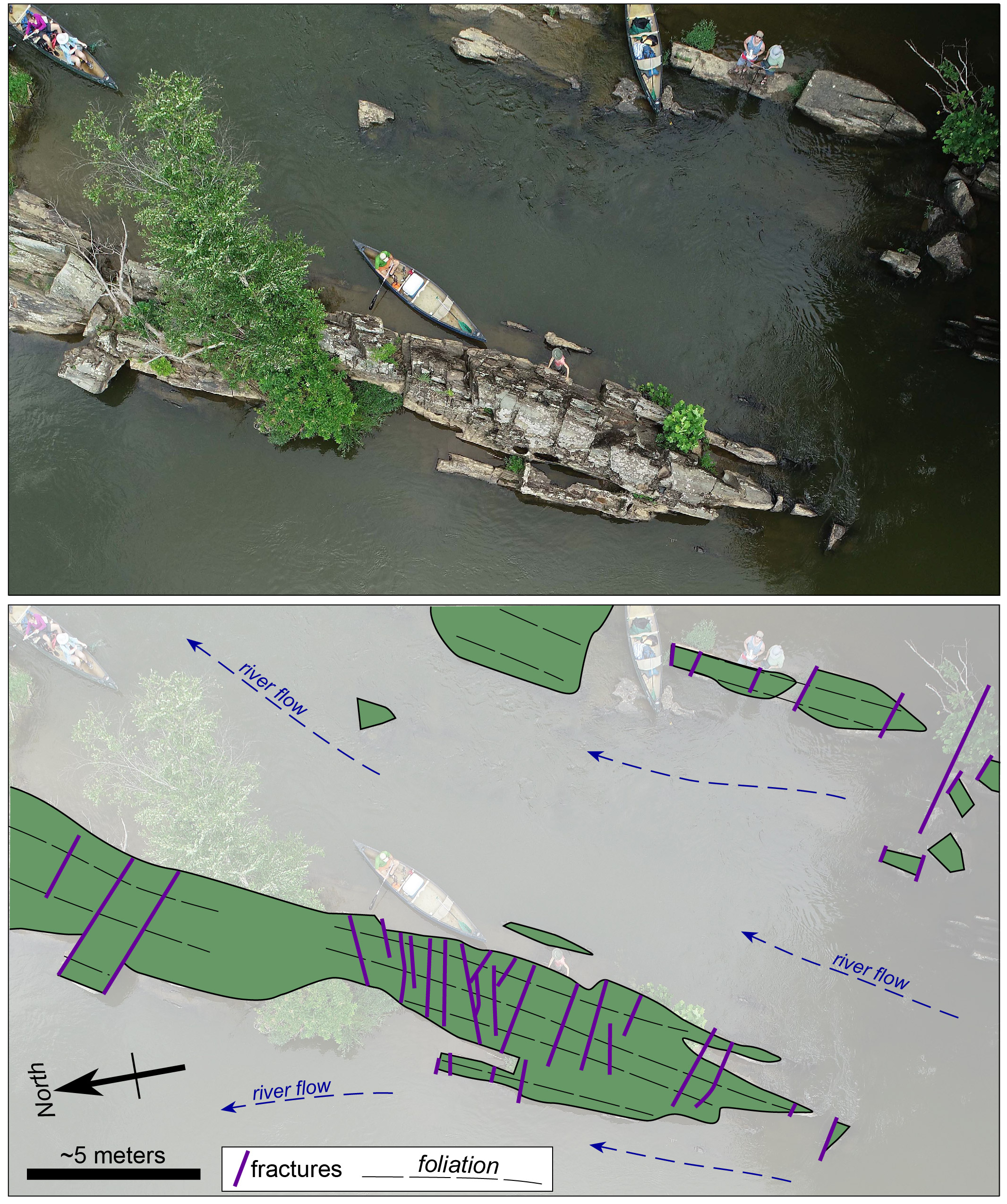
Aerial view of an outcrop in the James River
The outcrop exposes a foliated greenstone. Greenstone is a metamorphic rock originally formed as basalt and was likely once a lava flow erupted into an ancient ocean. At some time, well after the rock solidified, this basalt was buried deeply enough to cause the original igneous minerals to recrystallize into new metamorphic minerals. While at high temperature and pressure, the rock was squeezed and sheared such that the new minerals grew into a parallel arrangement that created a planar fabric (foliation) throughout the rock. Millions of years after metamorphism, as the greenstone was uplifted, stresses were sufficient to create the sets of nearly parallel fractures (illustrated in purple on the annotated image) that cut through the rock.
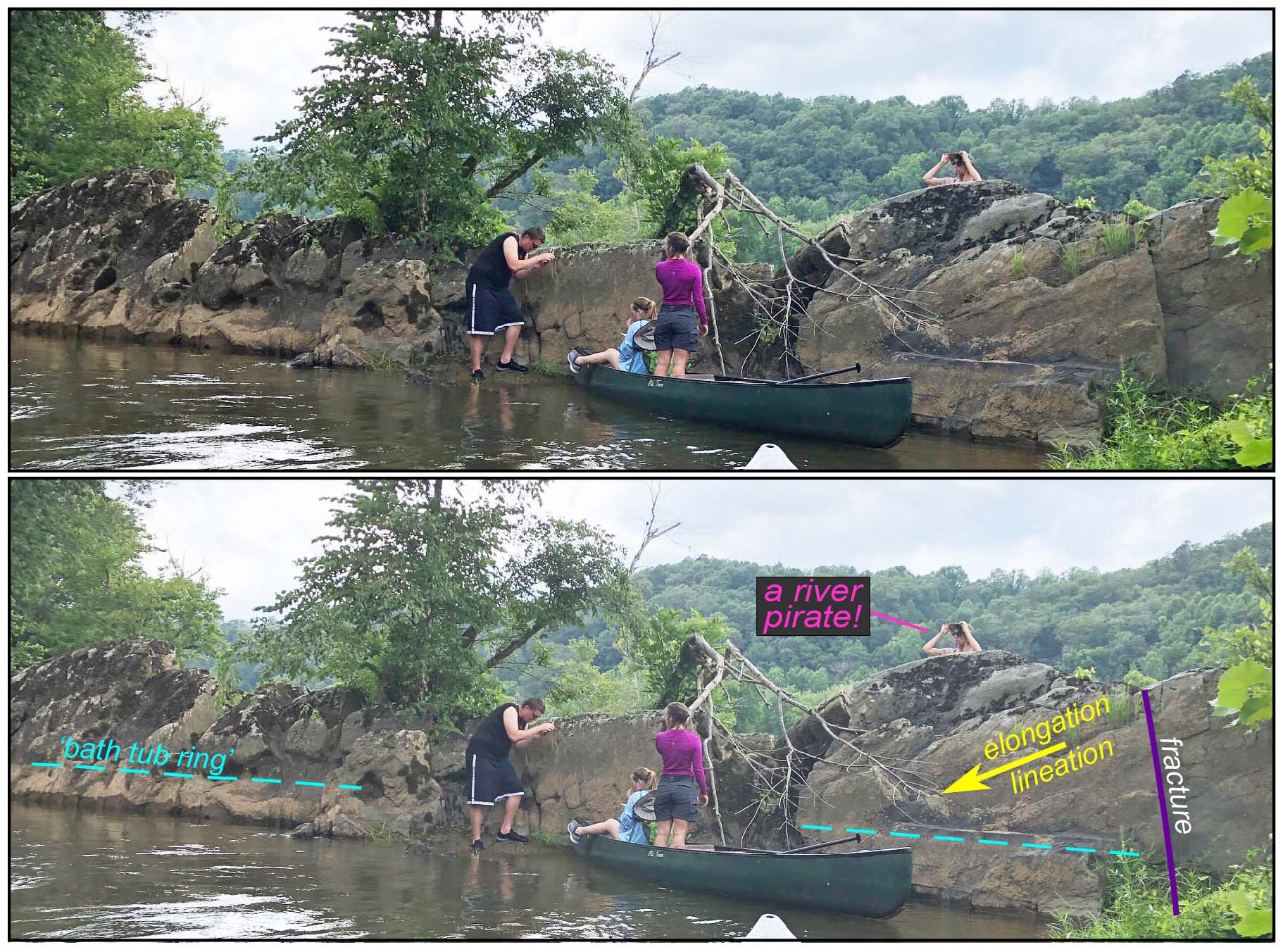
A view from the water. The outcrop forms a rock fin that extends from the water. The elongation lineation plunges to the southwest. Note sediment deposited along the outcrop during periods of higher flow which leaves the ‘bath tub ring’.
There are many modern processes at work in the James River’s channel. In map view, the main outcrop forms a canoe-shaped prow that tapers up-stream into the river’s flow. On the surface, the outcrop forms a pronounced fin, well above the normal river level. Greenstone is a hard rock, and, along this stretch of the James, most of the outcrops and riffles in the river have foundations of greenstone. Curiously, away from the river, greenstone rarely forms outcrops and is typically mantled by thick soil. Although, the greenstone is resistant to mechanical weathering, it is easily chemically weathered in central Virginia’s warm and moist climate.
The James River provided us nearly perfect conditions for an exceptional mid-July canoe trip. Although the discharge was a tad too high for seeing the river bottom in all its geological glory, the Gladiators are primed to try again — likely in early Fall when the river, after a long hot summer, has much less water in its channel. We want a trickle of water and acres of bedrock outcrop – it’ll make for a difficult and tedious float, but we’ll acquire better imagery.
In the summer of 1999, Pete Berquist was a William & Mary undergraduate and worked with me on my first EDMAP grant. He studied the ancient basement rocks in Virginia’s Blue Ridge Mountains. Twenty years on, I’m still working with William & Mary undergraduates on these field studies. Our recent research float trip was great because it brought different generations of W&M geologists together to learn and explore the earth — the circle is unbroken!
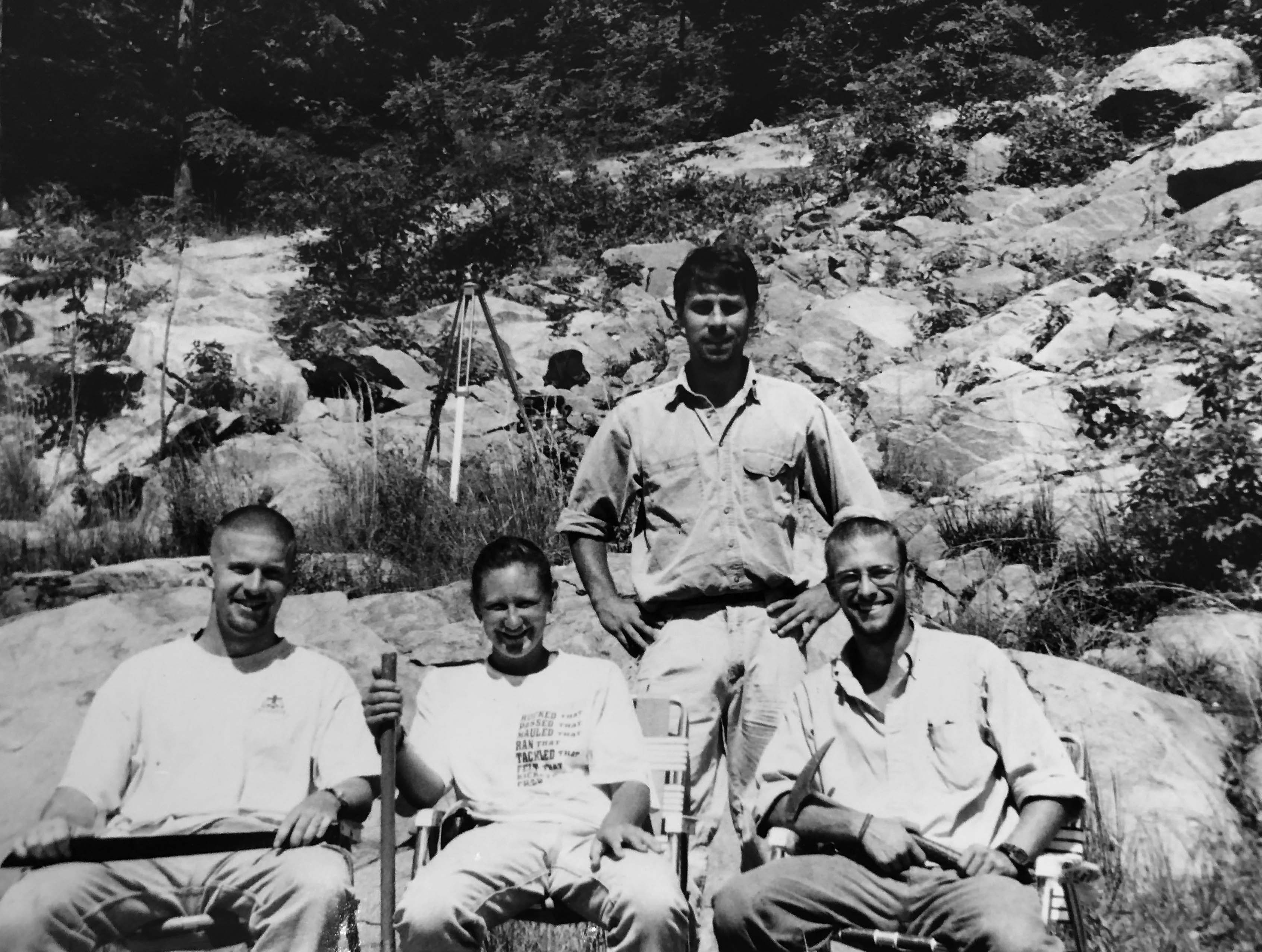
The Grenvillian Uberjocks in the Blue Ridge Mountains during the summer of 1999. W&M Geology students include (from left to right Nate Shotwell, Stephanie Mager, and Pete Berquist). Note the black and white photo – 1999 was a long time ago!
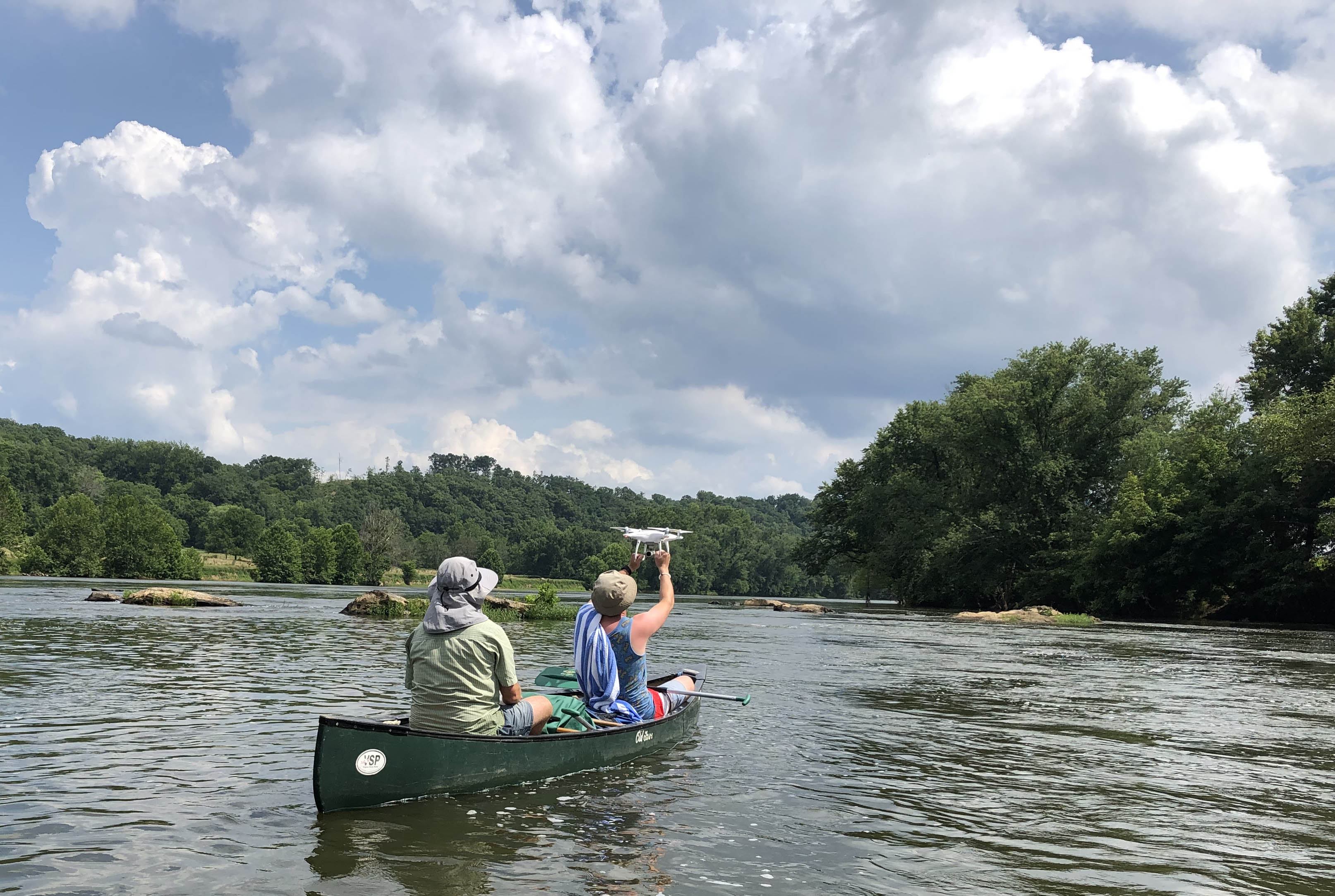
Pete Berquist ’00 and Sam Belding ’20 launching a drone from a canoe on the James River during the summer of 2019.
For more on the Gladstone Gladiators check out their Facebook page and Twitter account.

Comments are currently closed. Comments are closed on all posts older than one year, and for those in our archive.
Love the drone views! Especially the cows!
Glad to see drones being used for geologic research!