
Crabtree Falls and Landscape Disequilibrium in Virginia’s Blue Ridge Mountains
Back in October, early on a Saturday morning my Earth’s Surface Processes students loaded into vans and we headed west to the Blue Ridge Mountains for our weekend class field trip. All total, there were 52 of us on the field trip in six vans – we were rolling deep.
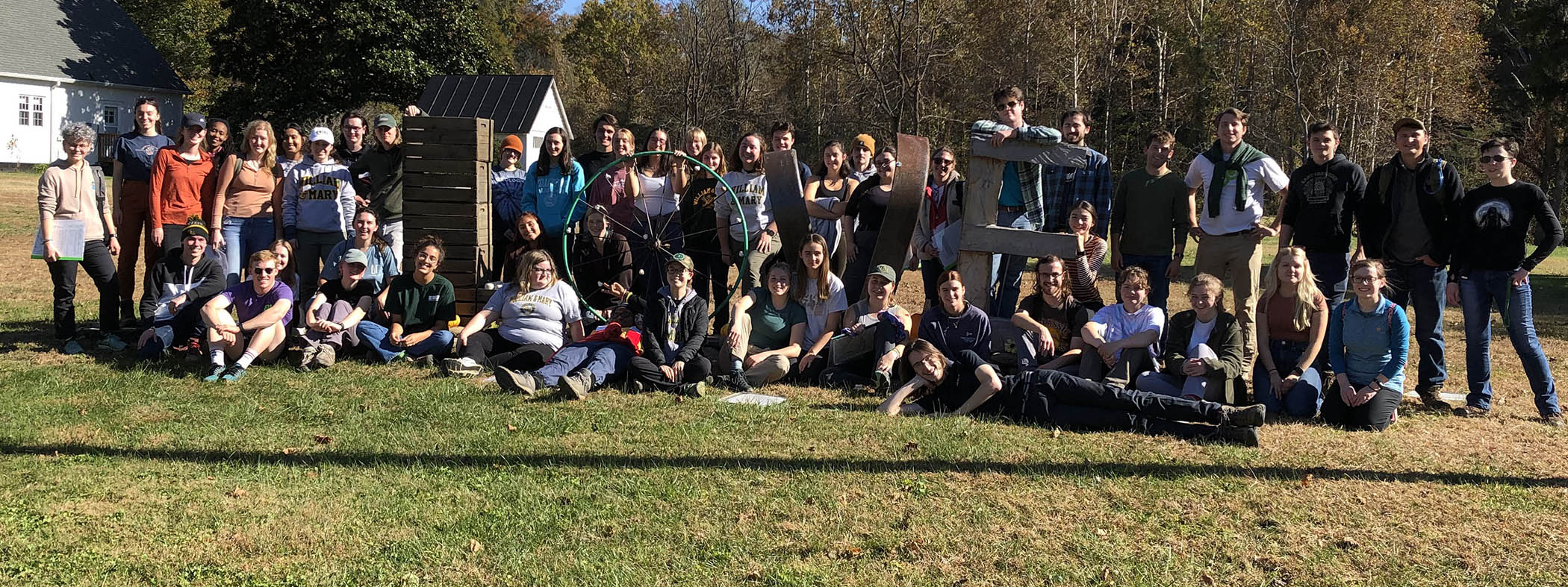
The 2022 William & Mary Earth Surface Processes showing some “LOVE” in Massies Mill at the end of their field trip to Crabtree Falls and the Blue Ridge Mountains.
Our first stop was at Crabtree Falls, a notable waterfall that’s commonly touted as the highest waterfall east of the Mississippi River. More precisely, it’s the highest cascading waterfall east of the Mississippi River. There are five major cascades and numerous smaller drops that collectively fall more than 300 meters (~1,000′) over a short distance. It’s a scenic corner of the Blue Ridge, and on beautiful Fall weekends it’s a popular tourist attraction with the attendant traffic jams in the parking lot.
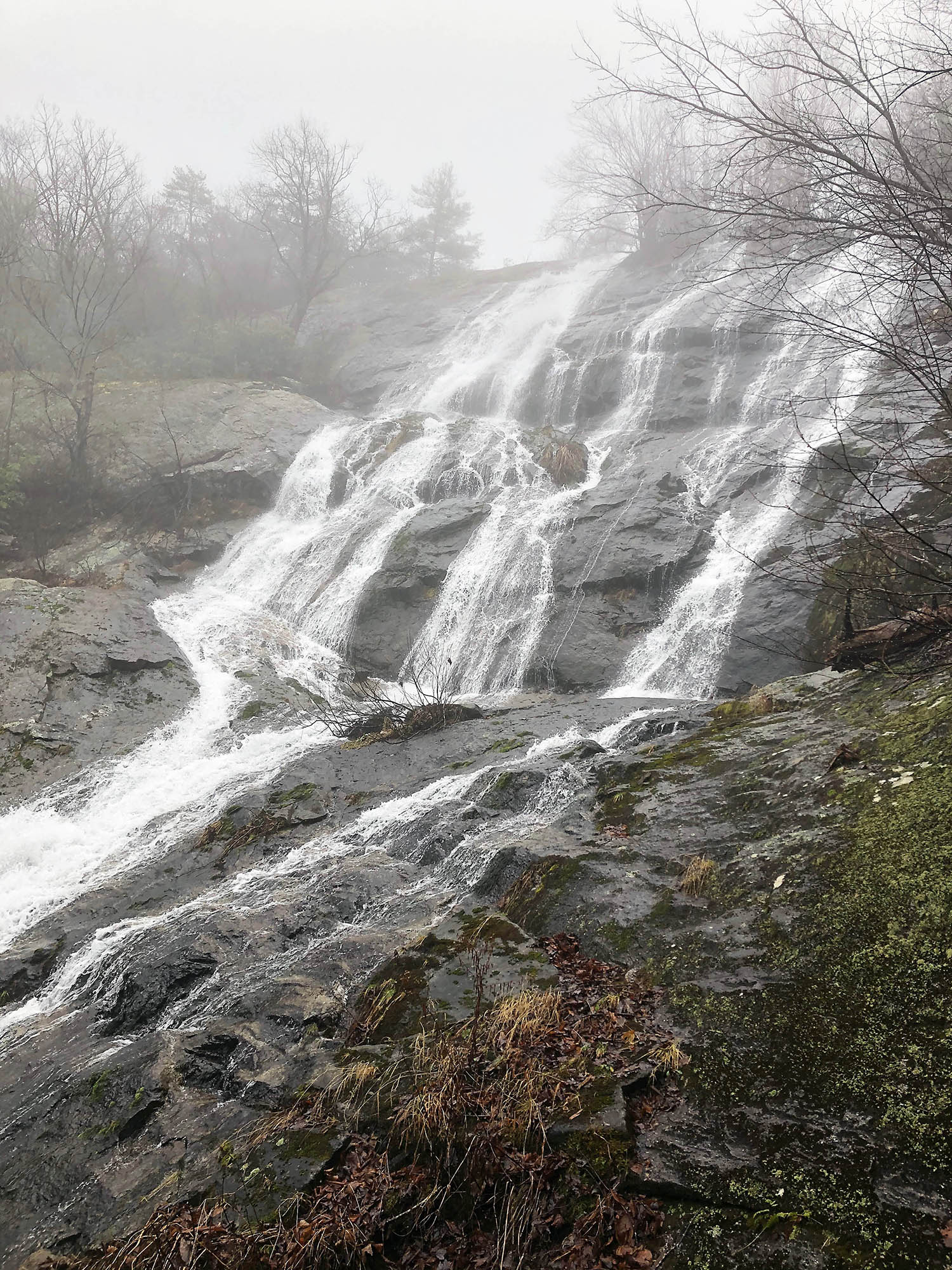
The upper cascade of Crabtree Falls, Nelson County, Virginia.
We arrived before the crowds and were off to other field stops by mid-morning. This post focuses on the significance of Crabtree Falls and how the local landscape reveals the hidden history of the Blue Ridge Mountains.
Let’s start with a few basics. Crabtree Creek is a small drainage that flows into the Tye River which drains the eastern side of the Blue Ridge Mountains in central Virginia. Crabtree Creek flows over a subdued upland that’s adorned with relatively few steep slopes for its first few kilometers. But in the last kilometer, before reaching the Tye River, this little creek dramatically plunges over one waterfall after another.
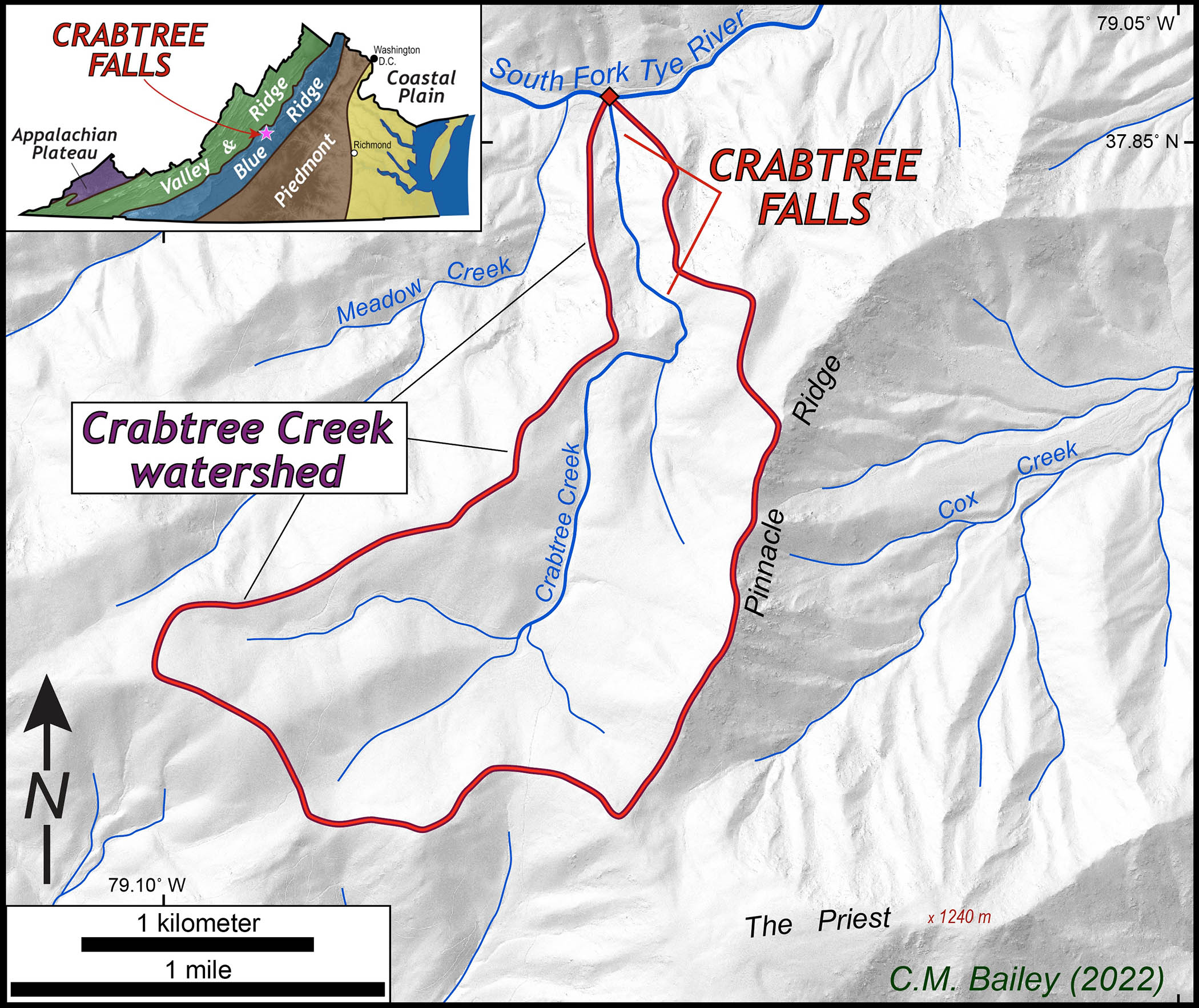
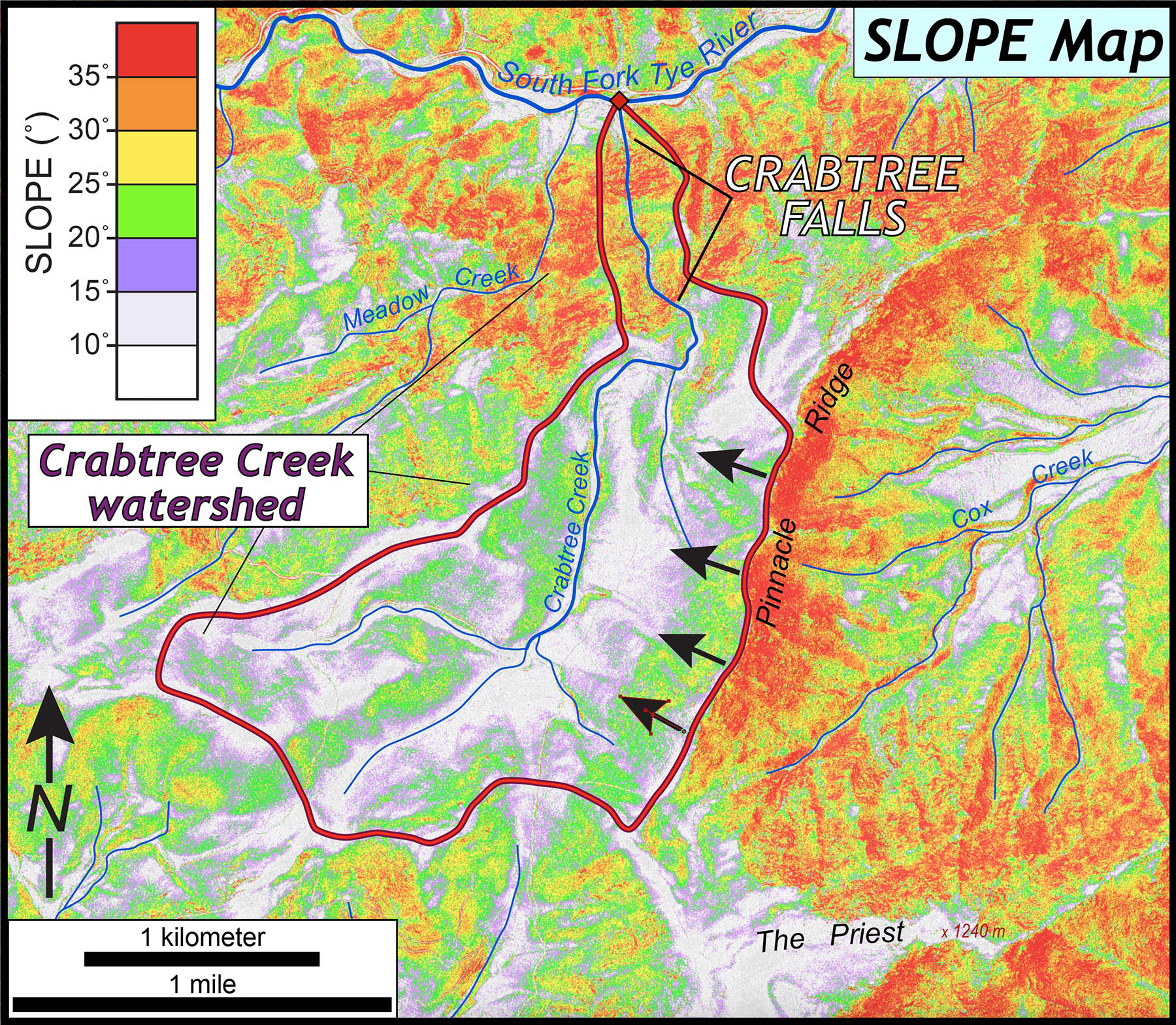
Shaded relief map of the Crabtree Creek watershed and Crabtree Falls, Virginia.
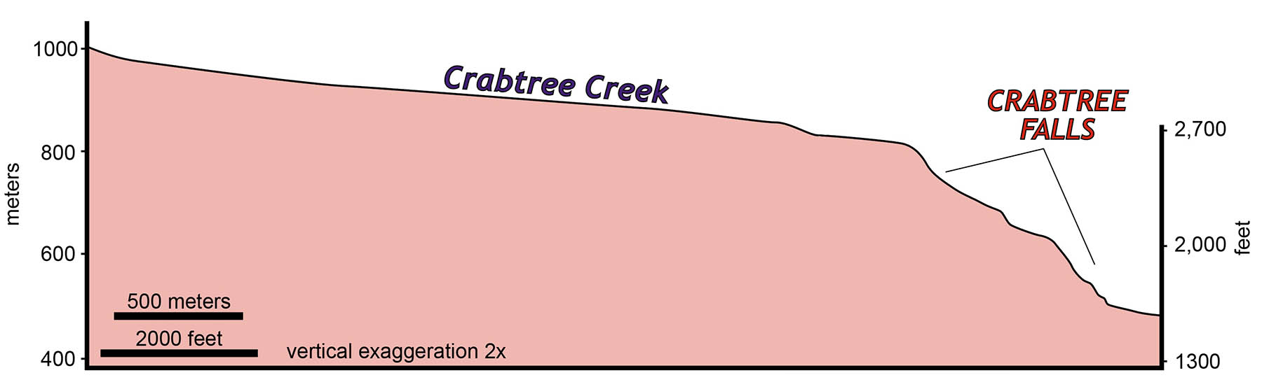
Stream profile for Crabtree Creek, note the modest slopes at higher elevations and steep drop at Crabtree Falls.
Crabtree Falls is a major knickzone, and as I’ve discussed before in this blog, knickpoints and knickzones are stretches of stream/rivers with significantly steeper gradients than either up or down stream. Geologists who study landscapes are keenly interested in the origin and temporal evolution of knickpoints. What’s especially curious about the Crabtree Falls knickzone is that it occurs near the bottom of the Crabtree Creek watershed.
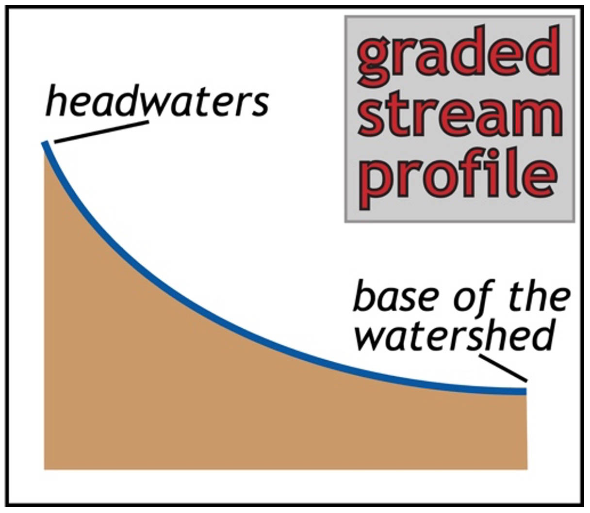
Idealized stream profile for a graded stream.
Many streams form a classic concave-up stream pattern that’s often referred to as a graded stream profile, the idea is that a graded stream adjusts its profile to carry the sediment load. In the headwaters with less discharge, the profile is steeper, but as discharge increases down the basin the slope decreases. Crabtree Creek is definitely not a graded stream.
Knickpoints develop for a variety of reasons. As streams cross harder, less easily erodible bedrock, knickpoints typically develop. Active faults that cut stream channels create knickpoints. Changes in the baselevel of a stream also spawn knickpoints that may, over time, migrate upstream throughout a drainage basin.
The Blue Ridge Mountains have the reputation for being an old mountain range, and there is no significant modern tectonic activity (earthquakes or active deformation) in the region to drive uplift. A common narrative is that the Blue Ridge Mountains formed a long time ago then slowly and relentlessly have been worn down to mere nubs of their former selves – this is not entirely true.

The bedrock near Crabtree Falls is an old granite (more specifically a pyroxene-bearing granite known as a charnockite).
In the central Virginia Blue Ridge, and more specifically in the Crabtree Falls area, the bedrock is a venerable old granite (actually a pyroxene-bearing granite known as a charnockite) that crystallized ~1,050 million years ago. Since the entire Crabtree Creek watershed is underlain by granite with a similar mineralogy and texture, it’s unlikely that the bedrock is responsible for the knickzone. What’s the origin of the Crabtree Falls knickzone?
Below is a slope map of the Crabtree Creek drainage and the surrounding terrain. This colorful map illustrates that the slopes are modest in the upper reaches of the watershed as well as near the summit of the Priest (it’s a distinctive name for a mountain). The steep slopes (>30˚) curiously occur in the lower reaches of Crabtree Creek as it dashes down to the South Fork of the Tye. It’s also clear that the east slope of Pinnacle Ridge and the north slope of the Priest are obscenely steep. Why might this be?
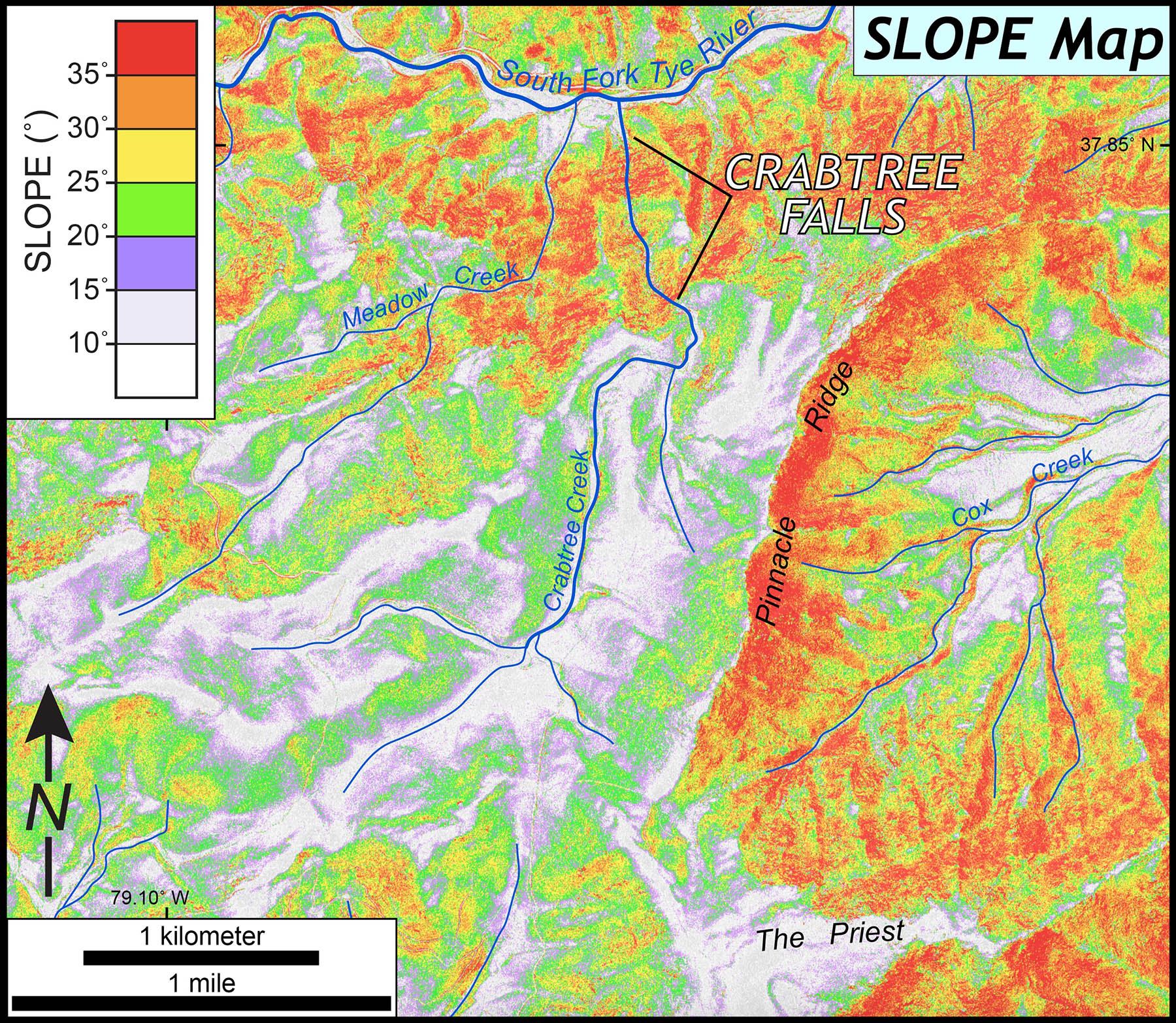
Slope map of the Crabtree Falls area, the warm colors are steep slopes. Headward erosion along the east side of Pinnacle Ridge will cut westward into the Crabtree Creek drainage basin over time.
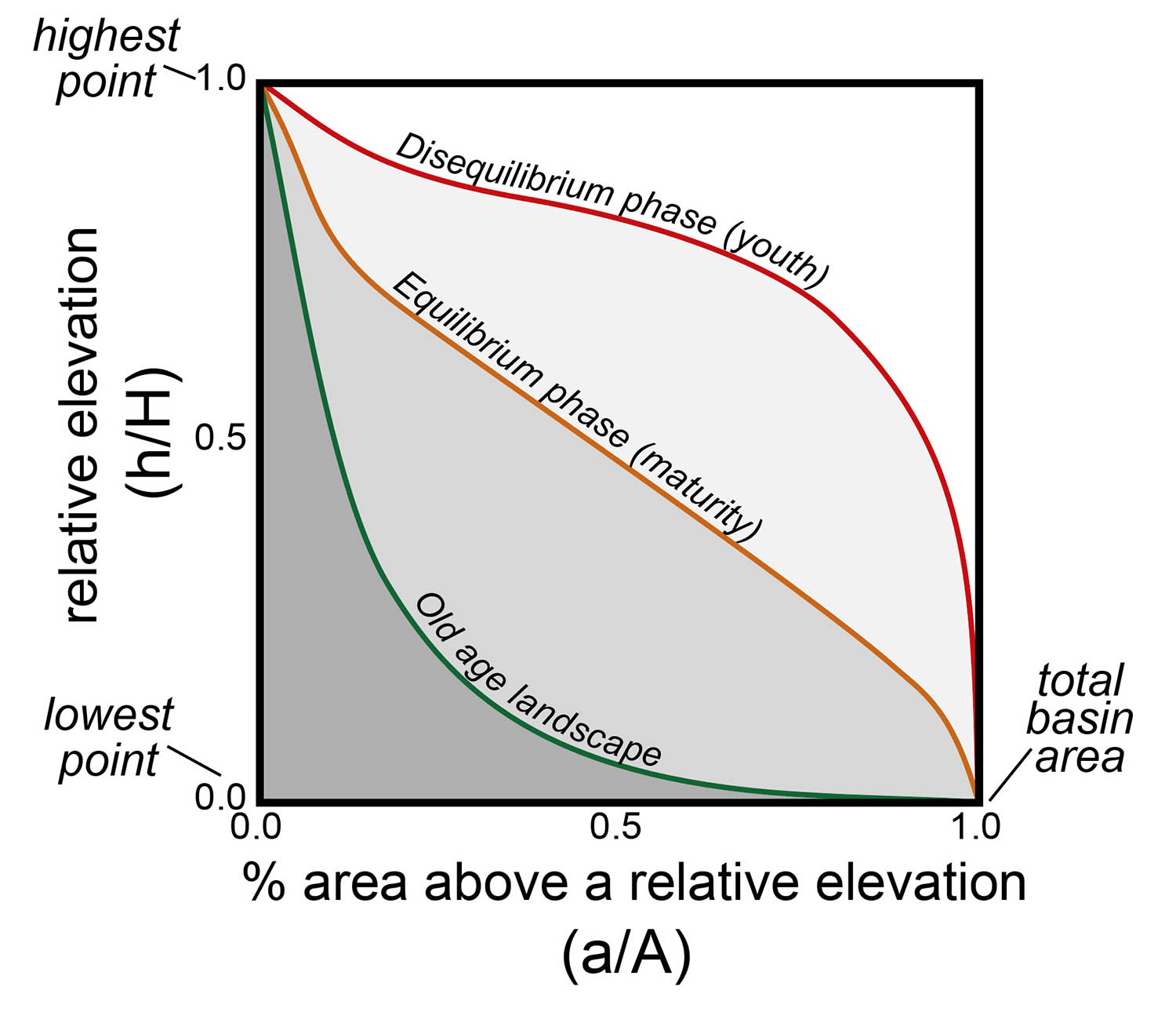
Idealized hypsometric curves for watersheds/landscapes of different age.
Another way to consider drainage basins is to conduct hypsometric analysis which involves quantifying the relationship between elevation and area in a given drainage basin. Landscape models predict that as a drainage basin ‘ages,’ the relationship between elevation and area will change in a systematic way — as more and more of the landscape is eroded from the upland reaches of a watershed the shape of its hypsometric curve changes.
Generations of geomorphologists have described landscapes as youthful, mature, or old. This model of landscape evolution does not necessarily imply age in a numeric sense, but nevertheless the model forms a reasonable framework for visualizing landscape change through time.
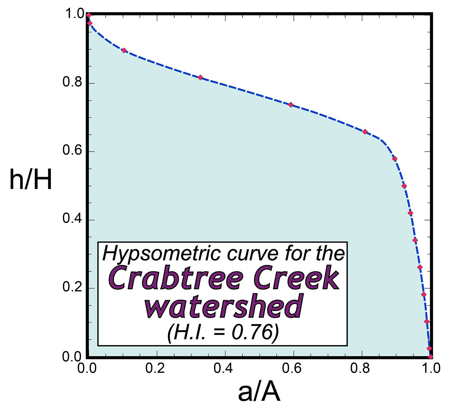
Hypsometric curve for the Crabtree Creek watershed. Note the high hypsometric integral (H.I) of 0.76.
Crabtree Creek’s hypsometry with its robustly high hypsometric integral of 0.76 is a classic example of a disequilibrium landscape that’s being rejuvenated. It looks as though the moderate slopes of the Blue Ridge uplands are part of an older landscape that’s being consumed by rapid incision and erosion. Over time the Crabtree Creek drainage basin is losing area as the drainage divide along the crest of Pinnacle Ridge migrates westward due to headward erosion in the Cox Creek watershed.
Slope map showing the movement of the Crabtree Creek drainage divide over time.
The Blue Ridge highlands in central Virginia are a composite landscape with older elements that are being destroyed by headward erosion and incision from modern streams such as the Tye River and its tributaries. In her 2015 thesis, William & Mary undergraduate Michelle Hoon-Starr identified a legion of migratory knickzones in the central Virginia Blue Ridge. These knickzones are the drivers of localized erosion, the generator of steep slopes, and create the region’s dramatic scenery.
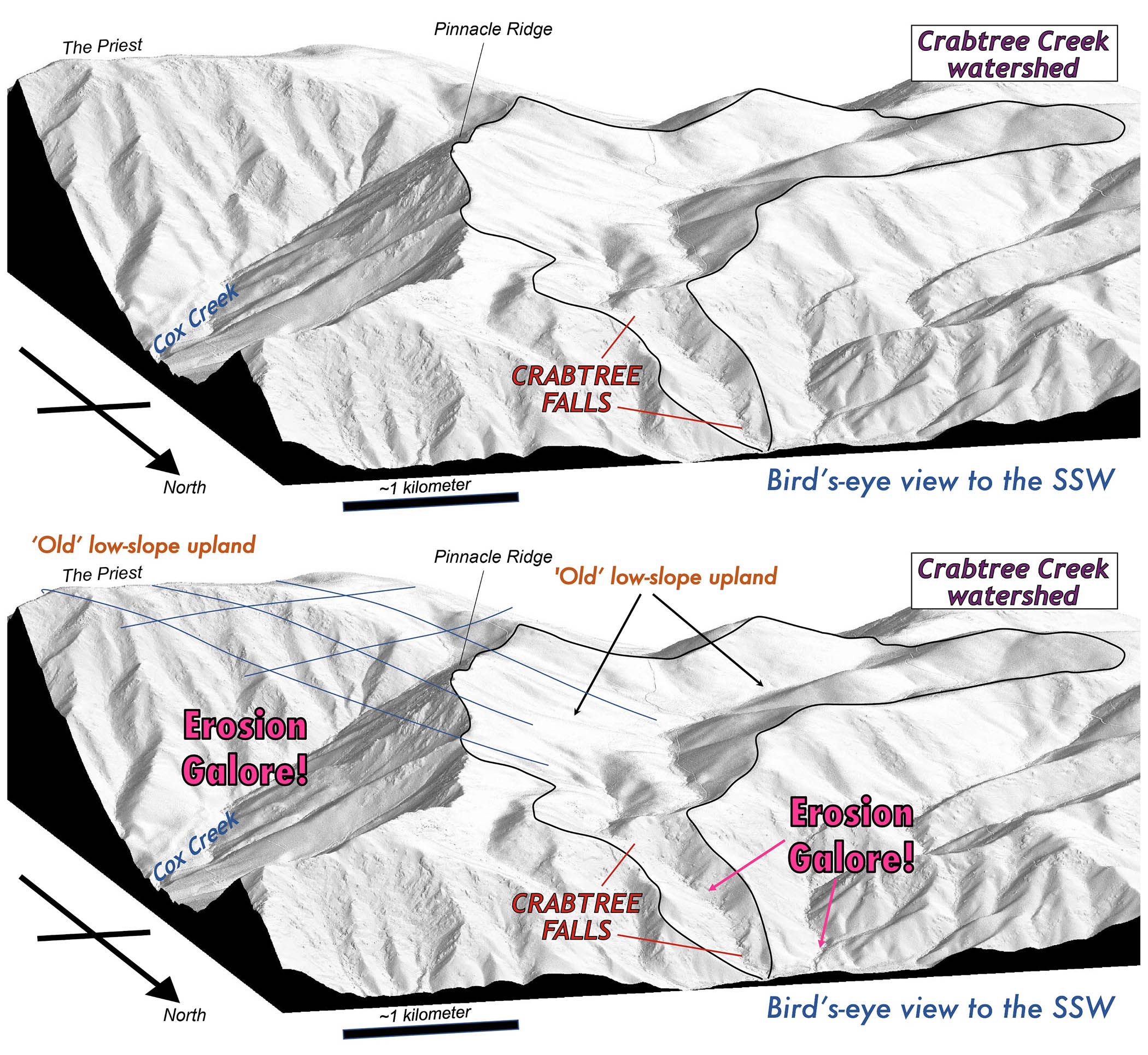
Oblique view (to the south-southwest) of the Crabtree Creek and surrounding area from a digital shaded relief map. In the lower image the ‘old’ low-slope uplands are labeled as well as areas where significant erosion is occurring. The Blue Ridge landscape near Crabtree Falls is a composite landscape with older and younger elements.
This, of course, leads to more questions about the Blue Ridge landscape. 🙂
- What’s the age of this ‘old’ landscape?
- What’s the cause of these migratory knickzones?
- Is regional topographic relief increasing or decreasing?
Taking the deep dive to answer these questions might require another whole blog post, so let’s stop here! But keep in mind that some of Virginia’s most exceptional scenery such as Crabtree Falls and the Blue Ridge are the result of recent (in a geological sense) landscape change.

Comments are currently closed. Comments are closed on all posts older than one year, and for those in our archive.
Nice blog post – even cooler oblique LiDAR DEMs. Did you ever get an answer to your questions?
Chuck,
This is Dan Glick. Give me a call. I would love to catch up
My number is (252)375-3077 . I hope to hear from you.
Thanks
Dan