
Bringing Back the Grenville! Preserving Virginia’s Geoheritage
Virginia has a rich geological heritage that stretches back well over a billion years to an era of geologic time known as the Mesoproterozoic. Rocks formed during the Mesoproterozoic are exposed primarily in the Blue Ridge Mountains and its foothills, as well as in curious inliers such as the Goochland domes and in the Sauratown Mountains of southernmost Virginia. These are the oldest rocks in Virginia, and as they typically underlie the region’s younger rocks are commonly to referred to as basement rocks or just ‘the basement’.
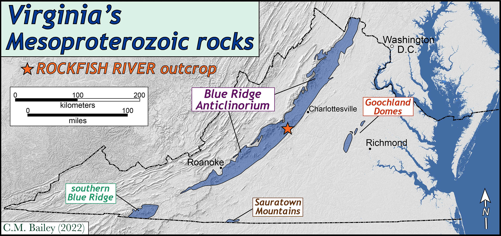
Map illustrating areas in which the Mesoproterozoic basement rocks crop out at the surface in Virginia.
Mesoproterozoic rocks in Virginia are primarily metamorphosed igneous rocks that formed during the Grenville Orogeny, an epic tectonic event that created a supercontinent and reshuffled the Earth’s geography in a major way between 1.2 to 1.0 billion years ago. A billion years ago the world was a different place as life was transitioning to proper multicellular organisms among whom sexual reproduction became both fashionable and successful.
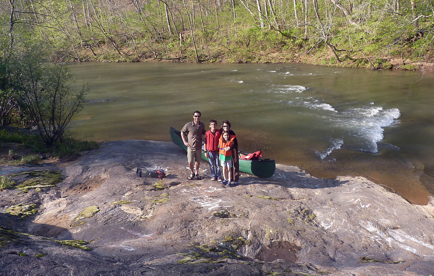
My family about to launch a canoe onto the Rockfish River from this outcrop (Spring 2011).
This post focuses on an exceptional outcrop of Mesoproterozoic basement rock exposed along the Rockfish River in Nelson County, some 35 kilometers (22 miles) southwest of Charlottesville. I’ve visited this outcrop with William & Mary students for more than 25 years, and it’s also a fine place to launch a canoe on to the Rockfish River for a refreshing paddle.
In the past few years, the quality and character of this exposure has suffered from both natural and human processes which conspired to obscure the outcrop’s fabulous features. Virginia’s climate is not ideal for the longevity of bedrock outcrops as rocks undergo considerable mechanical and chemical weathering which inevitably produce regolith and soil that degrades or covers up the bedrock. Bedrock outcrops are also the battlefield upon which primary plant succession is waged.
Compare these pictures of the outcrop taken ~25 years apart.
1996
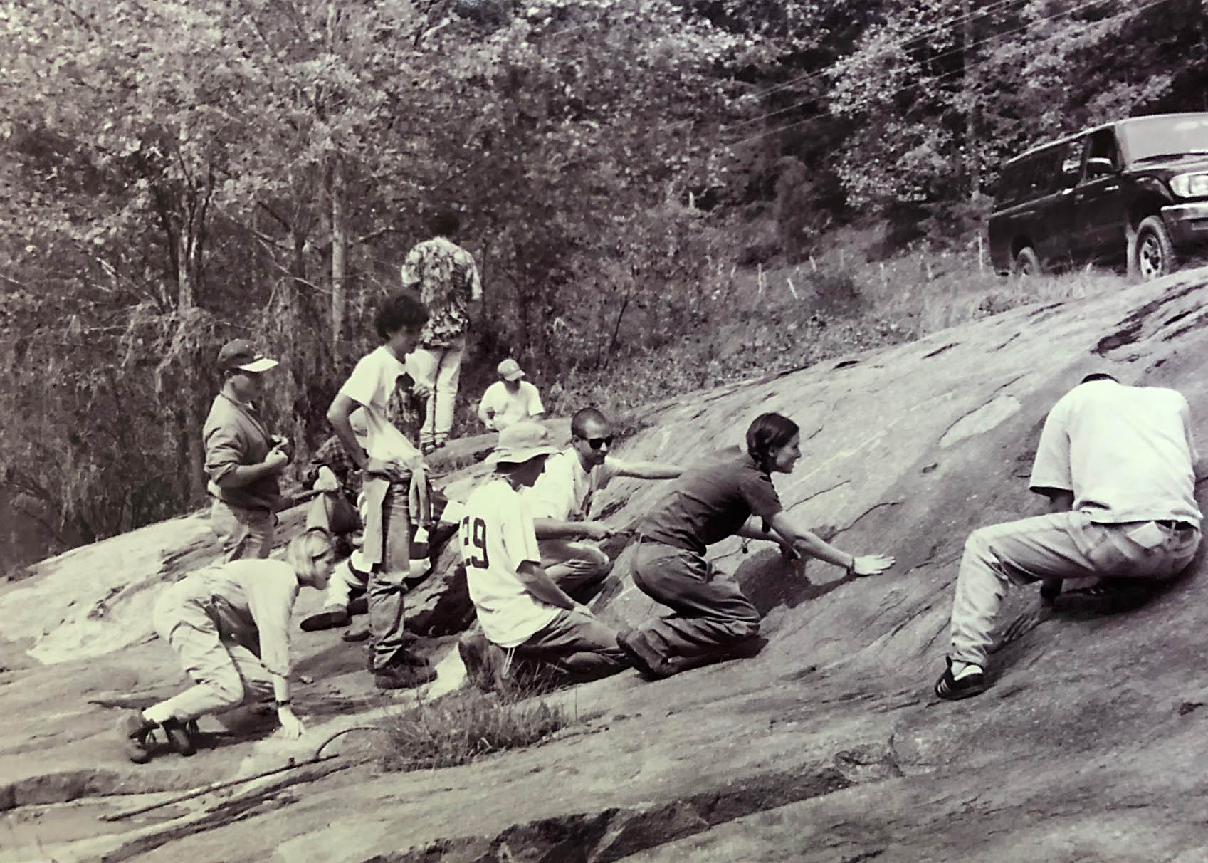
William & Mary geology students intently examining the outcrop.

A close-up view of the outcrop with nearly 100% exposure illustrating two major rock types: biotite granitoid gneiss (dark gray) and granite (white) plus some interesting geological structures.
2021-22
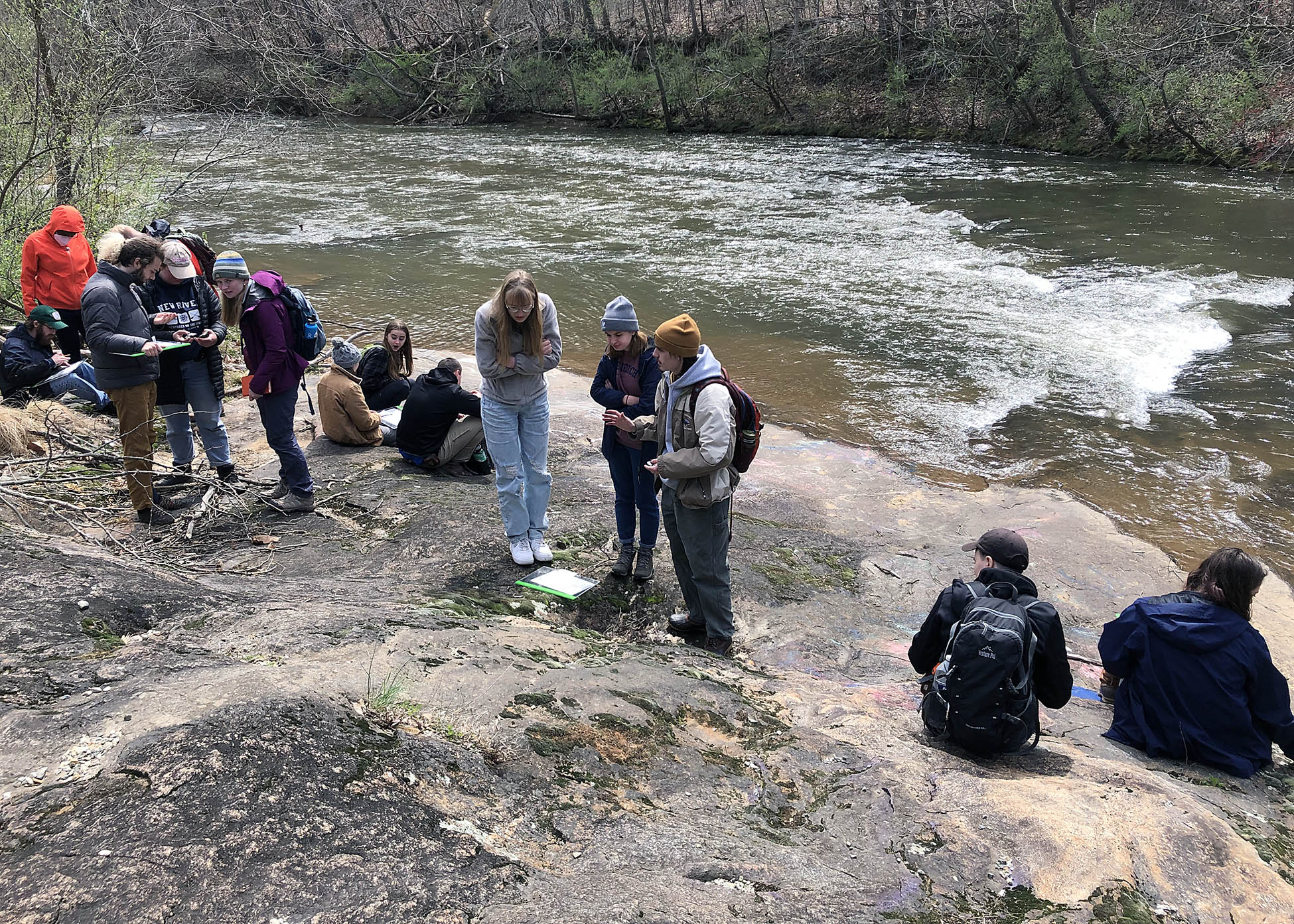
William & Mary geology students intently examining the outcrop.

Schuyler Sisters, Haley Meyrowitz and Terri Zach, survey the outcrop. Can you find the close-up location from the 1996 photo in this image?
The Earth’s surface is a complicated place, as some surface processes erode and remove material (collectively we’ll call these processes Pe), whereas other processes weather, alter, and cover over materials (these we’ll call these Pc). When Pe>Pc, bedrock is exposed at the surface, but when Pe<Pc the bedrock is not exposed and typically mantled by sediment, soil, and/or saprolite.
Outcrops along rivers and streams are interesting places because they are locations at which the processes that expose and erode underlying bedrock are clearly at work. For instance, the erosive power of flowing water, especially at high water, can remove regolith and strip away vegetation from the riparian area. If you like bedrock outcrops erosion is a good thing.
However, fluvial processes can also deposit sediment which covers the bedrock. Ample moisture in these environments helps to facilitate the growth of cyanobacterial and algal biofilms on outcrop surfaces which enables organic matter to accumulate and leads to bioweathering of minerals beneath the film. Thin biofilms may be replaced by macroscopic patches of lichen while in crevices, along cracks, and in damp spots moss may grow. Collectively, these biologically driven processes work to cover the outcrop surface.
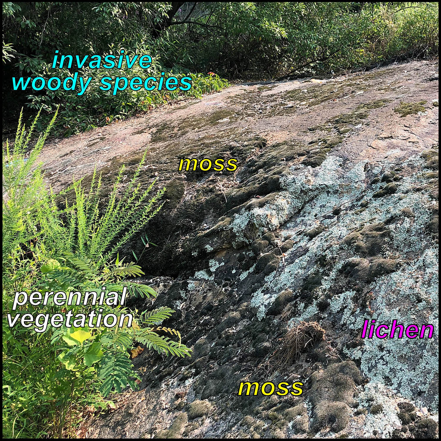
2021 photo with plentiful vegetation, moss, and lichen coercing the outcrop surface.
In the 1990s, this outcrop was mostly clean with small patches of lichen and moss with a few tufts of grass growing out of the larger low spots on the outcrop. However, over the past 25 years, the outcrop has become significantly degraded as the biogenic patina of microbes, lichens, and moss have greatly expanded their territory and in the process covered up some spectacular geology. Furthermore, along the edges of the outcrop invasive woody species, in particular Autumn Olive (Elaeagnus umbellata) have gained a foothold, grown like weeds, and expanded onto and over the outcrop.

2021 photo showing graffiti and the dark staining from biofilms growing on the outcrop surface.
This outcrop is a popular spot for relaxing and cooling off in the Rockfish River (as well as for tossing back a few cold drinks). Over the years, some of these merrymakers have spray painted their artistic vision on the outcrop and this graffiti also hides the underlying geology.
As noted above, a bedrock stream channel is a dynamic environment and one in which we might expect that the processes that transport material as well as erode earth materials to be effective. But most erosion and channel change occurs during high-flow events (floods). The bigger the flood, the greater the potential for change. Over the past 80 years, the Rockfish River has flooded many times.
In 1969, the remnants of Hurricane Camille caused tremendous flooding along the Rockfish River with a peak flow of ~70,000 cubic feet per second (cfs)1. That 1969 flood completely thrashed the Rockfish River valley as it washed away houses, roads, and bridges. Although the 1969 event is an outlier, other high flow events erode sediment, carry away vegetation, and expose bedrock. However, the last significant flood event along the Rockfish River, one that exceeded 10,000 cfs, occurred in 1996 during Hurricane Fran.
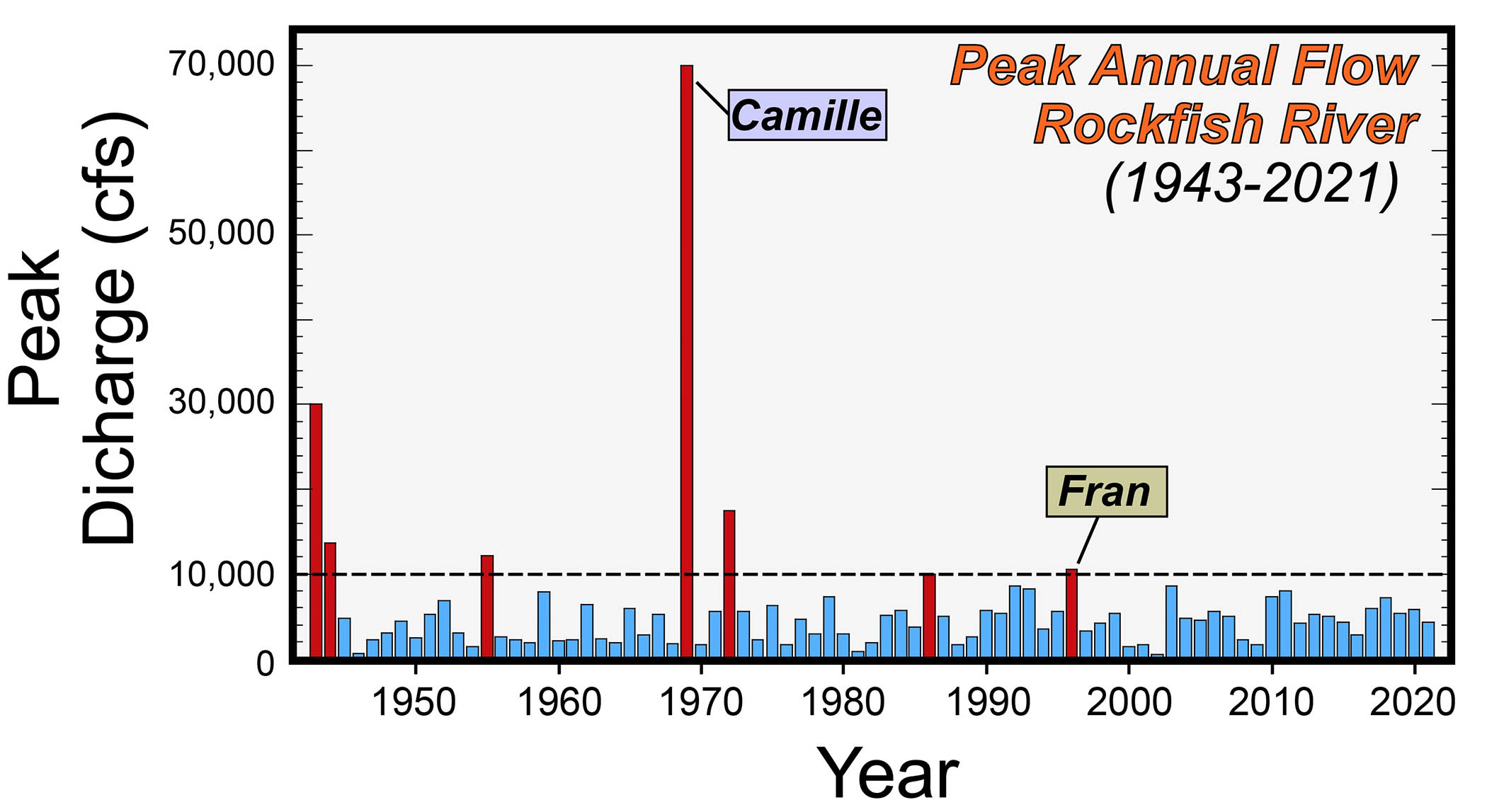
Time series of peak annual flow on the Rockfish River. Note there have been no flows of >10,000 cfs (cubic feet per second) since 1996. Data from the U.S. Geological Survey.
In the past 25 years there have been no big peak annual flows along the Rockfish River. The lack of really high flows has no doubt contributed to the success and expansion of microbes and vegetation at the expenses of the outcrop. Big floods rip out vegetation and transport sediment, without high-volume vigorous flows these vegetation communities have expanded their turf.
After this year’s Earth Structure & Dynamics field trip, in which the class struggled to see fresh rock or even find the important structures at this outcrop, I decided enough was enough. It was time to restore this exposure to its former glory by power-washing the outcrop.

William & Mary geologists (from left to right) Zack Price, Selwyn Heminway, and Claire Moravitz struggle to see past the moss and lichen on the Rockfish River outcrop (March 2022).
Over the past five years, we’ve used a power-washer on other outcrops with some success. For a power-washer to do its job it needs to be fed a steady flow of water and that can be a challenge in various field settings. Geology senior Zach Price, and one of the B to the 7th research team, figured we should put a submersible pump in the river and pump water into the power-washer. That required not only a pump, but a portable generator to kick the whole thing into motion.
Last week, on a hot August morning, Zach and I hitched up all the respective pieces, pulled the starter ropes on our machines, and let it rip! Two hours later our power-washing produced noticeable results. Later in the afternoon, when the sun was in an optimal position, we flew my drone to get some aerial imagery and see what our labors had wrought.
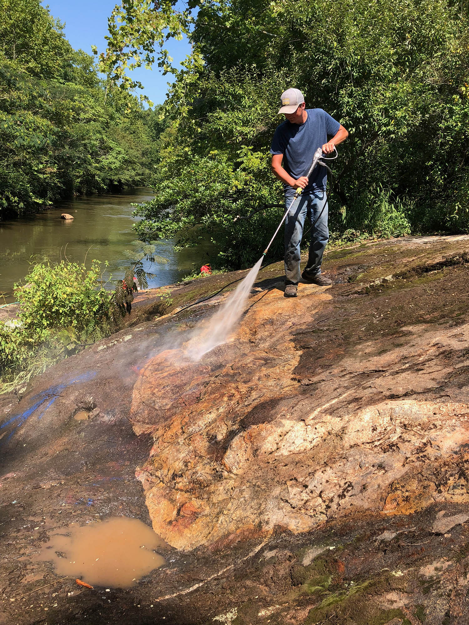
William & Mary geologist Zach Price brings the power to an outcrop along the Rockfish River.
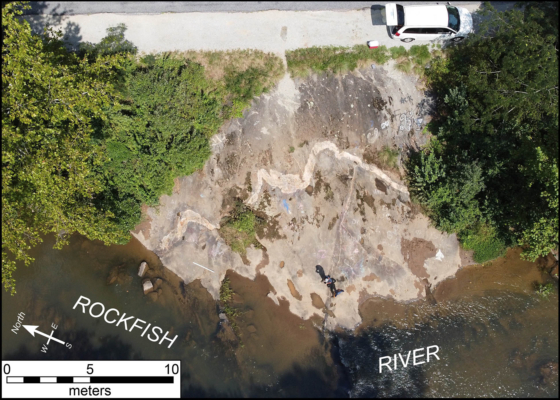
Annotated aerial image of the outcrop along the Rockfish River after our power-washing endeavor.
Pumping water from the river worked well and most of the water was returned right back to the river. We power-washed ~40 m2 of the outcrop and focused on re-exposing the contact between the distinctive light-colored granite and the dark gray biotite-bearing granitoid gneiss. The moss was particularly tenacious and tough to remove as were the spray-painted surfaces. Our aerial imagery reveals that we made progress, but there’s still more power-washing that’s required to fully bring these Grenvillian rocks back to their former greatness.
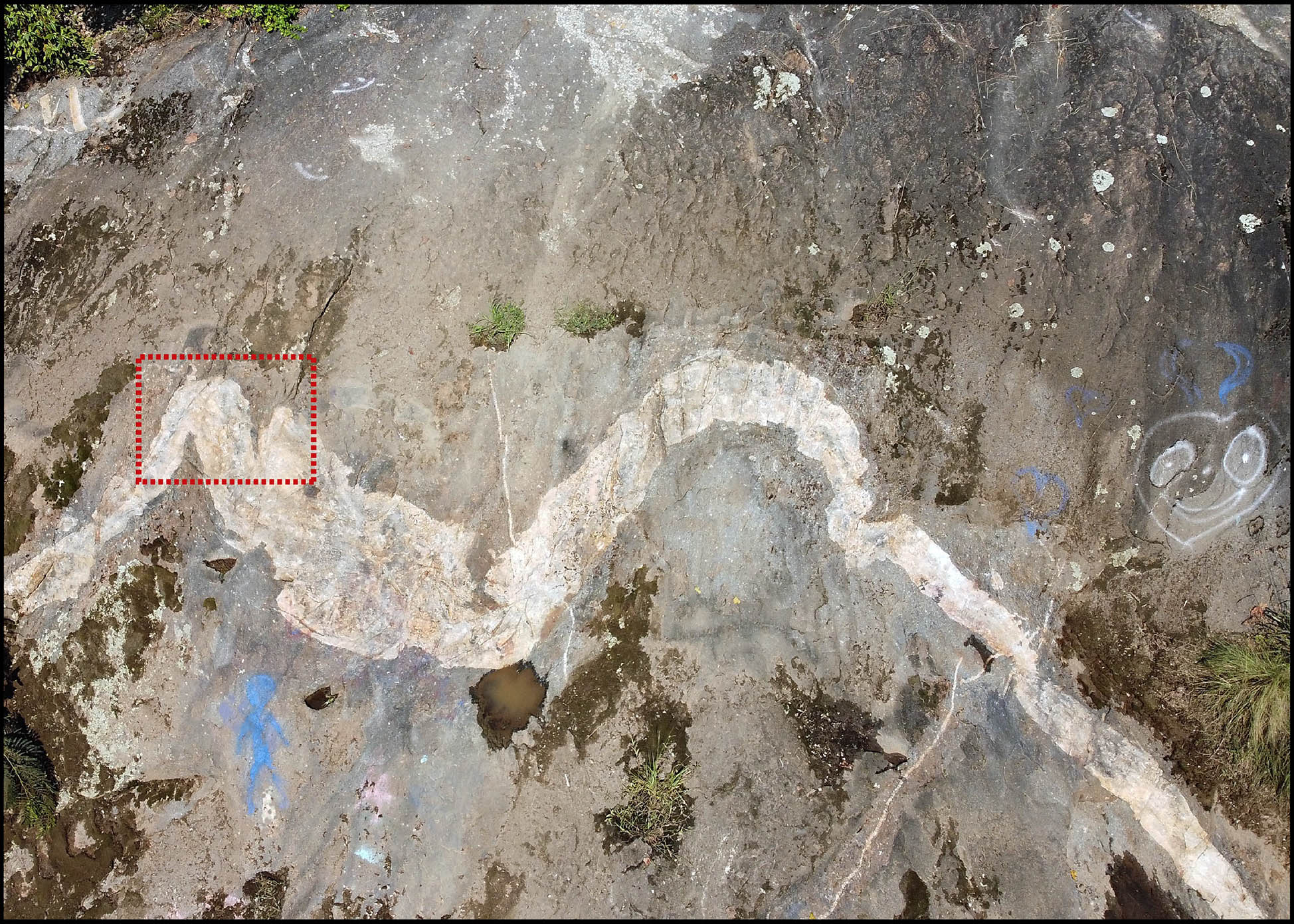
Close-up aerial image. Our power-washing re-exposed much of the light-colored granite. The rectangular dashed box is the area illustrated in the 1996 photo. There is more power-washing to do as some areas are still covered with a dark biofilm, lichen + moss, other vegetation, sediment, and graffiti.
Our power-washing foray destroyed whole ecosystems that had successfully colonized the outcrop. Death to the colonizers! Indeed, we wreaked havoc on these ecosystems, but life on a bedrock outcrop at the river’s edge is one of opportunity and precarity.
I’d argue we have a responsibility to preserve and celebrate this outcrop as it’s part of Virginia’s geological heritage. Given its location, ease-of-access, and world-class structural features the outcrop should be preserved for research and future study.
Geological heritage (or geoheritage) is a concept that’s gained traction over the past two decades. The U.S. National Park Service notes:
Geologic Heritage encompasses the significant geologic features, landforms, and landscapes characteristic of our Nation which are preserved for the full range of values that society places on them, including scientific, aesthetic, cultural, ecosystem, educational, recreational, tourism, and other values. Geoheritage sites are conserved so that their lessons and beauty will remain as a legacy for future generations.
Such areas generally have great potential for scientific studies, use as outdoor classrooms, and enhancing public understanding and enjoyment. Geoheritage sites are fundamental to understanding dynamic earth systems, the succession and diversity of life, climatic changes over time, evolution of landforms, and the origin of mineral deposits.
I completely agree with this statement. Working with William & Mary students, other geoscientists, and local organizations we’ll continue to restore, preserve, and document exceptional Virginia outcrops. As we make progress, I’ll bring the highlights of those efforts to my blog posts.
Footnote
1the U.S. Geological Survey gauging station is located about 5 km (3 miles) upstream from this outcrop so peak flows here are likely higher than reported in that data set.


Comments are currently closed. Comments are closed on all posts older than one year, and for those in our archive.
Love it! Nice work! Discovering one geologic gem of Virginia one at a time..we out here putting in work!
I love your writing so much. “A billion years ago, when sexual reproduction became both fashionable and successful.” Mic drop.