
Williamsburg’s Grand Canyon: A Modern Marvel Created by Mismanaged Stormwater
Many William & Mary students and some long-time residents describe Williamsburg’s landscape as flat, swampy, and even boring. Indeed, parts of this landscape are flat, and the bottomlands may be swamps (a forested landscape with standing water). But, for those suggesting that the local terrain is all together boring, I suggest a visit to Williamsburg’s Grand Canyon located in the College Woods just a short distance to the west of campus. This ignoble gorge occurs in the headwater reaches of Strawberry Creek, a tributary of Lake Matoaka.
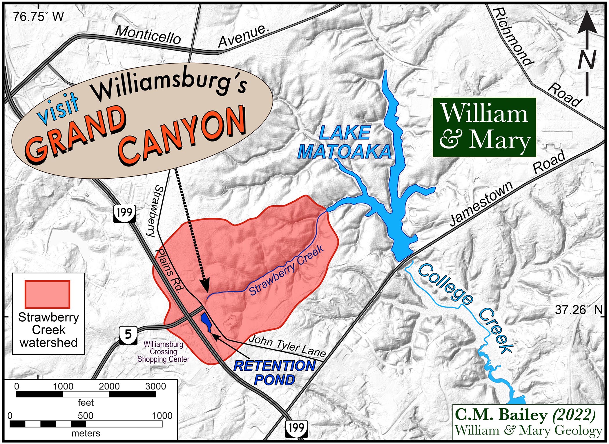
Location map of Williamsburg’s Grand Canyon in the Strawberry Creek watershed. Note the retention pond, Rt. 199, and the Williamsburg Crossing Shopping Center. Click on the map for a larger image.
This canyon, carved into the sandy sediments of the Atlantic Coastal Plain, is more than 8 meters (~25’) deep with near-vertical walls that make entry into or exit from it challenging. The gorge is narrow enough that the rays of the midday sun rarely reach to the valley floor. Along the canyon walls, trees occur in topsy-turvy fashion, some with water sprouts growing at odd angles up and away from the mother trunk. It’s a stunning and geologically curious landscape.
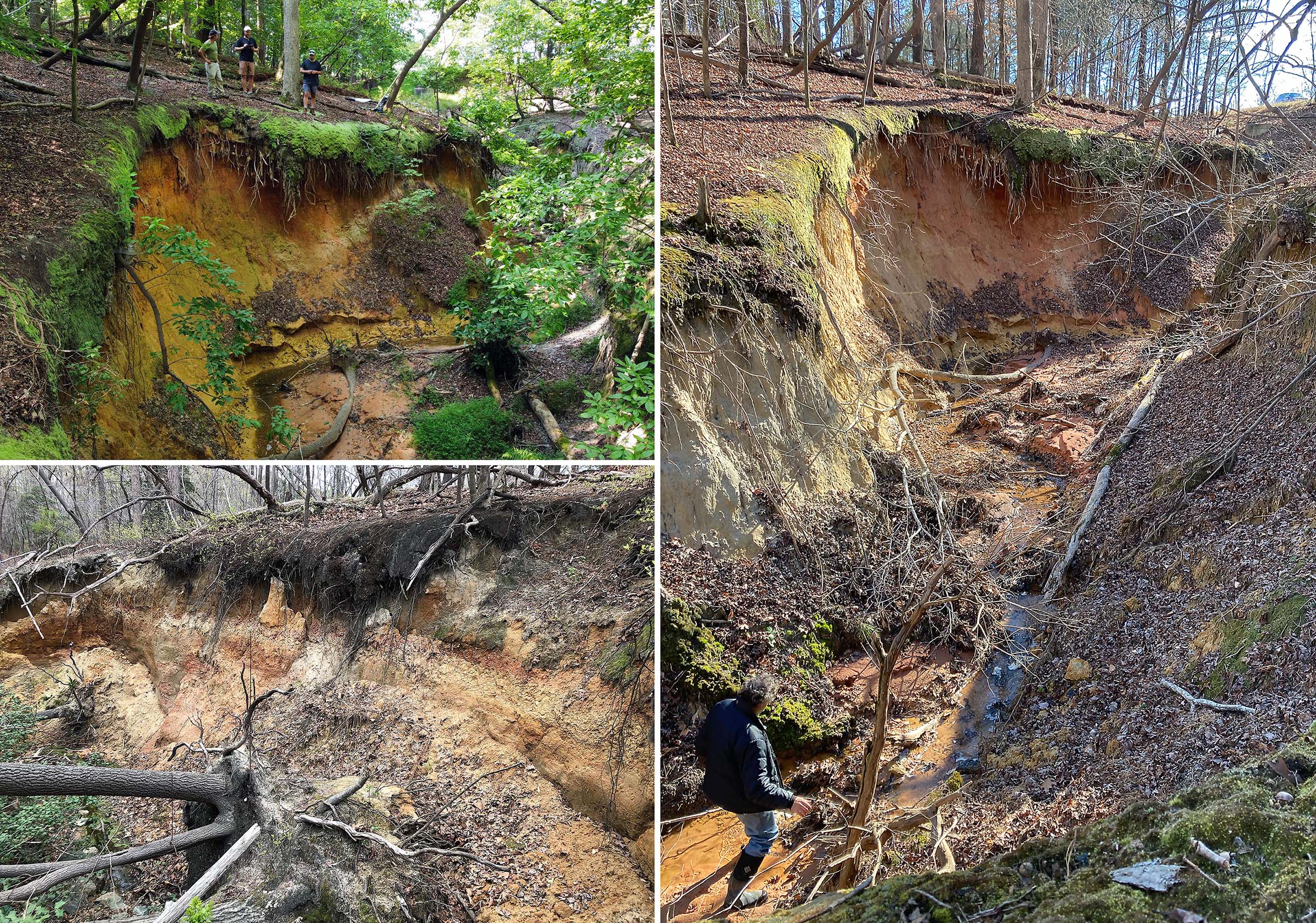
Montage of Williamsburg’s Grand Canyon. Top left – drone photo of the canyon, note people on the canyon’s rim. Bottom left – tilted trees with an attached root ball on the canyon wall. Trunk of the largest tree is ~30 cm (1 ft) in diameter. Right – a brave explorer on the canyon floor. Select the image for a bigger view.
In most Coastal Plain watersheds, the upper reaches of stream valleys are broad and shallow with only a small ephemeral channel in the valley bottom. But in the upper reaches of Strawberry Creek, there is a well-defined channel occupying the bottom of a steep U-shaped valley.
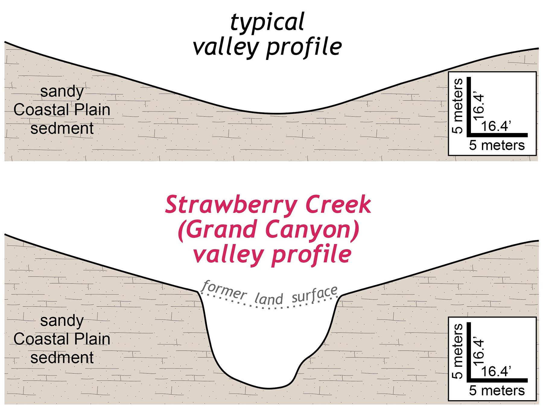
Cross section comparison between a typical Coastal Plain upland valley and the Strawberry Creek valley/canyon.
What’s going on here? How did this dramatic gorge form?
Williamsburg’s Grand Canyon is the product of erosion. Lots of erosion is occurring in the headwaters of Strawberry Creek and it’s happened in an instant of time, geologically speaking. Here the stream has vigorously incised into its existing valley, lowering the land surface by 5 to 8 meters (16-25’) thereby creating the gorge. The erosion rate is also remarkably high as evidenced by the tilted and tipped over trees that have fallen into the abyss as well as the unvegetated and bare earth walls of the canyon.
Based on detailed topographic data from a 2014 LiDAR survey we can determine the ‘current’ profile of Strawberry Creek and work backwards to what the stream profile was prior to this interval of dramatic erosion.
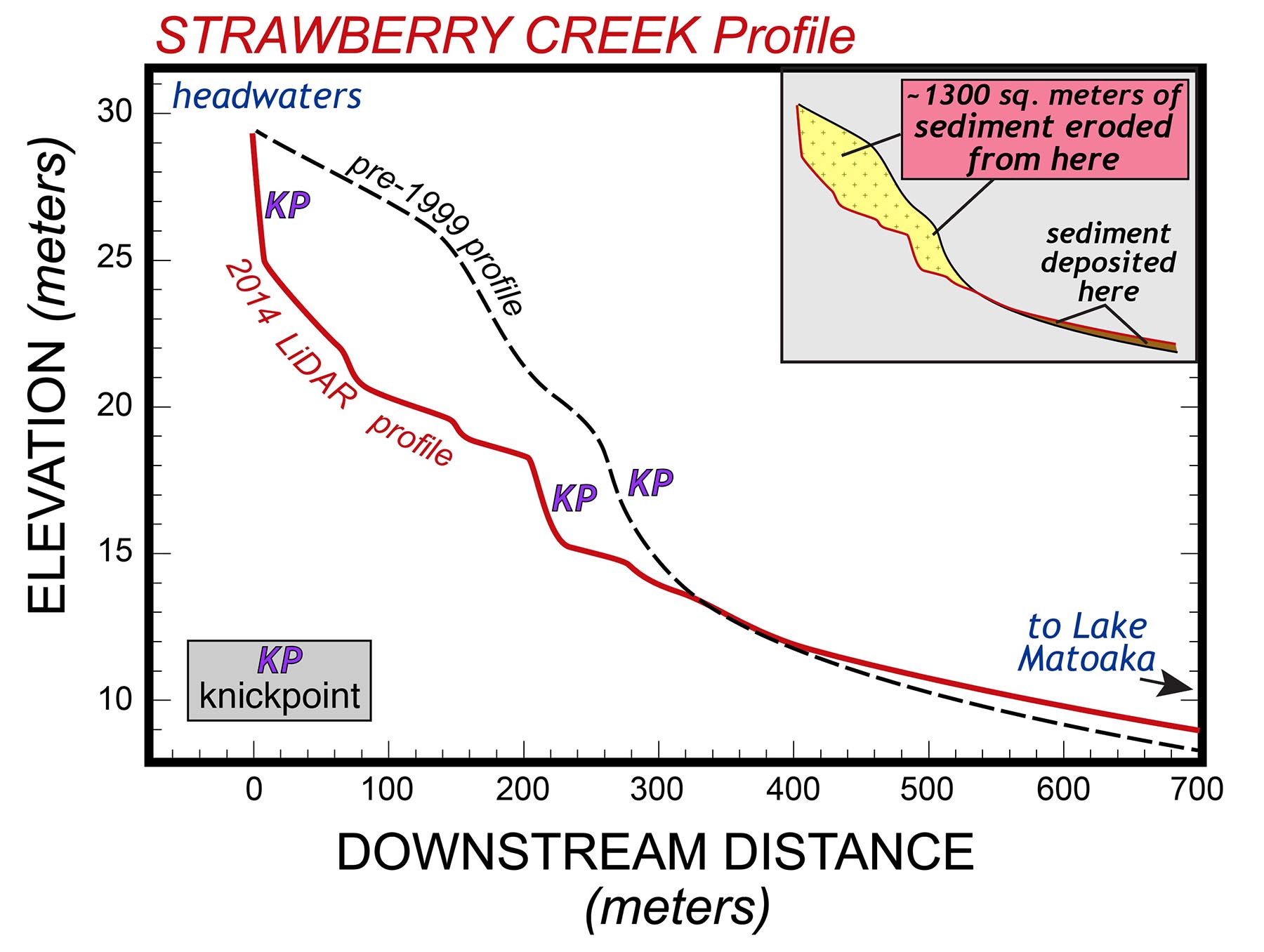
Strawberry Creek stream profile based on 2014 LiDAR topographic data and pre-1999 profile. Inset shows areas of erosion and deposition. Knickpoints are reaches of steep gradient along the stream.
In the upper 300 meters (1,000’) of Strawberry Creek there’s been a significant lowering of the channel (the dashed black to red line) since 1999. We can estimate (in 2-dimensions) the amount of erosion that’s occurred by determining the area between the two stream profiles (the yellow polygon in the inset) and dividing that by the channel distance over which erosion occurred.
1300 m2 of material eroded over 300 m of channel distance
= 4.3 meters (14’) of erosion
Since we know the time interval between the two profiles, let’s calculate an average erosion rate.
4.3 meters of erosion /15 years = 0.3 meters /year (1 foot/year)
Whoa! At Williamsburg’s Grand Canyon, the earth’s surface has been lowered, on average, by nearly 1 foot per year. That’s extreme erosion.
To put that into perspective. The more famous Grand Canyon, the one in Arizona which the W&M Geology department visits on our field course to the American West, is a tremendous landform that’s nearly a mile deep. It’s also a geological oddity because it formed quickly, by geological standards over the past 5 million years. That averages out to an erosion rate of ~0.3 mm per year (about an inch per decade). The erosion rate in the headwaters of Strawberry Canyon is 1,000 times faster than at the Grand Canyon– something is definitely out of whack.
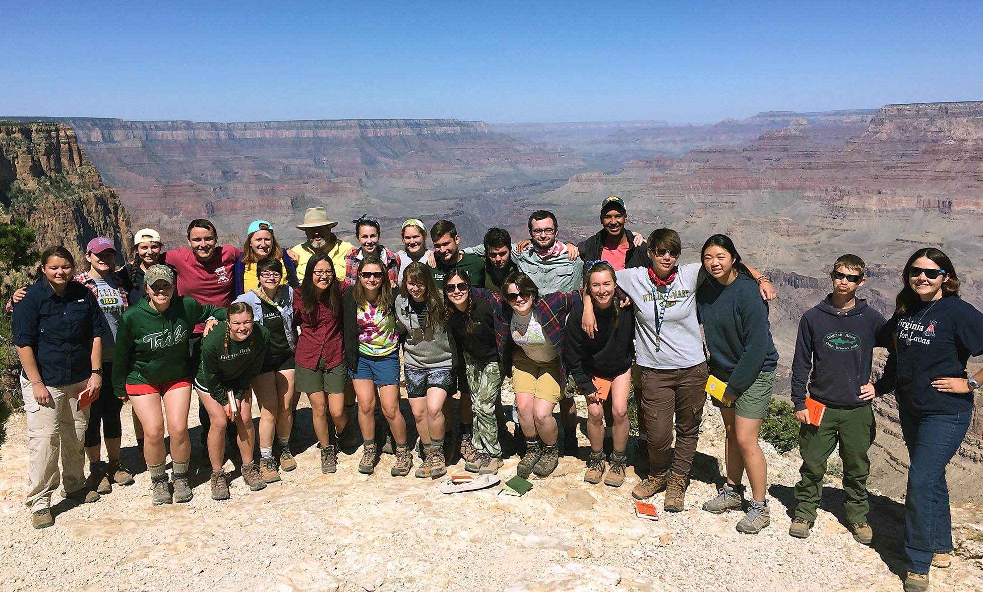
William & Mary geologists at the rim of the Grand Canyon back in 2016 on the Geology 310 – Regional Field Geology course.
Where does all the eroded sediment from Williamsburg’s Grand Canyon go? The simple answer is that the sediment goes downstream. As the channel gradient lessens, much of the sediment is deposited as sand/silt in the lower reaches of Strawberry Creek with some of the finer-grained sediment reaching Lake Matoaka. An over-abundance of sediment is a form of pollution. So much sediment is being deposited in the lower part of Strawberry Creek that tree trunks are being covered by aggrading sediment which alters the riparian ecosystem in bad ways. This includes the loss of understory biodiversity and the invertebrate fauna, the burial of existing seed banks, and the degradation of water quality – all of which can accelerate ecosystem change and provide opportunities for invasive species to encroach.
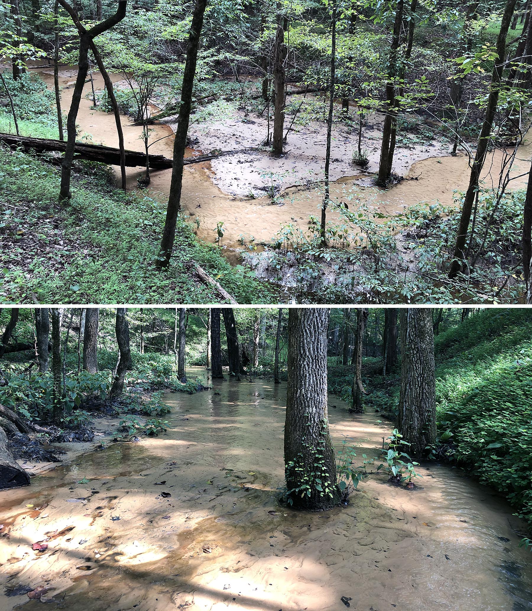
Sediment pollution in the lower reaches of Strawberry Creek. Top – recently deposited sediment along the aggrading floodplain. Bottom – the base of tree trunks buried in sediment; at some locations the sediment is 0.6 meters (2’) thick.
What would cause Strawberry Creek, originally a modest and mild-mannered tributary stream to Lake Matoaka, to carve such a canyon?
A significant increase in stream flow or discharge (flow volume per time) can cause mild-mannered streams to do unthinkable things. With increased discharge, a stream does more geomorphic work – effectively the stream has more power to transport and erode materials in its channel.
Why might discharge have significantly increased in Strawberry Creek?
The Williamsburg landscape has witnessed great change over the past hundred years. In the early 20th century, Williamsburg was a sleepy college town surrounded by rural countryside, primarily a mix of woodlands and small farms. By the late 1950s, the area had started to grow as it became a destination for tourists and transplants. Intense suburban growth took off and has continued into the 21st century. Farms and wood lots have been replaced with subdivisions, pavement, and centers of commerce.
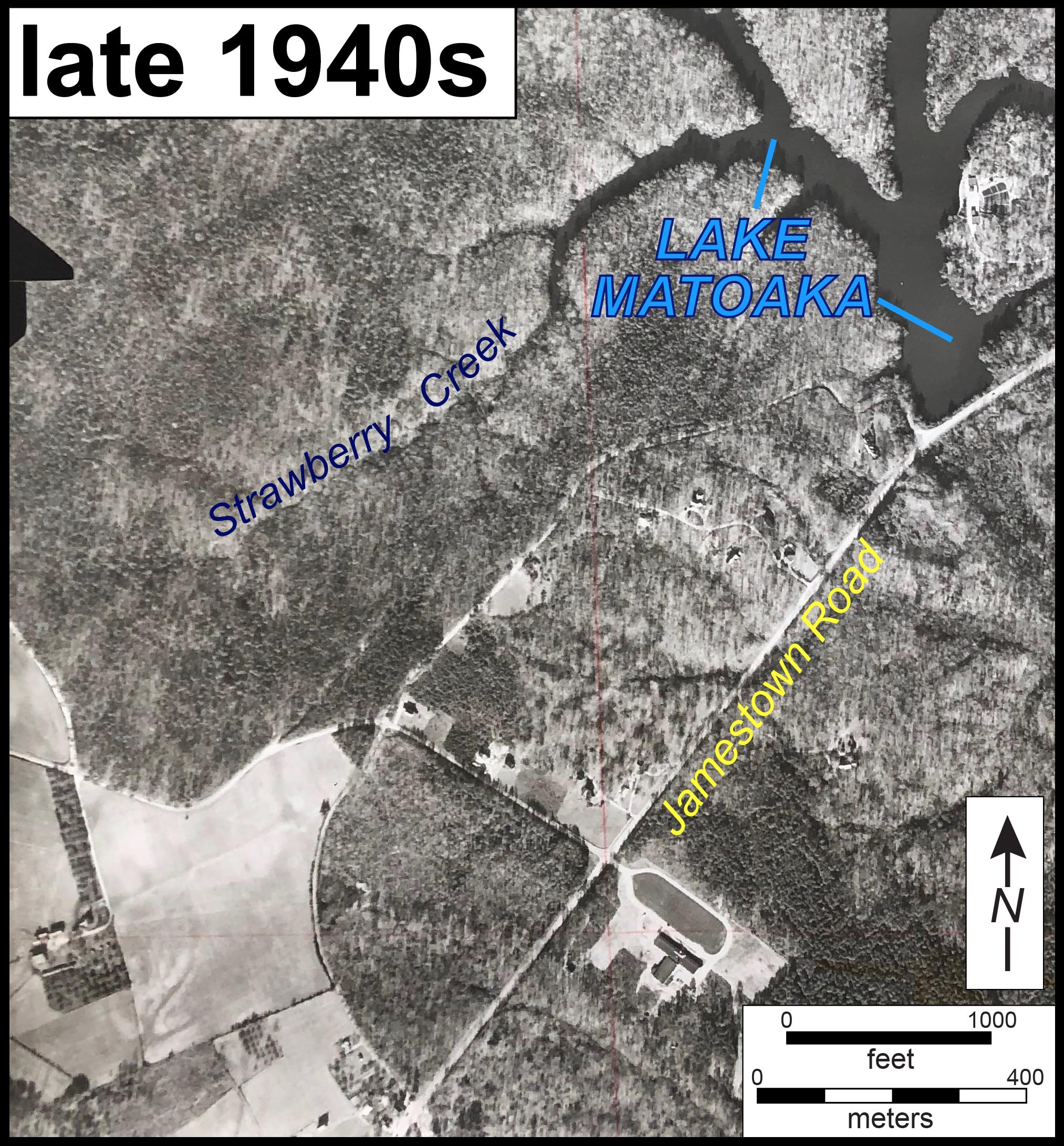
Aerial imagery from the late 1940s with farmland and woodlands. Note Lake Matoaka and Strawberry Creek.
Compare the late 1940s aerial photo to the 1994 imagery. Fortunately, Lake Matoaka and the College Woods have escaped development, but there’s been much suburban development in Strawberry Creek’s catchment. The Williamsburg Crossing shopping center, developed in the 1980s has a large footprint just west of the Strawberry Creek watershed.
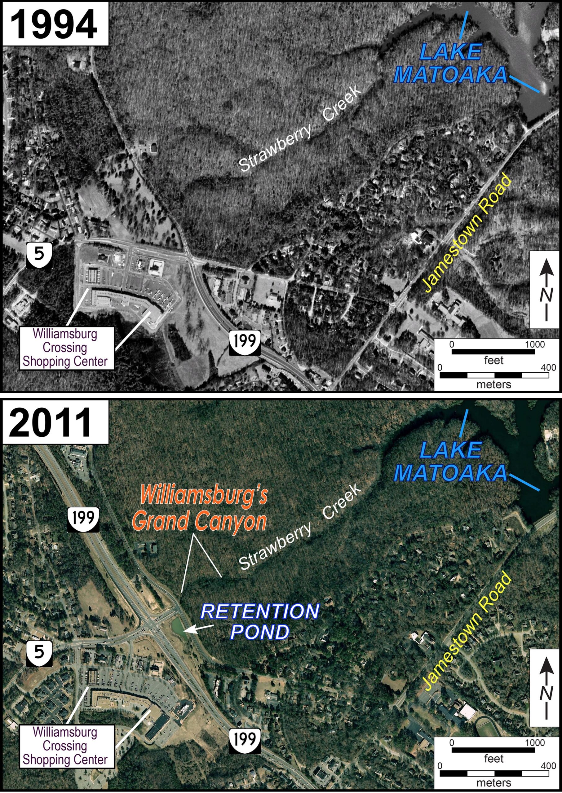
Google Earth imagery from 1994 (top) and 2011 (bottom). Rt. 199 and the retention pond were completed in 1999.
In 1999, the Virginia Department of Transportation fully opened Route 199, a 4-lane highway that conveys traffic around Williamsburg’s west and south sides. As part of this project, a 1-acre storm water retention pond was constructed between Rt. 199 and Strawberry Plains Rd./ John Tyler Lane. This particular retention pond releases its outflow into the upper reaches of Strawberry Creek.
Retention ponds are intended to mitigate rapid runoff from parking lots, roads, and buildings – effectively capturing storm runoff in a storage pond that then is slowly discharged out to streams. Ideally, these ponds lower storm runoff as well as trap sediment and pollutants. Retention ponds are legislatively mandated in modern developments and commonly referred to as a ‘best management practice’ for storm water. But are they really?
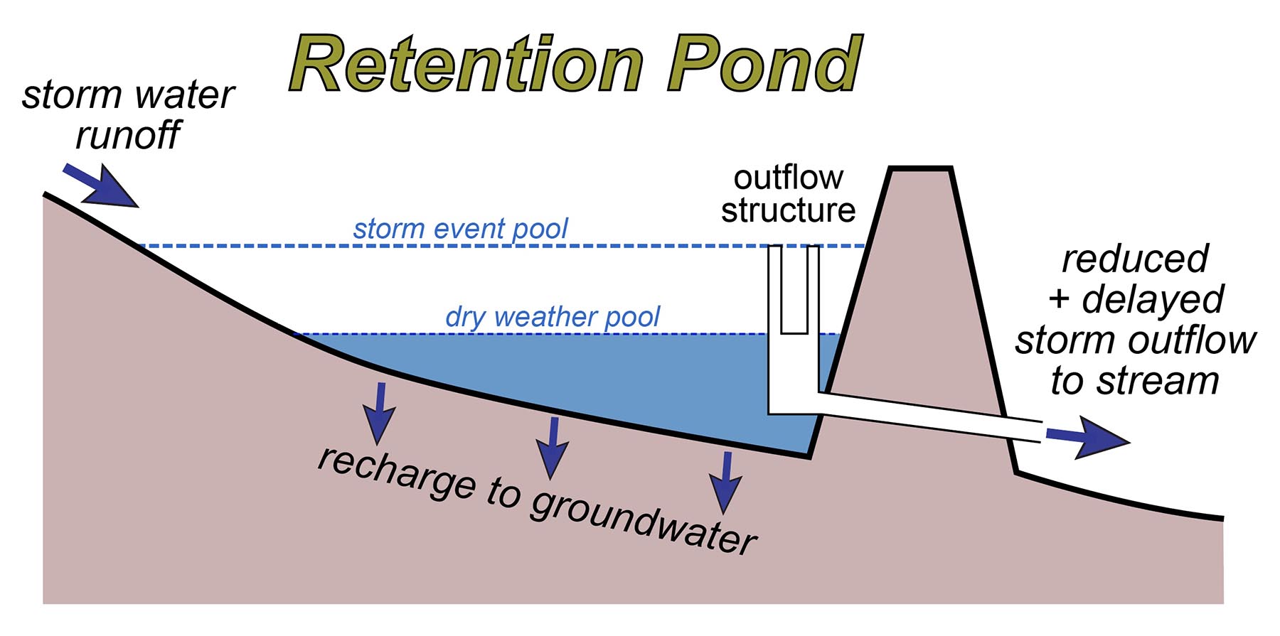
Schematic illustration of a storm water retention pond.
This retention pond, built to mitigate runoff and pollution has done just the opposite. During precipitation events, significant volumes of water are released from the retention pond via an outflow pipe that takes the water under John Tyler Lane to a ~1-meter (3’) diameter outlet at the head of Strawberry Creek.
The Grand Canyon of Williamsburg begins at a massive drainpipe. During storms this pipe disgorges far more water into Strawberry Creek than would naturally occur. Furthermore, construction of Rt. 199 altered the terrain, effectively changing the watershed boundary such that areas west of Rt. 199 and at the shopping center (not originally in the Strawberry Creek watershed) were plumbed so that runoff goes to the retention pond.
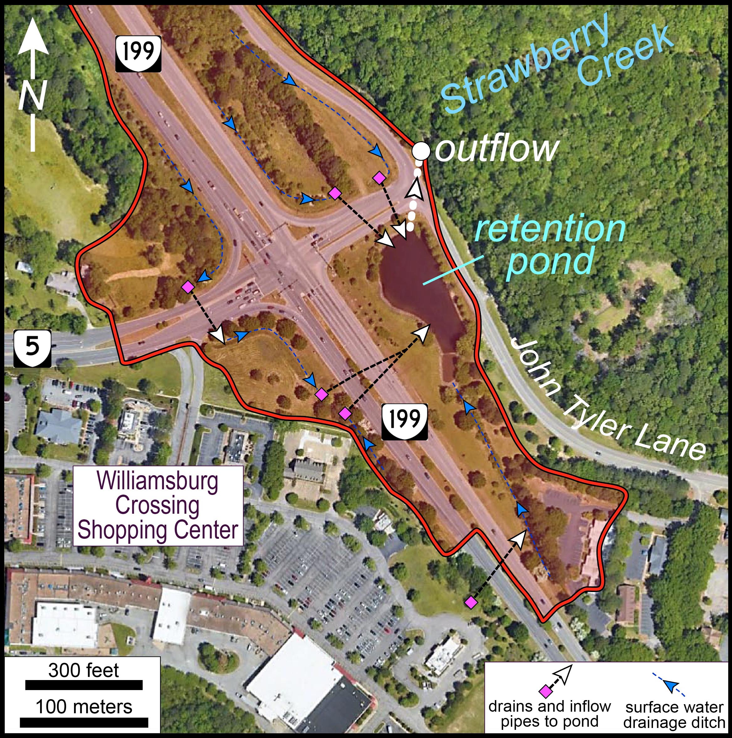
Map of the drainage basin that feeds the retention pond (red polygon) which outflows to Strawberry Creek. Nearly 40% of the retention pond’s drainage area is impermeable such that runoff is quite high.
Excess discharge from the retention pond has increased the stream power of Strawberry Creek, which in turn has vigorously eroded into its channel and incised the landscape.
In 1999, prior to the opening of Rt. 199 and the construction of the retention pond, there was no Grand Canyon of Williamsburg. Back then, the headwaters of Strawberry Creek were unremarkable and similar to many other small watersheds in the area.
Williamsburg’s Grand Canyon formed in under two decades – it’s definitely a modern marvel!
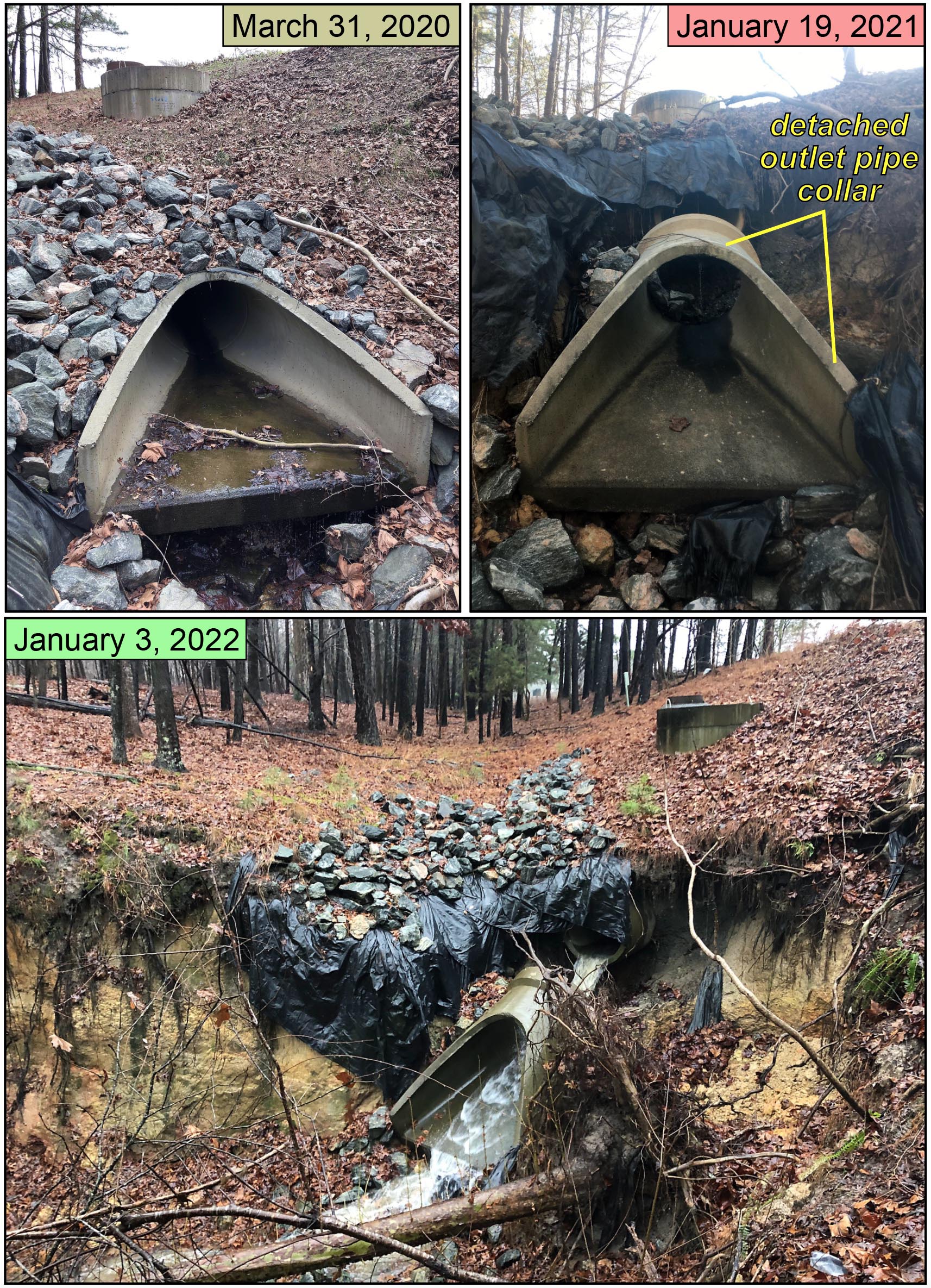
The outlet pipe at the head of Strawberry Creek. On March 31st, 2020 the outlet pipe collar was intact and surrounded by coarse-grained stone to protect against erosion. Less than 10 months later (January 2021) the outlet pipe collar was detached from the pipe. This is not a pretty sight. Bottom photo illustrates the situation during a moderate precipitation event in early 2022. Select the image for a larger view.
During storm events, the amount of water that courses from the outlet pipe is tremendous. In March 2020, the pipe outlet collar looked firmly anchored into the slope, but less than 10 months later it had become detached. In a case of too little-too late, the terrain around and above the pipe had been covered with a plastic liner overlain by coarse stone, collectively intended to armor and prevent headward erosion of the slope. It’s not working, and the headwaters/outflow pipe area might be best described as a ‘hot mess’.
A big storm event, something like a tropical storm delivering 20 to 25 cm (8 to 10 inches) of precipitation, could trigger erosion such that the canyon wall cuts back enough to cause a massive failure at the 3-way intersection of John Tyler Lane, Strawberry Plains Road, and John Tyler Highway (Rt. 5). That might attract some attention.
Video of the outflow pipe and upper reaches of Strawberry Creek during a moderate rainfall event on January 3rd, 2022.
During the pond’s construction, Professor Jerre Johnson wryly noted “this pond is not going to work, it’ll do more damage than good.” Jerre had a keen eye for the practical, yet as a geologist (rather than say, an engineer) he rarely got much traction with the powers that be.
In 2010, my colleagues Greg Hancock and Randy Chambers published an interdisciplinary study in the Journal of the American Water Resources Association which focused on the efficacy of retention ponds and their downstream impact in the Williamsburg area. Over a four-year study period, they found that 4 out of 5 retention ponds in James City County consistently failed to meet their design goal of delaying the 1-year event stormflow downstream. The widespread failure of stormwater retention ponds at protecting streams in suburban Virginia is one of the principal reasons why the Chesapeake Bay is impaired by pollution and its fisheries resource is declining.
Joanne Ensley’s (W&M Geology ’19) thesis focused on the retention pond and its impact on Strawberry Creek. Her study confirmed that outflow from the pond significantly impacts the temperature and stream chemistry of Strawberry Creek in negative ways.
This coming semester, Professor Dom Ciruzzi and his hydrology class will start new research in Strawberry Creek quantifying water movement through this perturbed landscape and disturbed ecosystem. Research opportunities abound at the Grand Canyon of Williamsburg.
Summary
Williamsburg’s Grand Canyon is the result of extreme erosion caused by increased stream discharge – a consequence of a poorly designed/engineered retention pond and its inflow/outflow network. It’s ironic that a ‘best management practice’, intended to mitigate environmental harm, is responsible for two decades of riparian ecosystem damage in the College Woods. If erosion on this scale had chewed up the landscape in a neighborhood, a shopping center, or a park it’d be different story; one full of lawsuits resulting in costly damage awards and likely substantive investment for environmental remediation.
So, what now? It’s unlikely that we’ll turn Rt. 199 back into forest or regrade the landscape to its original contours. A rational course of action would involve raising the pond’s outlet thus keeping more storm water in the retention pond for a longer period of time – basically getting the engineering design right. The base of the retention pond contains an impermeable liner added to support aquatic vegetation which prevents water from percolating out through the bottom of the pond. From a stormwater management perspective this was exceptionally misguided. A remedy would be making the pond more permeable by drilling holes through the liner thereby increasing recharge and lowering outflow.
However, I’m not optimistic that positive change will be forthcoming, and we cannot put the eroded sediment back. The lesson here is that urbanization and development significantly damage the local environment and need to be done sparingly with careful and thoughtful planning. Stormwater retention ponds are not a simple solution that mitigates the environmental cost of urbanization.


Comments are currently closed. Comments are closed on all posts older than one year, and for those in our archive.
We’re gonna need a bigger pipe!
commas looking good
Wow, 4/5 retention ponds failed in WJCC… and the only thing we keep doing is urbanizing.
Wow, this is a great article! Written so a layperson like me can understand. It’s daunting to think of how to best mitigate the damage and sad to consider the harm that this has already done. Thanks for making the problem so easy to understand even if it’ll be hard to fix.
Say “Ignoble gorge” 5 times fast.
This article is really insightful and helpful for understanding the hydrology of Strawberry Creek. It is also incredibly helpful for my thesis so thank you very much for sharing!