Let It Rain
I’m teaching Weather, Climate, & Change (pdf) – a COLL 100 course – to 40 enthusiastic students who are in their first semester at W&M. Nearly every day in class, I play the Song of the Day — it’s a musical interlude intended to add some rhythm to class (literally), and the song lyrics connect, in some way, to what we are discussing. Here’s a sampling of some of what’s been played thus far: Blue Sky by the Allman Brothers Band, Under Pressure by Queen and David Bowie, Cyclone by Baby Bash, and the Tide is High by Blondie. I’ve been eager for the opportunity to play Let It Rain by Eric Clapton, but we’ve had no rain to speak of since the semester began, and Slowhand is patiently waiting his turn to appear in class.
 In the past month we’ve received a scant 1 cm (~0.3 in.) of precipitation on campus. It’s been dry in Williamsburg. The tulip poplar trees are steadily dropping their dried and worn out leaves, yet summer still has its hot and humid grip on us. A week ago there was much anticipation about Hurricane Hermine, but her rain bands never quite got to Williamsburg.
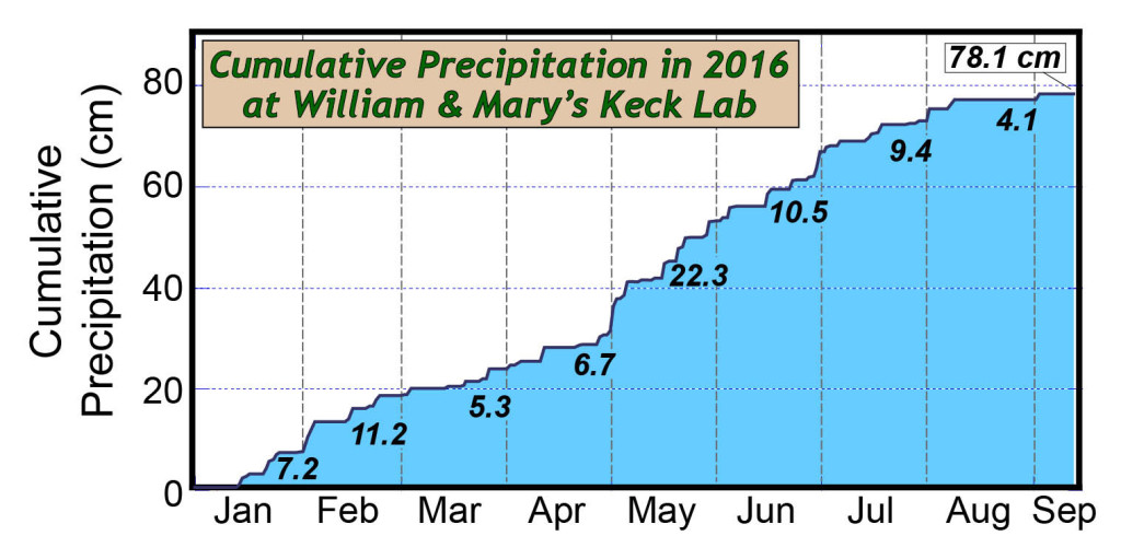
Cumulative precipitation at William & Mary’s Keck Lab weather station thus far in 2016. The black numbers in the shaded area are monthly totals in centimeters. Note the nearly flat line since mid-August – it’s been dry.
Thus far W&M’s Keck Environmental Field Laboratory’s weather station has received 78 cm (31 in.) of precipitation for 2016, and that’s pretty much normal for the first 2/3s of the year. It was a wet May and June, but the cumulative curve has gone nearly flat since mid-August because there’s been almost no rain. The Keck Lab’s weather station has been in business since 2004, and over that time the annual precipitation averages out to 111 cm (~44 in.). However, there is much variability from year to year, with a low in 2005 of 80 cm and a high in 2013 of 148 cm.
Over the course of the semester in the Weather, Climate, and Change course we discuss the variability of both weather and climate at different locations. Last Wednesday we explored precipitation in the mid-Atlantic region using a series of maps that I’d constructed.
I provided the class with three different versions of an average annual precipitation map: one was black and white with a series of isohyets (lines of equal precipitation), the second was a color-coded map with gradations between areas of differing precipitation, and the third was the same color-coded map with isohyets. All of the maps incorporate the same data, but are illustrated differently (data from the PRISM Climate Group at Oregon State University). Which map is the most functional? Which map is the most winsome?
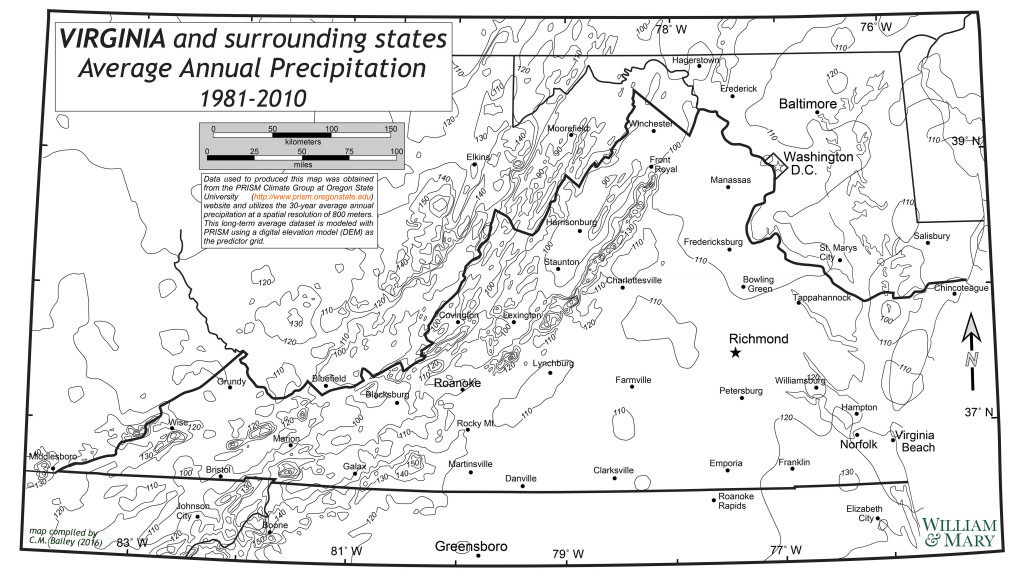
Old School- a contour map of average annual precipitation. Each contour is a line of equal average annual precipitation (isohyet). The contour interval is 10 cm. Click on the image to see a larger detailed map.
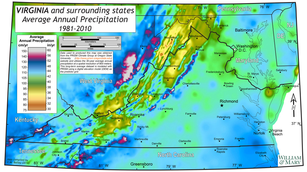
Average annual precipitation illustrated with a gradational color ramp. Click on the image to see a larger detailed map.
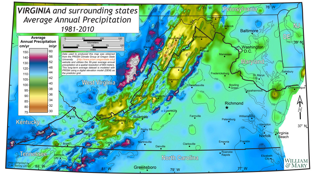
Average annual precipitation illustrated with both a gradational color ramp and isohyets. Click on the image to see a larger detailed map.
Popular opinion was strongly in favor of the third map — people liked both the eye-popping color ramp, while the isohyets grounded the map with values for average annual precipitation. Part of my exercise was to garner discussion about what makes a quality map, and how best to illustrate spatial data effectively. Personally, I’m a fan of the 2nd map, it’s less cluttered without the isohyets.
There was one additional map, a shaded relief map that’s centered on Virginia that illustrates the elevation and topography of the region. On this type of map Virginia’s physiographic regions (Coastal Plain, Piedmont, Blue Ridge Mountains, etc.) stand out.
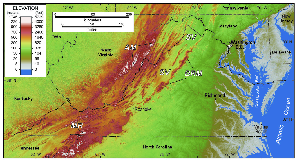
Shaded relief map of Virginia and the surrounding regions. AM- Allegheny Mountains, BRM- Blue Ridge Mountains, MR- Mt. Rogers (Virginia’s highest point), and SV- Shenandoah Valley. Click on the image to see a larger detailed map.
Is there any relationship between elevation, topography, and average annual precipitation?
Virginia’s region of lowest annual average precipitation is in the Shenandoah Valley which typically receives between 90 and 100 cm (35 – 39 in.) of precipitation annually (that’s about 20% less precipitation than Williamsburg normally receives). The Shenandoah Valley is by no means a dry region, but lower precipitation, in combination with the underlying bedrock geology, produces distinct and different soils that are more fertile than those in the eastern part of the state.
Virginia’s driest region is in a rain shadow between the Blue Ridge Mountains to the east, and the Allegheny Mountains to the west. Both ranges have peaks that rise to well over 1,000 m (3,280’). Much of Virginia’s weather comes from the west and southwest, the Allegheny Mountains force air masses to rise and deliver up their moisture. High terrain in the Alleghenies receives upwards of 150 cm (60 in) of precipitation per year. Conversely, during Nor’easters and other Atlantic weather makers, wind and rain commonly come from the east or northeast and bring ample moisture to the Blue Ridge Mountains. The high terrain that flanks the Shenandoah Valley robs the region of precipitation.
We’re hoping for rain here in Williamsburg to add some real-time weather excitement to the Weather, Climate, & Change course. The short-term forecast does not look promising, we may have to request that Clapton play Sunshine of Your Love or his cover of Blow Wind Blow.
Comments are currently closed. Comments are closed on all posts older than one year, and for those in our archive.

Is there a type of underlying bedrock geology that causes more rain in a non-mountainous area?
Why did Hurricane Hermine completely miss the Williamsburg area? What would cause a hurricane to change directions like that?
Sam-
That would be most intriguing if the rocks could make it rain more. East of the Blue Ridge Mountains there are subtle differences in precipitation patterns- the causes are up for debate.
Arjun-
Simple answer is to blame it on the Westerly Winds, they got stronger and steered Hermine eastward- leaving Williamsburg mostly dry.
See you soon,
Chuck
Chuck,
I was surprised to find out that you preferred the second map over the third one. Regardless, the blog well-sums up the aspirations of this course. I am excited to be learning in your class for the next dozen weeks!