
A Mass Movement in the Blue Ridge
By Chuck Bailey
Mid-day on Sunday (May 2nd, 2021), I crossed the Blue Ridge Mountains along U.S. Route 250. As I traveled up the mountain, just to the west of the Albemarle-Nelson county line, I noticed a modest pile of rock debris and tilted trees on the uphill side of the highway. A small mass wasting event had recently occurred—this was no surprise as the southeastern slope of the Blue Ridge near Rockfish Gap is prone to mass movement because of its geology. In 2017, we wrote a guide to the geology of the Rockfish Gap area (pdf) noting that landslides and mass wasting posed a significant hazard. As I whizzed by on Sunday, I wondered whether this rock fall/slide would grow into something significant.
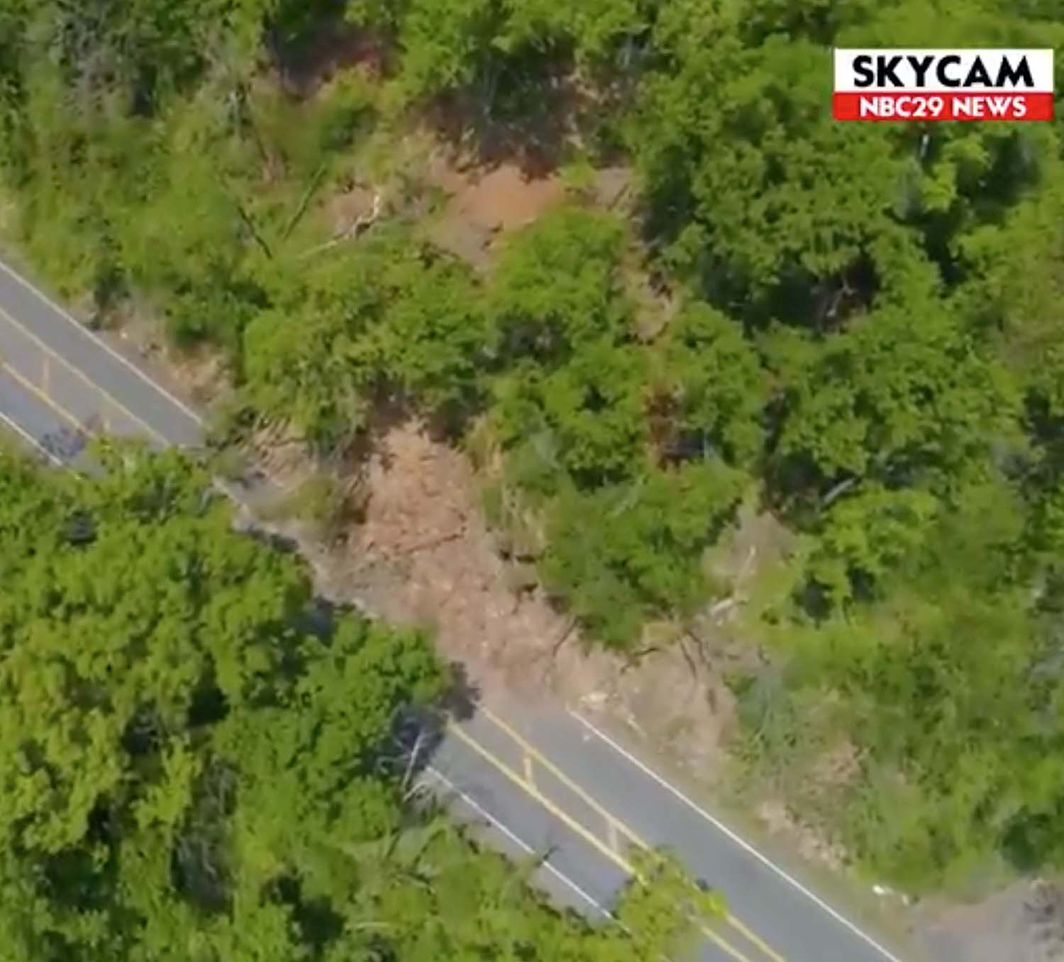
Screenshot of aerial imagery from a landslide near Rockfish Gap, Virginia. Source: NBC29
By Monday, enough rocks were moving downslope and out into Route 250 that the Virginia Department of Transportation closed Route 250. This major route across the Blue Ridge looks to be closed for the foreseeable future creating a significant traffic headache. In just one day, the size of the mass movement had significantly increased and the potential for a large catastrophic event exists.
In this post, I describe the geological particulars relating to mass wasting and landslides at this location in the Blue Ridge.
Rockfish Gap (pdf), erroneously called Afton Mountain, is the lowest point along the crest of the Blue Ridge Mountains in central Virginia. Because of its unique topographic position, Rockfish Gap has long been an important transportation route linking eastern and western Virginia. Both Interstate 64 and U.S. Route 250 transit the Blue Ridge at Rockfish Gap.
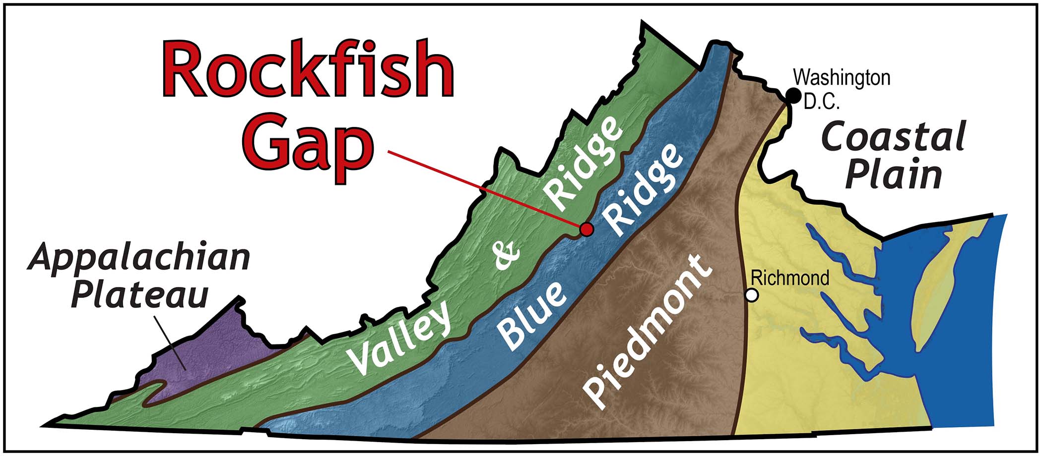
Locator map illustrating Virginia’s geological provinces and Rockfish Gap.
Along the southeastern side of the Blue Ridge these highways are cut into the underlying bedrock of the Catoctin Formation, a distinctive geological unit composed largely of meta-basalt or greenstone. 550 million years ago these were lavas that flowed across the Earth’s surface and were the forerunner of a massive continental break-up.
Two hundred million years later, eastern North America was battered by a sequence of tectonic collisions. During this orogenic mayhem the Catoctin Formation was buried to depths of 10 to 15 kilometers (6 to 10 mi.) and heated to temperatures of ~300˚ C (~600˚ F). Additionally, the collision of continental blocks crumpled and sheared these rocks. During this process, the basaltic lavas were transformed into schistose greenstone, a fine-grained foliated metamorphic rock. Foliation is the parallel arrangement of minerals within a rock that develops as rocks experience ductile deformation. Foliation is also a plane of weakness in these rocks—whack a greenstone with a hammer and it’ll typically break parallel to the foliation.
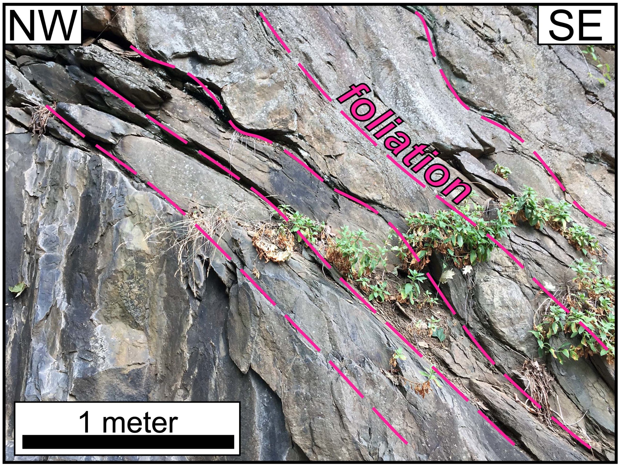
Outcrop of Catoctin greenstone with a well-developed foliation that dips at a moderate angle towards the southeast.
East of Rockfish Gap, the foliation in the Catoctin greenstone dips to the south-southeast at angles between 20 and 50 degrees. Here, the landscape slopes between 10 to 20 degrees towards the south. This presents a slope stability issue as the land surface and the rock structures are inclined in the same direction.
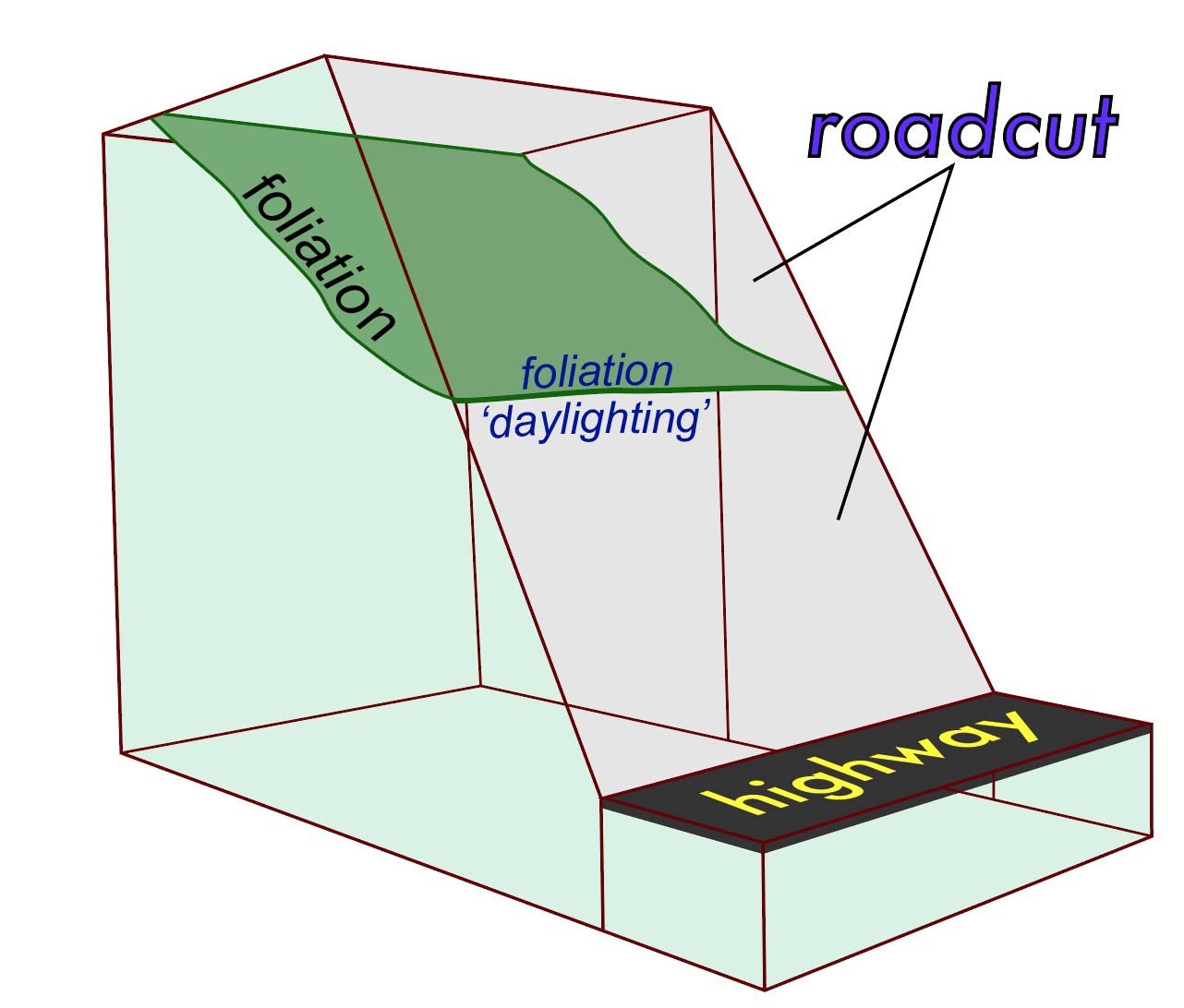
Cut-away block diagram illustrating foliation ‘daylighting’ on the surface of a highway roadcut.
To make matters worse, the roadcuts along both Route 250 and Interstate 64 are inclined more steeply than the natural land slope. Thus, the foliation typically ‘daylights’ in the highway cuts—this is bad news because it produces an unstable geometry in which mass wasting is an inevitable consequence. When the existing planes of weakness in the rock dip downward, towards the road, trouble is likely not far off.
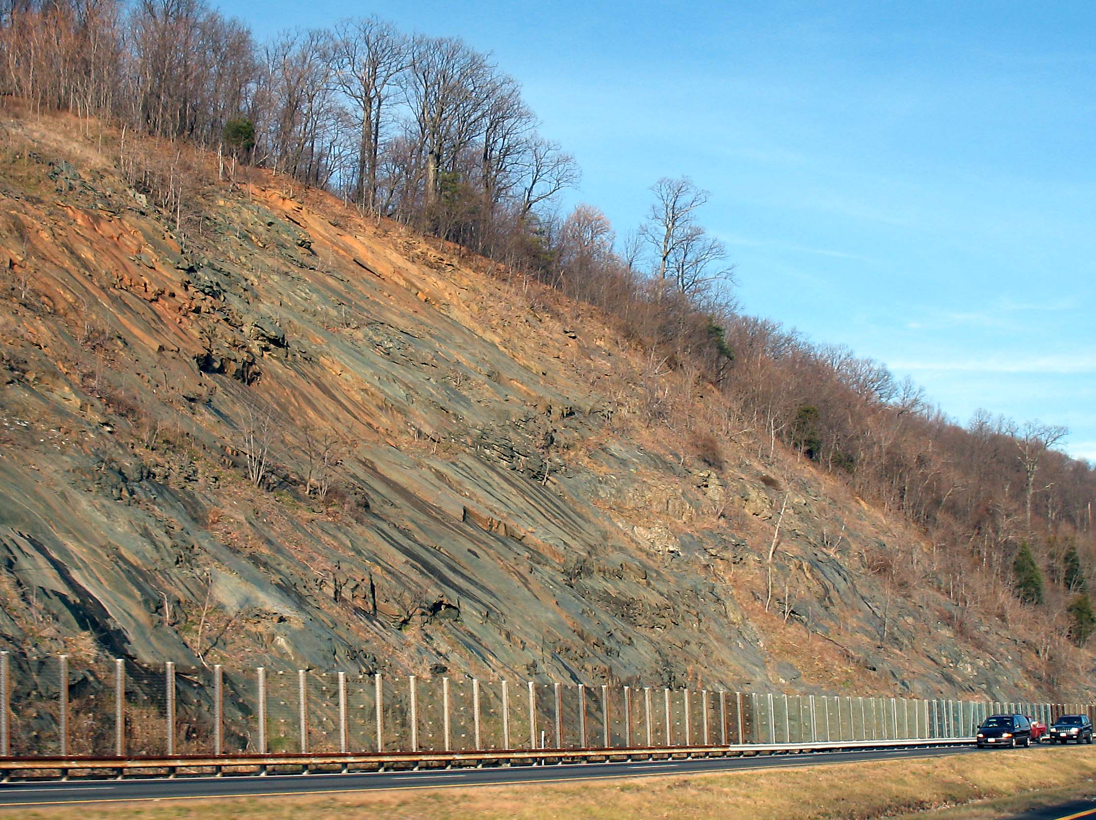
Highway roadcut along Interstate 64. Note: the foliation dips moderately towards the road, a situation that makes mass wasting likely.
As rain percolates into the subsurface, it preferentially flows parallel to the foliation and through fractures in the greenstone. In the winter and early spring, as the water freezes and thaws, it may pry the rock apart causing slabs to move down slope towards the highway. Loose rock and the overlying soil may creep downward at velocities of a few centimeters (1-4 in.) per day, or rush downward at rates of >10 kilometers per hour (>6 mph).
The structural geometry of the underlying bedrock in this part of the Blue Ridge presented a huge challenge for both railroad and highway engineers. In the 1850s, Claudius Crozet struggled to build the first railroad across and under the Blue Ridge (pdf) here. More than a century later, highway engineers constructing Interstate 64 faced similar difficulties. Landslides were common during construction and clearly, they continue well into the 21st century.
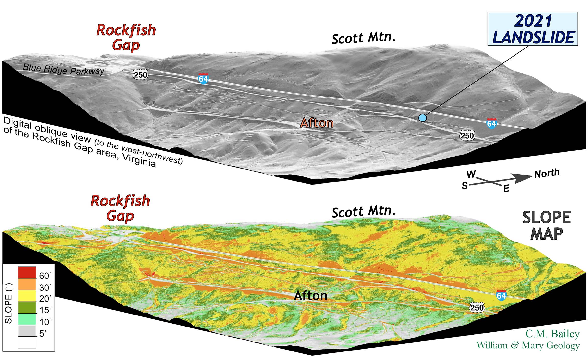
Figure 6. A digital oblique view of the Rockfish Gap area, Virginia. Image created from LiDAR elevation data. The lower image is colored based on the land slope. Slopes in excess of 20˚ are steep, note that the orange and red colors (denoting slopes >30˚) are typically associated with highway cuts along U.S. Route 250 and Interstate 64. Click on the image for a more detailed view of the topography.
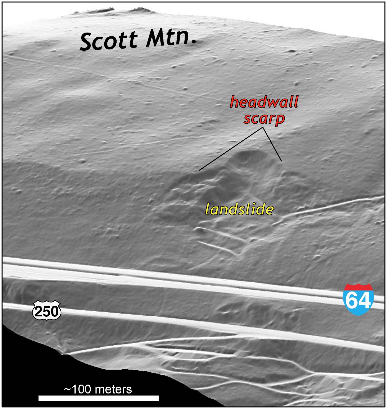
The 2021 slide is (for the moment) relatively small and appears to be a reactivated landslide. That is, mass movement has occurred previously at this site as evidenced by the headwall scarps evident on the LiDAR-based map. It’s a ridiculously steep site that is tightly hemmed in with Route 250 below and Interstate 64 above.
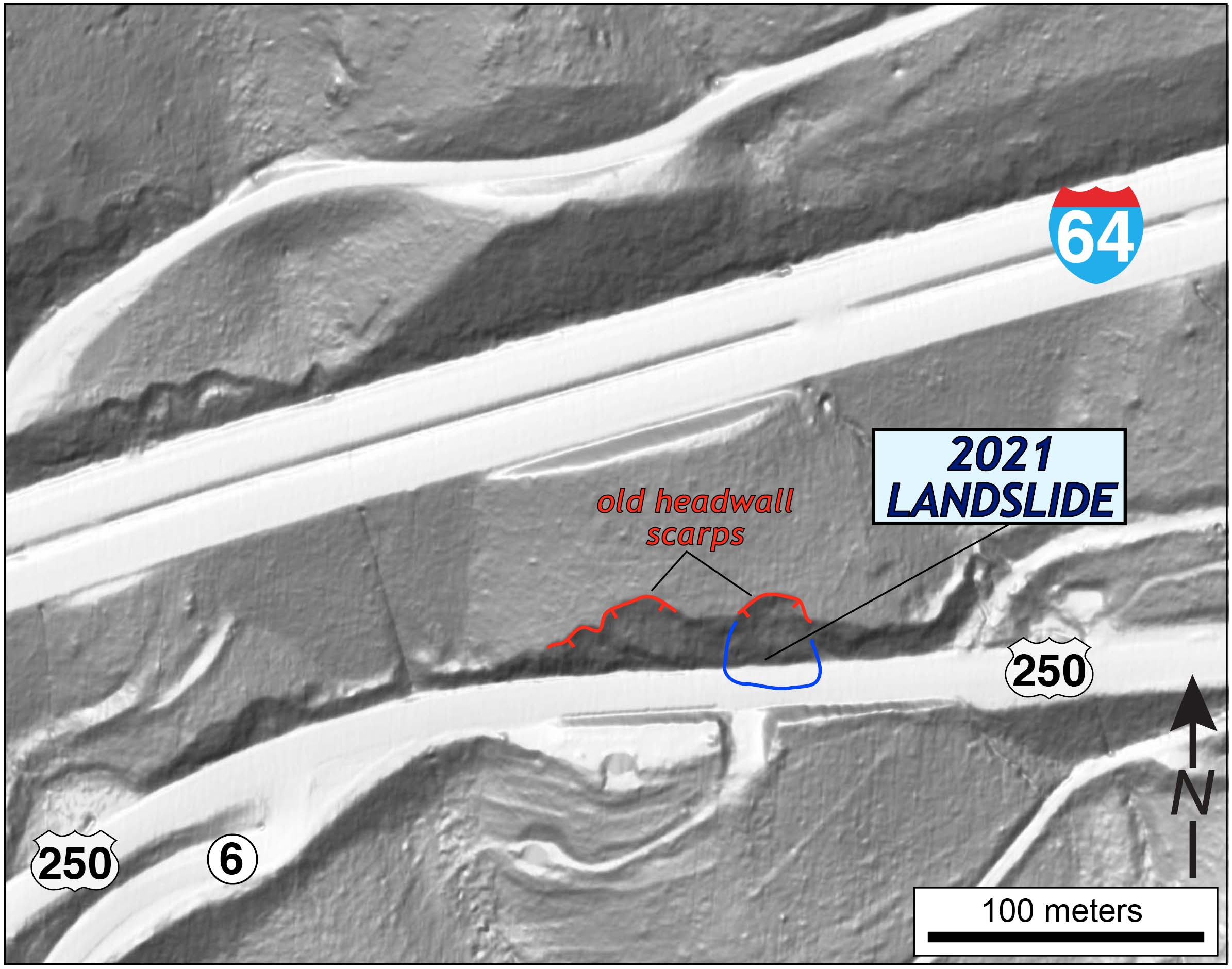
Figure 7. Shaded relief map of the 2021 landslide along U.S. Route 250 near Rockfish Gap, Virginia.
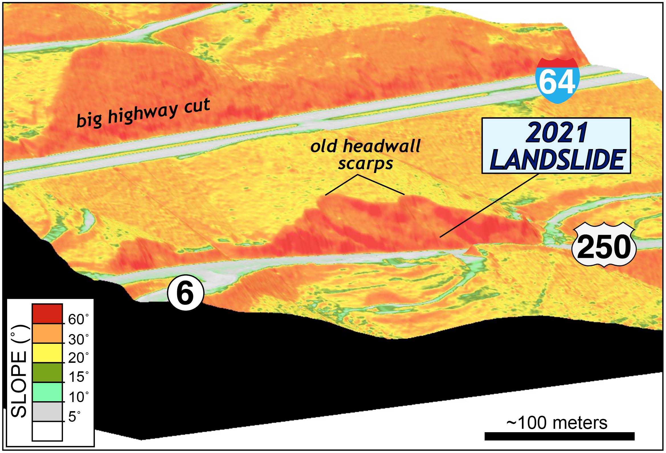
Oblique digital view (to the northeast) of the terrain at the 2021 landslide site, the colors are based on the land slope. The steepest terrain in this image are primarily highway cuts into bedrock.
Anne Witt, a landslide specialist at the Virginia Division of Geology and Mineral Resources, inspected the site on Tuesday and discovered a large tension crack at the surface to the east of the original headwall scarp. The photo below illustrates this impressive tension crack across which a mass of rock, soil, and vegetation moved 30 to 50 centimeters downslope. She also noted that the rock is well-foliated and dips towards the road. To quote Anne “it is a perfect place for rock slope instability”! The foliation is likely the sliding surface while the slide itself probably detached across a perpendicular joint set near the headwall.
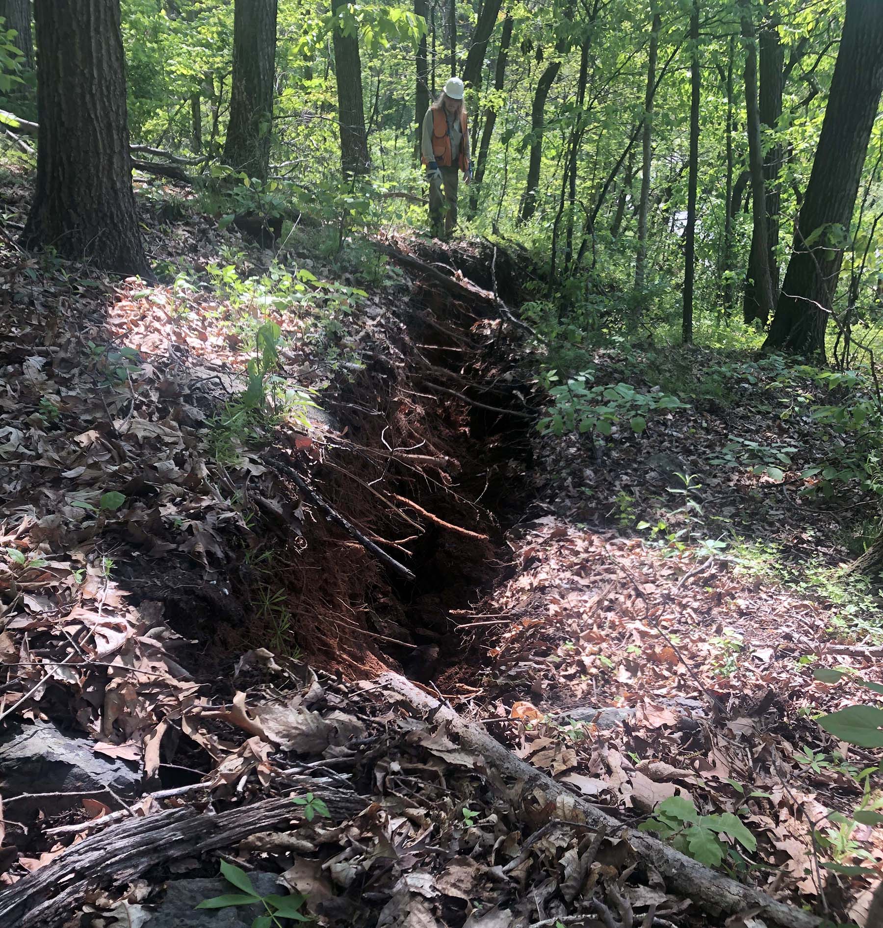
A massive tension crack developed at the surface. Material on the right side of the image has been translated down slope towards U.S. Route 250. Photo courtesy of Anne Witt, Virginia Division of Geology and Mineral Resources.
Here’s the good news – Anne noted that there are no scarps or cracks uphill from the main headwall scarp, indicating that (as of Tuesday) the mass movement is not moving upslope and, in the process, ever closer to Interstate 64. VDOT will commence excavations to remediate this landslide yet that brings uncertainty, as undercutting the slope from below could trigger more movement.
This 2021 event raises questions relating to landslide hazards near Rockfish Gap:
- How large can these landslides become? Could these mass movements become so large that they’d cause catastrophic damage? Landslides that don’t just drop rocks onto the highway, but rather take out an entire swath of Interstate 64 or Route 250. Numerous homes are cut into and built on the southeastern slope of the Blue Ridge near Route 250. Are these homes in harm’s way?
- How fast do these mass movement events occur? Do they creep slowly down slope, causing damage to roads and structures but plod along slowly enough so as to not pose a risk to humans? Or can these events transition from the slow and creepy into major landslides that charge quickly down the mountainside leveling everything in its path?
- What’s the trigger for mass wasting in the Blue Ridge? Heavy rains commonly lead to mass movement in mountainous terrain. Precipitation not only loads the slope with more mass, but also lowers the shear strength of soils/regolith. But there are other ways to trigger mass wasting – seismic shaking can jar a whole mountainside loose while pumping fluids in or out of the ground can change stress conditions. What triggered the 2021 movement?
With the LiDAR imagery it is a straightforward process to identity old landslides in the area. For the most part these are small slides of limited area, but nearly all of the slides appear to be related to slopes that have been steepened by human activities– primarily road or railroad cuts and at excavated building sites.
Shaded relief image of historic landslide above Interstate 64 near Rockfish Gap. Oblique view (to north-northwest). Click on the image for a more detailed view.
In summary, the local geology and topography of the Blue Ridge near Rockfish Gap are well-suited for mass wasting. Add to that the numerous over-steepened slopes associated highway cuts and construction sites and we’ve got a perfect place for rock slope instability. Mass movement events will continue to occur on the Blue Ridge, and the risk of a significant slide is ever present.

Comments are currently closed. Comments are closed on all posts older than one year, and for those in our archive.
Every engineer should read this beautifully written article. There is often a disconnect between the disciplines of geologists and engineers. Geotech firms are great but there is no substitute for this understanding of bedrock geology. The two disciplines can be extremely complementary when connected. We desperately need both engineers and geologists working together to accomplish safe design.
Well stated
Great explanation Chuck! I drove up to Wintergreen on Monday and saw the slide. I immediately thought of you!
Chuck, as soon as I saw the article I thought you might have a hand in it!
One doesn’t need to be an engineer to find this fascinating!
Your note about how VDOT will work on “remediating” the slide by removing the toe is once again horrifying. My MS thesis was on the “Narrows Slide” along US 460 east of the town of Narrows and just above the Celenese Fibers plant. Since US460 was built across the toe of the slide, VDOT “maintenance” and actual mining of the toe for materials to fill in other areas has been the single biggest trigger of subsequent slides. Those who do not learn the lessons of the past are condemned to repeat the mistakes.
I am not a smart person so to speak, but I was wondering if the opening of the tunnel in this area had anything to do with this shifting?
Mr. Bailey, Excellent use of lidar to show the terrain and explain what is happening. It is a fascinating technology.
I have to wonder about the long-term stability of 64 in this area, if landslides are occurring so close to it.
Fascinating. Thanks.
It sounds like the employees of VDOT were not the best engineers when designing the path of 64 and took away too much of the mountain which now might come back to bite them, and those of us to use it.
Very interesting…those who have been around for a while may remember that 64 was planned to go further south— ear Lynchburg I believe. Politics influenced the plan and 64 took a Charlottesville route. We need to add politicians to Geologist and Engineers when it comes to working together! Great article—thank you!
What has occurred since confirms the outcome[s] worst feared by Dr.Byron Cooper, Geologist, Head of Department of Geology at VTECH as shared with me in 1969. Dr. Cooper and others strongly advised, fought against the existing route for I-64 recognizing the extreme risks of what occurred recently.
Don Faulkner
Outstanding job on this Chuck! I have several friends that were wondering what caused the route 250 slide and also the reason for the instability above I-64 many years ago that caused VDOT to remove a lot of ‘earth’ from the side of the mountain. This explains everything perfectly and in addition to my thanks, I’ll thank you for them, as well!