
Where & When?
Here is the opening question from the last problem set in my Earth’s Environmental Systems course (GEOL 110).
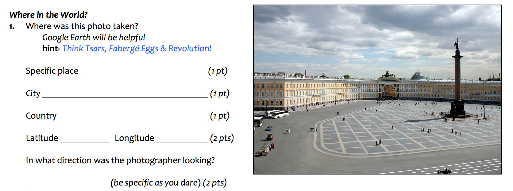
I thought my clues were amply generous. The photograph is of Palace Square in St. Petersburg, Russia. Google Earth is a great tool for checking out this scene and determining the latitude and longitude (59.9˚ N, 30.3˚ E). Inspecting the scene in Google Earth makes it clear that the photographer was looking to the South across Palace Square from a window in the Hermitage Museum.
That was the prelude. The 2nd part of the question asks.
Mike Blum, W&M Academic Technology Specialist Extraordinaire, took the photograph. His wife, Professor of Modern Languages Bella Ginzbursky-Blum, often directs William & Mary’s summer study program in St. Petersburg. I first saw the photo framed on the wall at their house and was captivated by the scene. When I asked to use the photo I told them NOT to tell me the date and time at which the picture was taken—if I’m going to ask W&M students to figure that out I’d better be able to do the same.
So just how do we figure out the date and time when the photograph was taken? The key lies in the shadow cast by the massive Alexander’s Column at the center of the square. Alexander’s Column is a large monument erected in the early 1830’s to celebrate Russia’s victory over Napoleon’s armies. It stands 47.5 meters tall and is reputably the world’s tallest column made from a monolithic block of rock (granite, in this case).
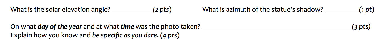
By making a triangle between the column and the shadow we can determine the solar elevation angle (Ψ) by either measuring it directly on the photo with a protractor (my students say that’s old school because they last used protractors in elementary school) or by using a dash of trigonometry. The solar elevation angle at the moment the photo was taken is 47˚.
The solar declination (δs) follows an annual path that crosses the equator at the equinoxes and reaches 23.45˚ N (Tropic of Cancer) on June 20th/21st and 23.45˚ S (Tropic of Capricorn) on December 21st/22nd. This path is graphically illustrated by the analemma, that strange figure-8 shape lurking in the Pacific Ocean on many globes.

Analemma illustrating the solar declination throughout the year. Note subsolar point at or north of 17˚ N between May 9th and August 4th. Globe courtesy of Sofia Mendez.
Recall that St. Petersburg is located at 59.9˚ N latitude and we measured a solar elevation angle (Ψ) of 47˚ at Alexander’s Column. For the sun to reach a solar elevation angle of 47˚ in St. Petersburg the solar declination must be at 17˚ N or further north (Ψ = 90˚ – [Latitude of St. Petersburg – δs]), reading the analemma reveals that the solar declination is ≥17˚ N from May 9th until August 4th. At any other time of the year the sun never gets high enough in the sky to reach a solar elevation angle of 47˚ in St. Petersburg. Ok, we’ve narrowed the range of dates to just under three months, but we can do better.
The azimuth of the column’s shadow is pointing to the northeast (an azimuth of 41˚, actually), which means the sun is located to the southwest (an azimuth of 221˚ which is 180˚ from the shadow). Local noon occurs when the sun passes due south of a particular location (for mid-latitude locations in the northern hemisphere) and the sun tracks to the southwest in the afternoon—clearly this photo was taken in the mid-afternoon. The sun reaches its zenith at local noon and then the solar elevation angle gets progressively lower throughout the afternoon. Put another way, if the solar elevation angle in the afternoon is 47˚, it’d be even higher at local noon.

Annotated image of Alexander’s Column in Palace Square denoting the solar elevation angle (Ψ) and shadow azimuth (α).
There is an explicit relationship between the solar elevation angle (Ψ) and the azimuth angle of the sun (α) that can be determined for any latitude and time. It’s given by two cumbersome trigonometric formulas (not shown), but if one’s latitude and the solar declination (date) are known we can calculate when the sun rises and sets and its position throughout the day.
For our picture of Palace Square, we know the solar elevation angle (Ψ) at that moment = 47˚ and the azimuth angle of the sun (α) = 221˚. There are only two days of the year that yield that combination of elevation angle and azimuth—June 3rd or July 11th at 14:54 (2:54 p.m.)*. I suspect it’s the earlier date—June 3rd. Look closely at the people in square: they are bundled up, suggesting it is a cool day in St. Petersburg, I’d expect cool weather in early June more so than July.
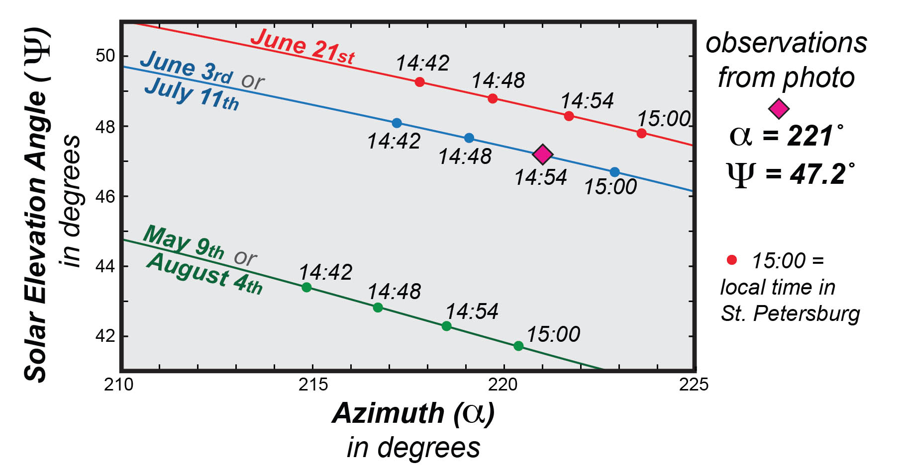
Solar elevation angle versus azimuth plot for St. Petersburg, Russia. Elevation and azimuth best match June 3rd or July 11th at 14:54 local time.
I forwarded my answer to Mike and Bella: Mike responded “Not bad. June 3, 2004 at 2:49 p.m.”. I was off by 5 minutes, but this is where the equation of time and the analemma come to the rescue.
The north-south component of the analemma illustrates the solar declination throughout the year, but the east-west component illustrates the equation of time and whether the sun is ahead or behind clock time. Because the Earth’s orbital path around the sun is elliptical, and the Earth’s rotational axis is tilted relative to the ecliptic plane, there is a difference between mean solar time and apparent solar time that varies regularly throughout the year. On June 3rd the sun is 3 minutes ahead of clock time—so my final answer is 14:51.
Did I only give credit for June 3rd at 14:51 local time? No, full credit answers went to anybody that put the date between June 1st and July 15th and called it mid-afternoon. Collectively, the class did fine. As I’ve mentioned in earlier posts, I want students to be able to think spatially: questions like this are meant to get spatial thinking skills into high gear.
Why pose a question like this? Who, especially in a first-level non-majors course, is likely to employ this type of analysis (photogrammetry) somewhere down the road? Very few I expect, although photogrammetric analysis is regularly employed by intelligence agencies (how do you think the Russian missile sites in Cuba were sussed out back in 1962?) and has been utilized to offer insight on controversies such as who first reached the North Pole. But more importantly, I want William & Mary students to use their own observations to understand the world. These types of questions might appear to come from ‘left-field’, but neatly demonstrate how much can be discovered about the Earth’s environmental systems from close inspection of everyday scenes.
*St. Petersburg is on Moscow time.


Comments are currently closed. Comments are closed on all posts older than one year, and for those in our archive.
The dating is the only part that tripped me up in this problem. It never occurred to me that the azimuth could be correlated to a constant date throughout the year.