
A Structural Geology Trifecta
Saturday found the 2017 W&M Geological Field Methods course in the field. This year’s class is composed of 16 junior and senior geology majors, and our field projects have taken us from the College Woods to the Fall Zone to the Blue Ridge Mountains.
One of our Blue Ridge projects is focused on mapping the geology of Byrom Park in northwestern Albemarle County (~25 km northwest of Charlottesville). This 600-acre park is draped across steep terrain on the eastern side of the Blue Ridge Mountains.

A shaded relief oblique view of the Blue Ridge Mountains in northwestern Albemarle County, Virginia from a 1-meter digital elevation model (DEM). The view is to the north with an oblique viewing angle of 25˚. The width of the image (at the bottom) is ~4 km (2.5 mi.). The terrain is not vertical exaggerated. The terrain is quite steep. Note the stair-stepped landscape on the upper parts of Big Flat and Little Flat mountains, the ‘steps’ are gently dipping layers of metabasalt from the Catoctin Formation, that are likely individual lava flows. Bedrock outcrops, debris flow chutes, and fan deposits are evident in the LIDAR data. Click on the image for a bigger and more detailed view.
Eleven years ago, with a team of W&M undergraduates we mapped the geology of this region as part of a U.S. Geological Survey EDMAP grant, but we had a large area to cover and completed only two reconnaissance traverses across the park. The results of that study were published in the geologic map of the Shenandoah National Park region in 2009. Last year, new and detailed topographic data (LIDAR- Light Detection and Ranging) with sub-meter accuracy, became available for this region. These data are amazing in their level of detail – as many landscape features such as bedrock outcrops, debris flow chutes, and old logging trails are evident. With a new high resolution base map, I thought it’d be an interesting exercise to see if we could produce a better geologic map.
Part of the Field Methods class followed me to the far end of the park to revisit a curious outcrop I’d first seen in June of 2006. Our journey was mostly up, as we climbed >300 meters (1,000’) from the parking area. The reward was a small set of cliffs jutting out of a steep southwest-facing slope. These cliffs expose a remarkable structural geology trifecta as bedding, cross bedding, and foliation are all evident at the same exposure.
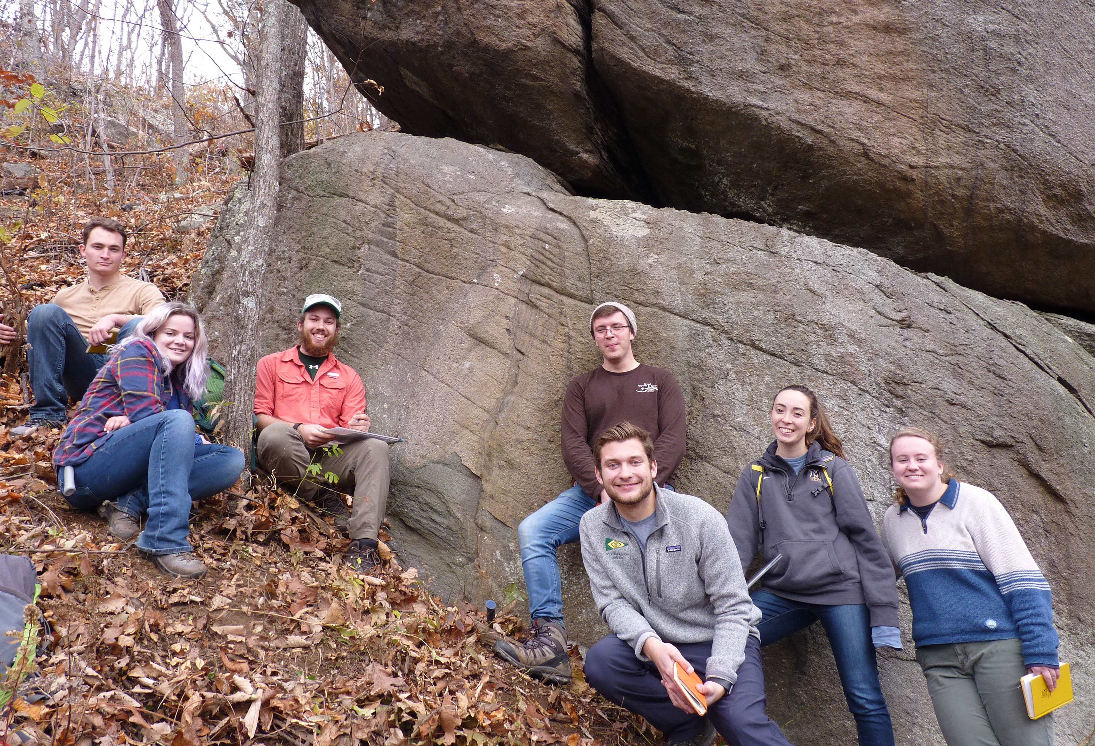
The Up-and-Away team, part of the 2017 Geological Field Methods course, on a steep Blue Ridge slope in front of a spectacular outcrop of meta-conglomerate and meta-arkose. These rocks are part of the Ediacaran Swift Run Formation.
The original layers (bedding) of gravel and sand are steeply inclined. Some of the coarse-sand layers include stratification that’s at an angle to the bedding; this is cross bedding and forms as sediment was transported over and down the leeside of ripples and bars, most likely in an energetic stream channel. Foliation cuts across the bedding and cross bedding, it forms the diagonal rills on the cliff face. Foliation is a planar feature that forms as rocks are squeezed and sheared; original sand grains and pebbles are stretched parallel to the foliation, while new minerals that form during deformation and metamorphism become aligned. Rocks tend to split parallel to foliation (also known as rock cleavage) because of the preferential alignment of minerals.
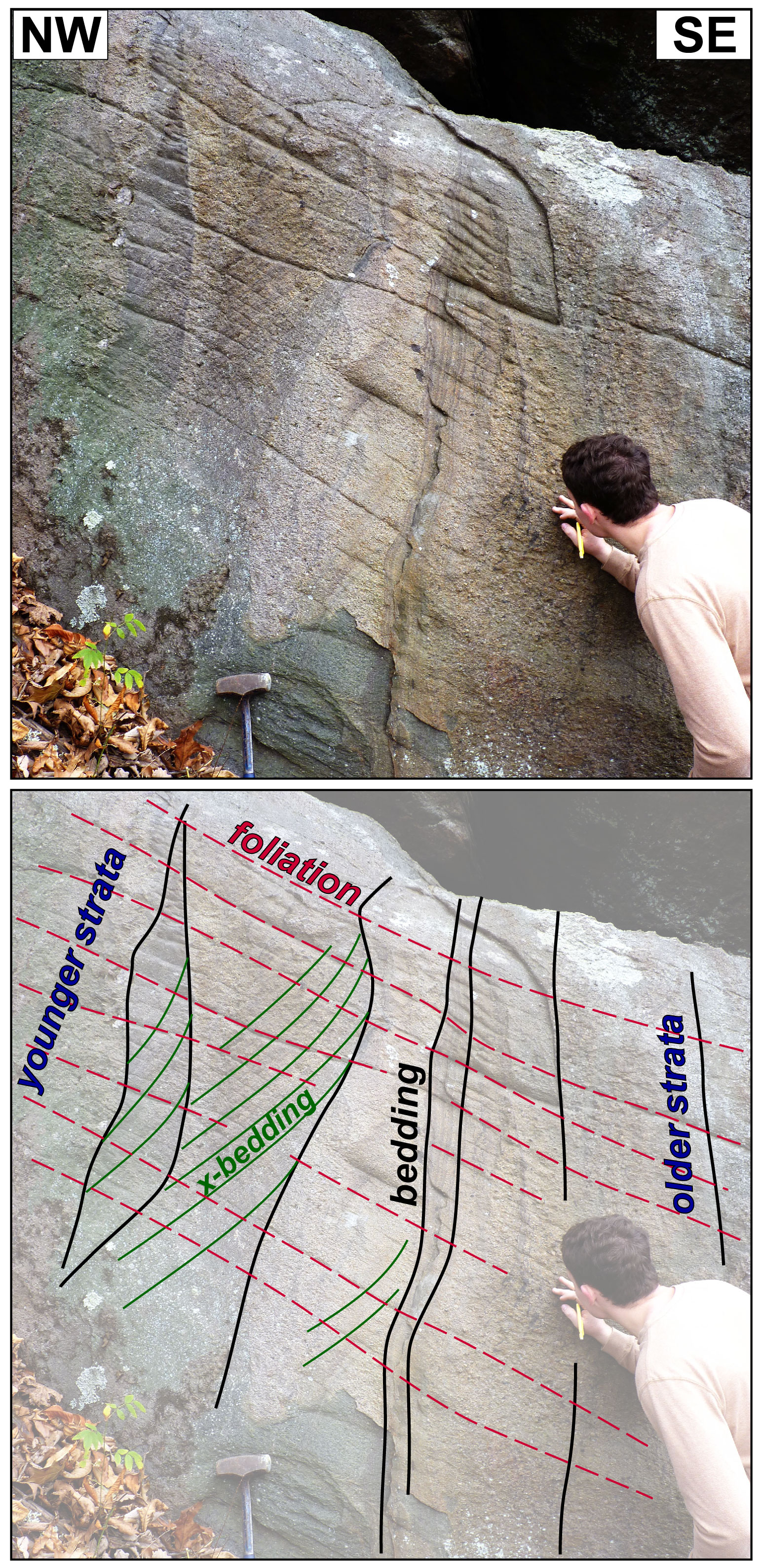
Koltyn Caricofe (W&M Geology, Class of 2019) takes a close look at a structural geology trifecta of bedding, cross bedding, and foliation in the same outcrop.
Let’s take the outcrop tracing and rotate it such that the bedding layers are approximately horizontal; this would be the geometry in which the sediment was originally deposited. In this orientation it’s easier to determine the relative timing of the strata, and the cross beds look like those in modern sediments. The Swift Run Formation was deposited during the Ediacaran period ~550 to 570 million years ago, and sits with profound unconformity on 1 billion-year old granitic rocks of the basement complex.
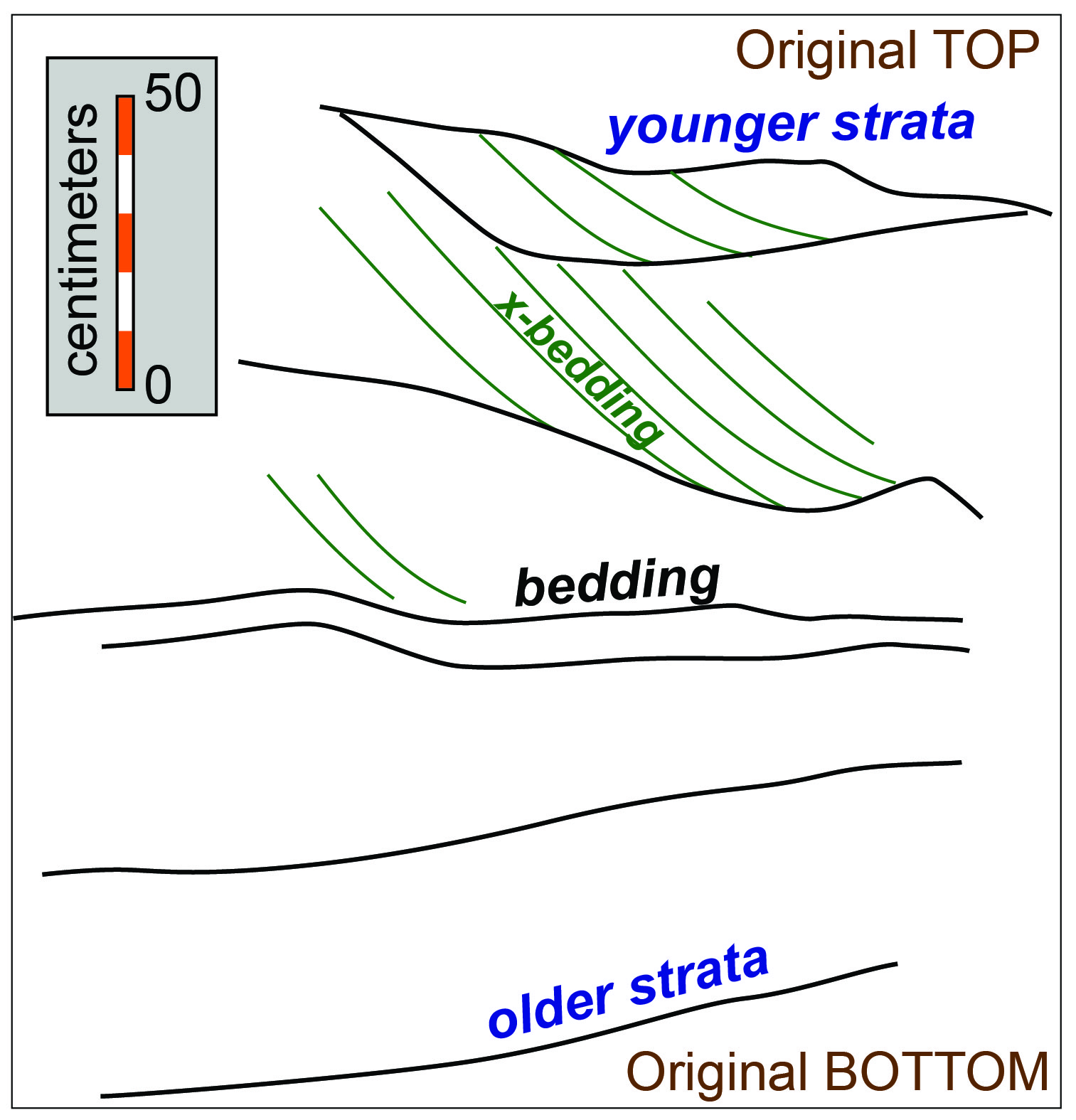
A pre-tilting and pre-foliation view of the Swift Run Formation strata. This figure was constructed simply by rotating the outcrop tracing such that bedding was restored to an approximately horizontal attitude.
Questions I had included: how long did it take for these strata to accumulate (a month, a year, decades, or millions of years?) and when were these rocks deformed? Clearly great forces were at work to tilt these strata such that they now stand on end. These are worthy questions, but questions that can’t be answered on the outcrop.
I’ll finish this post with one more picture, a colorful slope map of the Byrom Park area. I created this map from the 1-meter LIDAR data, and more landscape detail jumps out. The slope map also reveals just how steep much of the Blue Ridge can be – slopes >30˚ are quite steep. For the field geologist looking to discover bedrock outcrops, head towards the warm colors. For the field geologist looking to study debris flow fans, head towards the more gently sloping terrain (in gray) that extends downward from steep valleys.
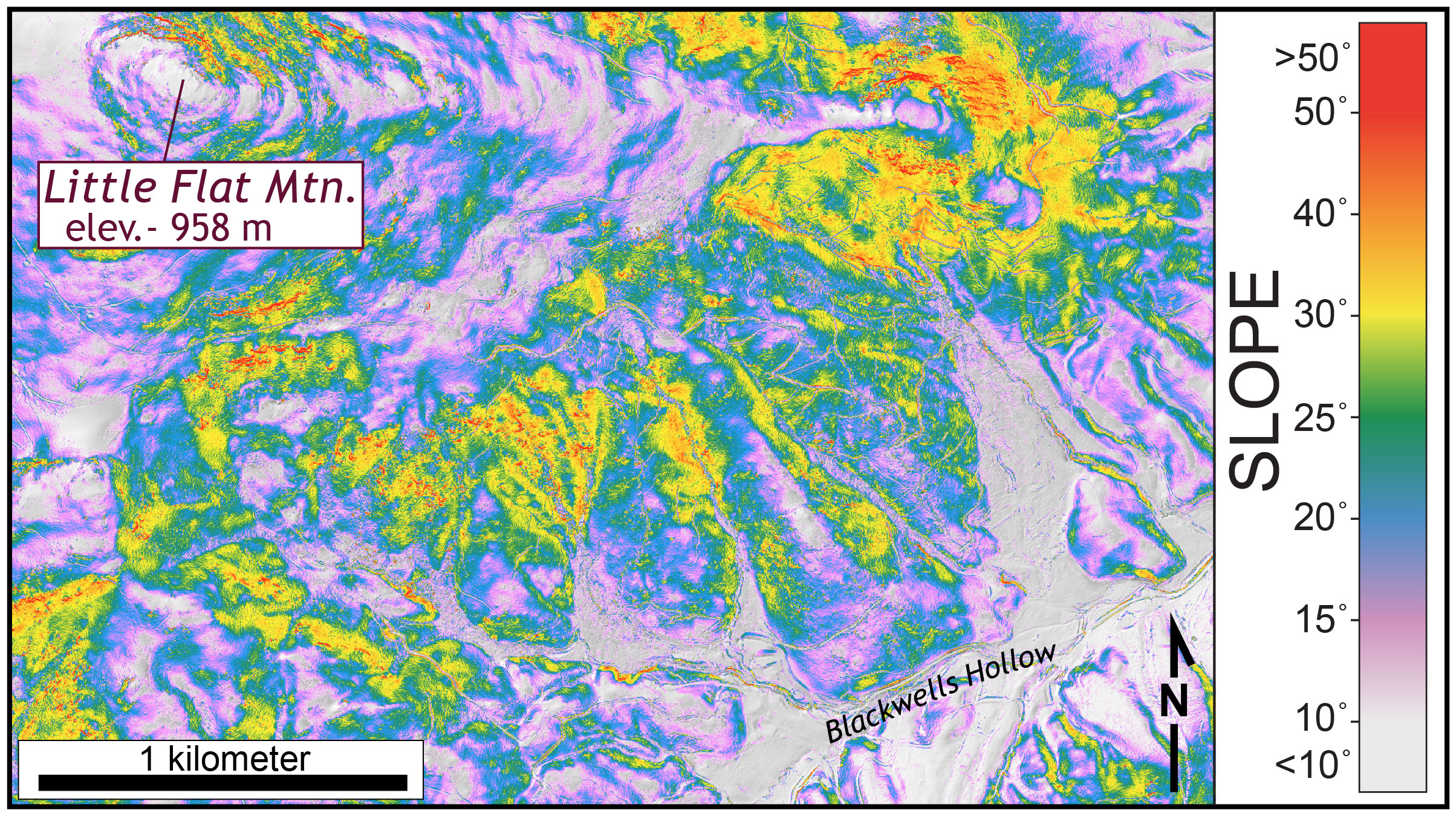
Slope map of the Byrom Park area (derived from the 1-meter LIDAR data). The areas in gray are relatively flat. The areas in yellow, orange, and red are steep with slopes >30˚, slopes of this steepness are a challenge to both walk up and to come down! Many of the red areas (>50˚ slopes) are bedrock cliffs.
The Field Methods class will finish their Blue Ridge project (and a few others) in the coming weeks. Each of these projects creates new geological knowledge, as they are not canned activities that I trot out every time I teach this course. Our findings often lay the foundation for more detailed senior research projects and research presentations at geologic conferences. In a few weeks, I’ll post a summary of the 2017 W&M Geological Field Methods research accomplishments.


Comments are currently closed. Comments are closed on all posts older than one year, and for those in our archive.
The various geological structures presented in the Swift Run Outcrop at Byrom Park illustrate the complexity of the Blue Ridge Anticlinorium. Since the Ediacaran period, the sediments entombed in the Swift Run Formation have been deposited, metamorphosed, and exposed — presenting a valuable opportunity for us, to climb up a mountain and stand in awe at its sublimity.