
Aground on the Hampton Bar with the Sea Making a Fair Breach
200 years ago this month, in early April 1823, a ship foundered and sunk onto a shallow sand bar in Hampton Roads, Virginia. On April 5th its loss was reported in the Baltimore Patriot & Mercantile Advertizer which noted that a schooner “laden with stone” went aground on the Hampton Bar “with the sea making a fair breach.” That stone cargo was bound for Fort Monroe at Old Point Comfort and remained submerged until 2020 when exploratory dredging for the Hampton Roads Bridge Tunnel Expansion discovered the wreck mired in sediment west of the existing North Island/Portal.
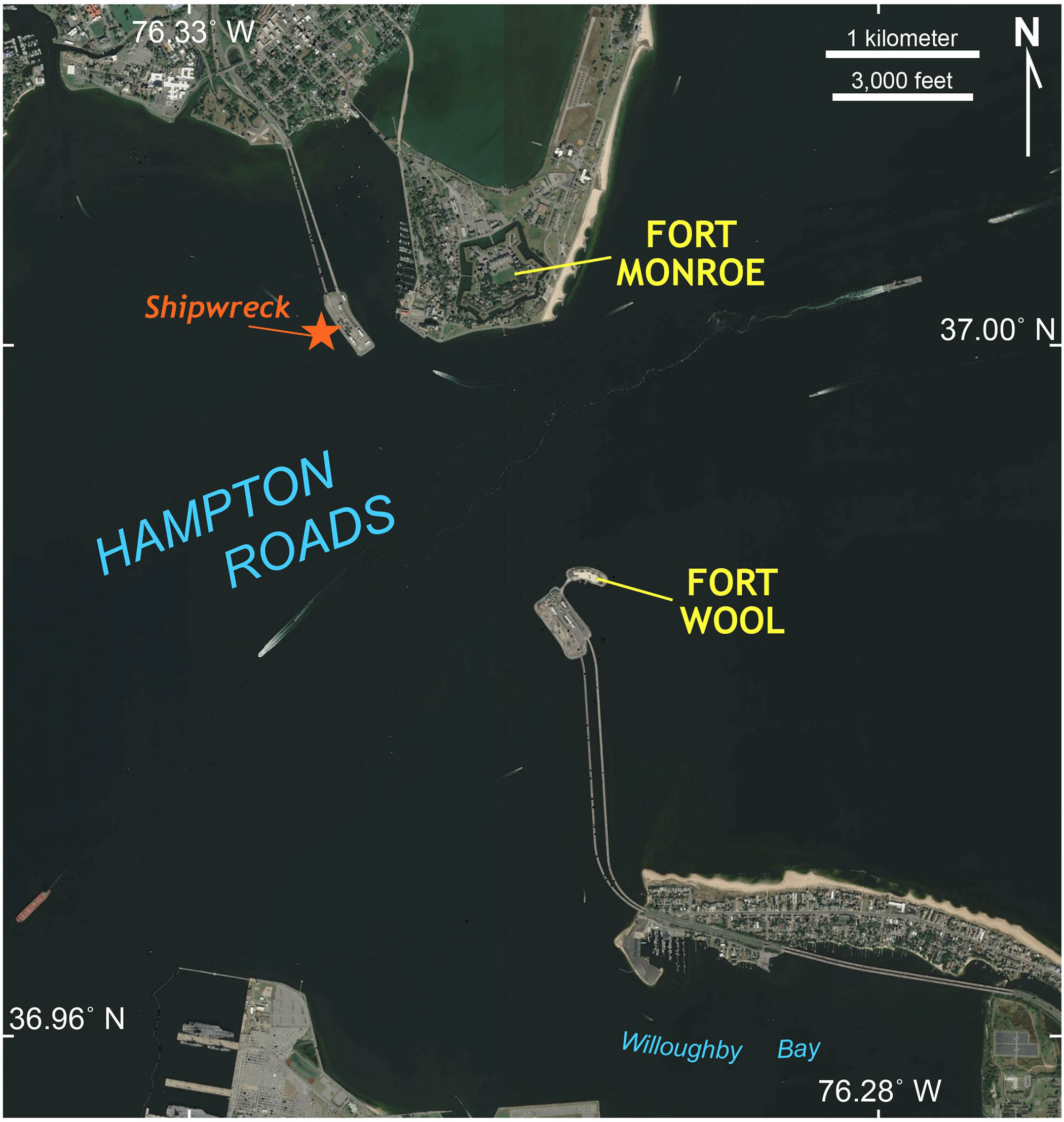
Google Earth imagery of Hampton Roads illustrating the location of the 19th century shipwreck, Fort Monroe, and Fort Wool.
The materials recovered from this shipwreck include timber framing, a section of the wooden keel including its forefoot knee and futtock, as well as a small assortment of artifacts. Plus, there was a multi-ton haul of quarried stone blocks.
From where did this stone come?
The stone did not come from Old Point Comfort or anywhere in eastern Virginia, as the Mid-Atlantic Coastal Plain is underlain by all manner of unconsolidated sediment (sand, silt, shelly marl, and mud), but no rock. In 2021, William & Mary’s Center for Archaeological Research reached out to me and I joined their research team to determine the provenance of both the recovered stone and the ship itself.
Approximately 80 stones from the wreck are stored at a Virginia Department of Transportation facility in Chesapeake. The largest blocks are ~50 x 60 x 120 cm (0.4 m3), and most blocks are rectangular to sub-rectangular with 2 or 4 parallel flat surfaces. Tool marks from quarrying are common. Interestingly, some of the block surfaces are encrusted with oysters and calcareous worms! This is cool, but not surprising, given that these rocks lay submerged in the subtidal zone of Hampton Roads for nearly two centuries providing a hard substrate for these critters to flourish.
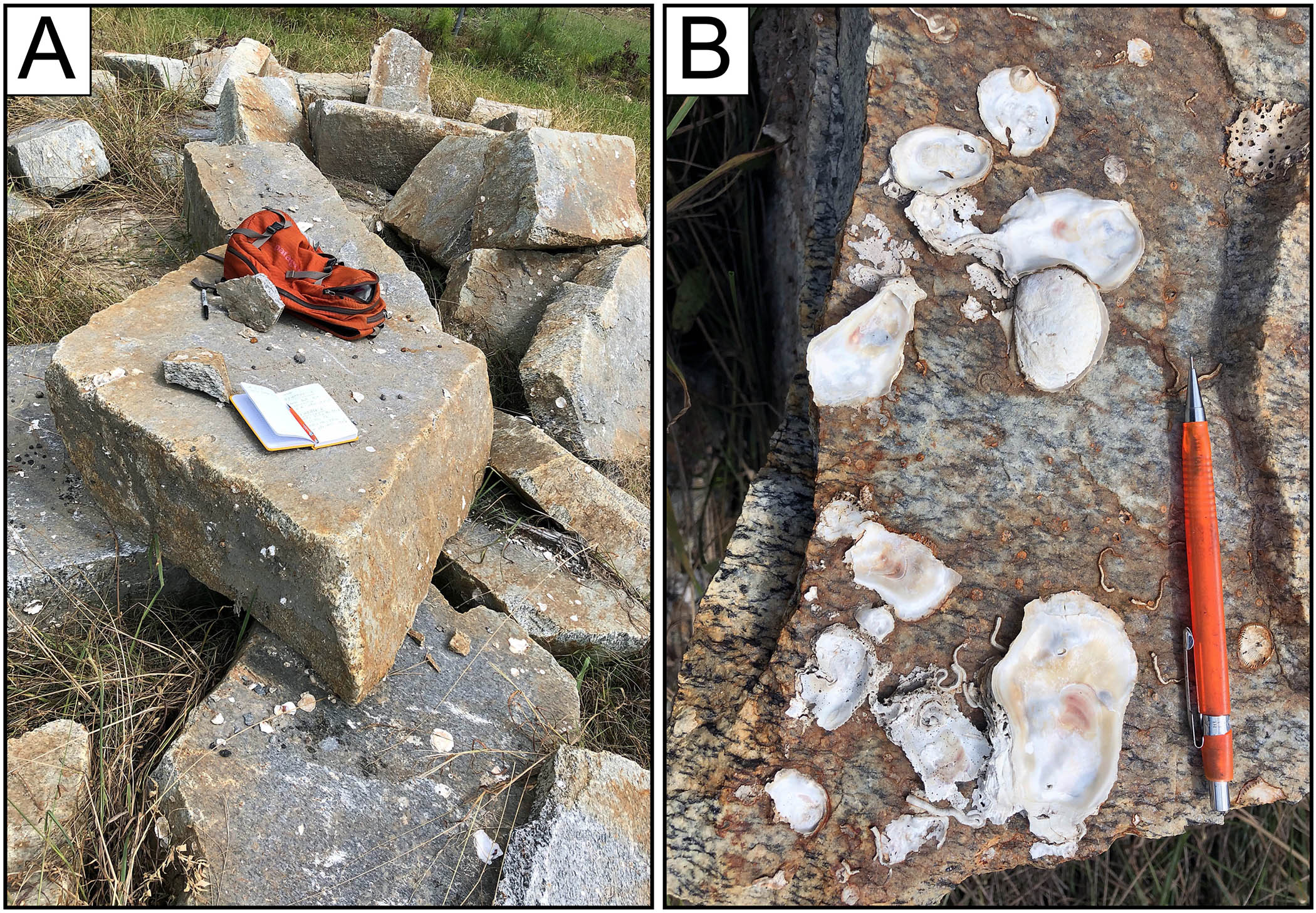
Images from the recovered stone blocks. A. Some of the granitic gneiss blocks, note the planar faces on many blocks, these are natural joints (cracks in the rock), the block with the book and backpack is 1.2 m in long dimension and about 0.4 m thick. B. Oysters and calcareous worms on the block surface – tangible evidence that the stones were submerged.
The rock is a medium- to coarse-grained granitic gneiss with a moderate to well-developed foliation and some distinctive shear bands. The primary minerals are plagioclase feldspar, quartz, and biotite with accessory minerals such as K-feldspar, hornblende, muscovite, epidote, titanite, apatite, and Fe-oxides. There are a few quartz veins, and screens of a fine-grained epidote-rich gneiss enclosed by the granitic gneiss.
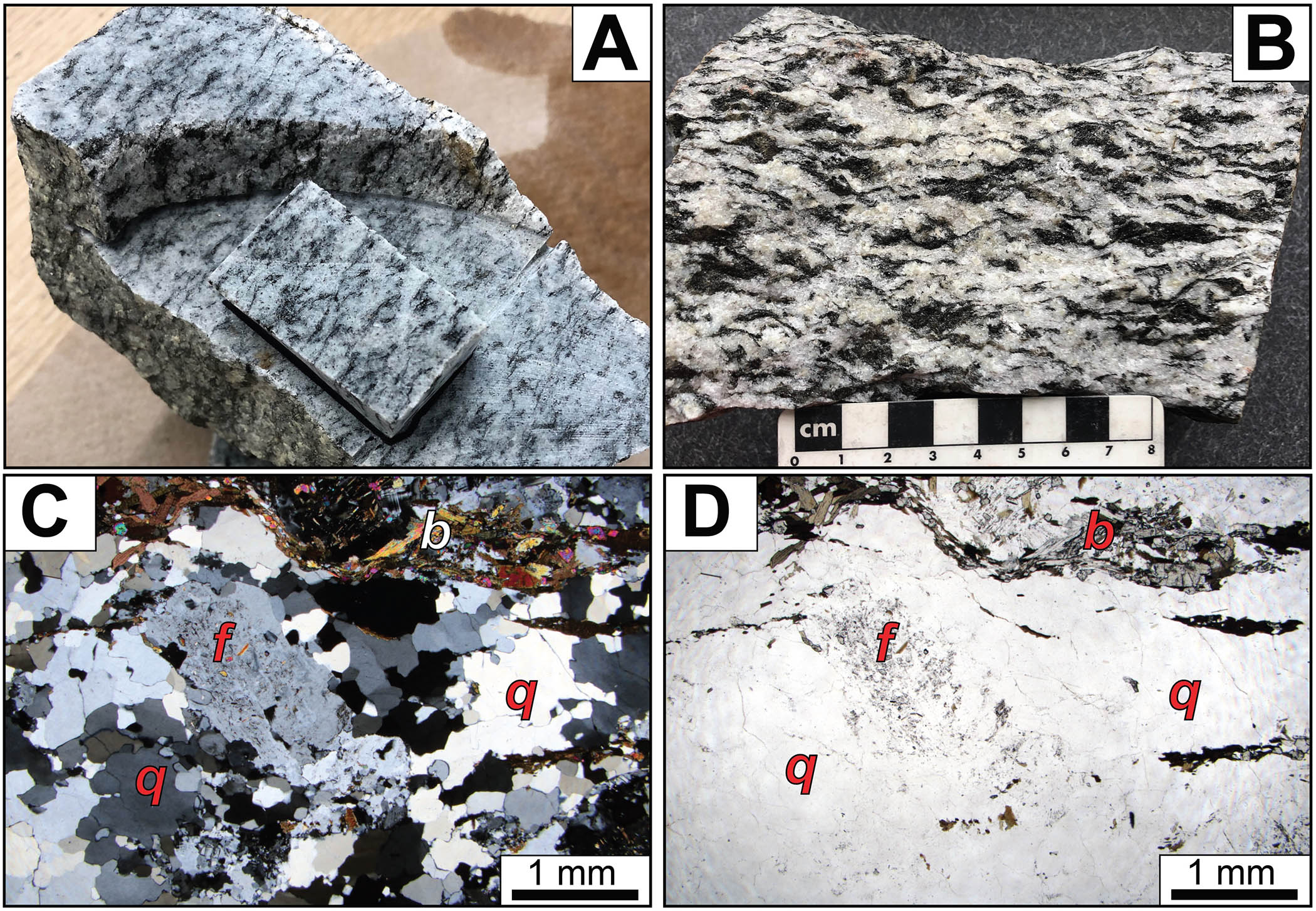
A) Hand sample and thin section billet (~2.5 x 4.0 cm) from HRBTE-1, B) Hand sample of coarse-grained well-foliated granitic gneiss from HRBTE-2, with weakly developed shears bands. C) Petrographic thin section of sample HRBTE-1 with feldspar (f) phenocryst, polycrystalline quartz (q), and biotite aggregate (b) in cross polarized light. D) Sample HRBTE-1 in plane polarized light.
Fort Monroe, constructed between 1819-1834, is the largest stone fort in the United States — it’s an impressive fortress with a long history and is well worth a visit. I first visited Fort Monroe in August of 2021 and examined the massive ashlar blocks which form the bulky walls on the outer parapets as well as the interior walls of the casemate. The vast majority of Fort Monroe’s hewn stone architecture is granitic gneiss of the same ilk as that recovered from the shipwreck.
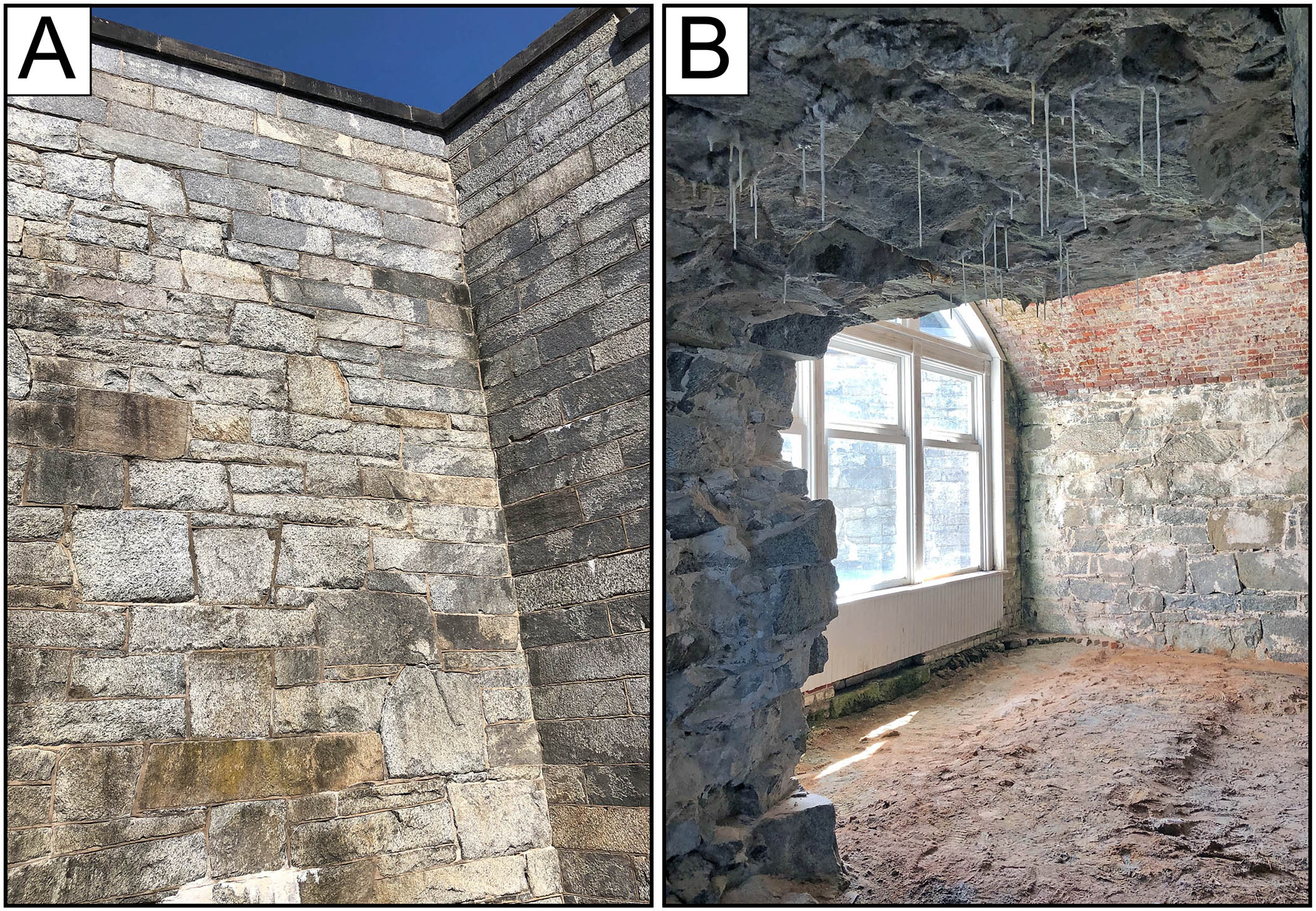
A) Massive stone rampart at Fort Monroe (height of the wall is ~8 meters) constructed primarily of worked blocks of Port Deposit Gneiss. B) Interior view of a casemate at the southern end of Fort Monroe. Note the small, irregularly-shaped stone blocks of Port Deposit Gneiss in the far wall and ceiling in the foreground. Interestingly, there are ‘soda-straw’ stalactites of calcite hanging from the ceiling, these form via dissolution of the Ca-rich mortar between the stone and re-precipitation as the ion-rich fluid drips from the ceiling.
Two kilometers south of Fort Monroe, out in the middle of Hampton Roads, there is a second fort built upon the Rip-Raps shoal. Originally named Fort Calhoun, but later changed to Fort Wool during the Civil War, the fort is sited on an artificial island built from stone blocks that were quarried elsewhere, transported to Hampton Roads, and dumped on the shoal to create land. Under a leaden sky on a late October afternoon, I reached Fort Wool by boat (transport courtesy of the Virginia Department of Wildlife Resources); the site is currently managed as a bird-nesting location and our visit was timed to miss the nesting interval. Fort Wool is a surreal spot perched in the middle of Hampton Roads, it’s a fabulous vantage point from which to watch the never-ending parade of both oceangoing ships and local boats going to-and-fro.
The island consists of heterogenous rock rubble, some of which includes worked blocks. The rock rubble contains a distinctive foliated granitic gneiss similar to that at Fort Monroe and from the shipwreck. However, the rock rubble on Rip-Raps Island is a diverse lot with blocks from numerous sources. Fort Wool’s 19th century suprastructure is constructed from large, high-quality worked stone blocks. The upper courses of stonework are a dark gray, hornblende-bearing gabbrodiorite while the lower courses are a whitish to pinkish gray, medium-grained granite. Neither of these rock types occur in the shipwreck.
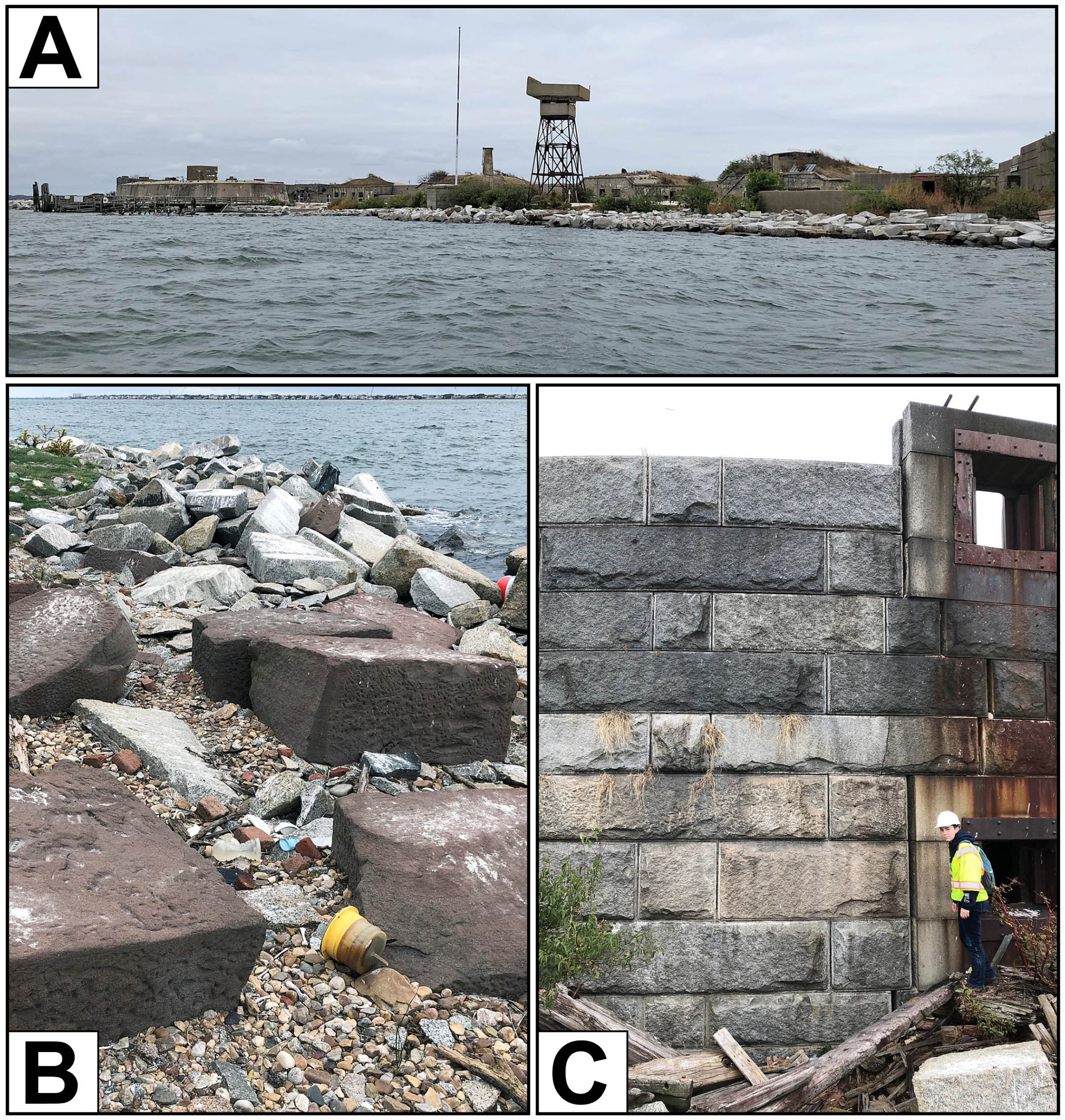
A) View of Fort Wool from the south, note the large stone blocks in the foreground that make up the island. B) Heterogenous stone rubble of the west side of Rip-Raps Island. The dark brown blocks are Triassic sandstone (Seneca sandstone) from the northern Culpeper Basin near the Potomac River to the northwest of Washington D.C. The white blocks are Port Deposit Gneiss. C) The original stone suprastructure at the northwest end of Fort Wool with the lower courses of stone composed of a light-colored massive granite. The four upper courses are a dark gray gabbrodiorite from the Georgetown Intrusive Suite in Washington D.C. W&M geologist Terri Zach for scale.
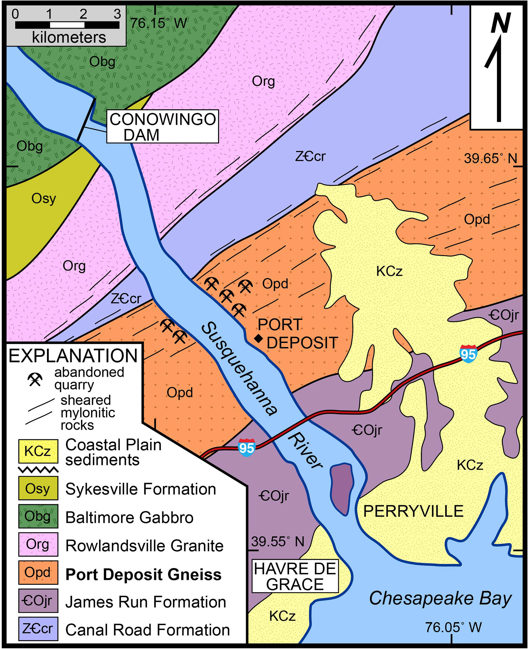
After my first examination of the recovered stones, I was confident as to its source. To my eye, these rocks were quarried from the Port Deposit area along the Susquehanna River in northern Maryland. Dimension stone quarries operated along both sides of the Susquehanna River near Port Deposit since the late 18th century. These quarries are located below the Falls of the Susquehanna River (at the base of the Fall Zone) and just a few miles from the upper Chesapeake Bay which provided an easy means to transport (by ship) quarried blocks to distant locations. The Port Deposit Gneiss is a distinctive black and white stone that’s been used in numerous building projects throughout the Mid-Atlantic region.
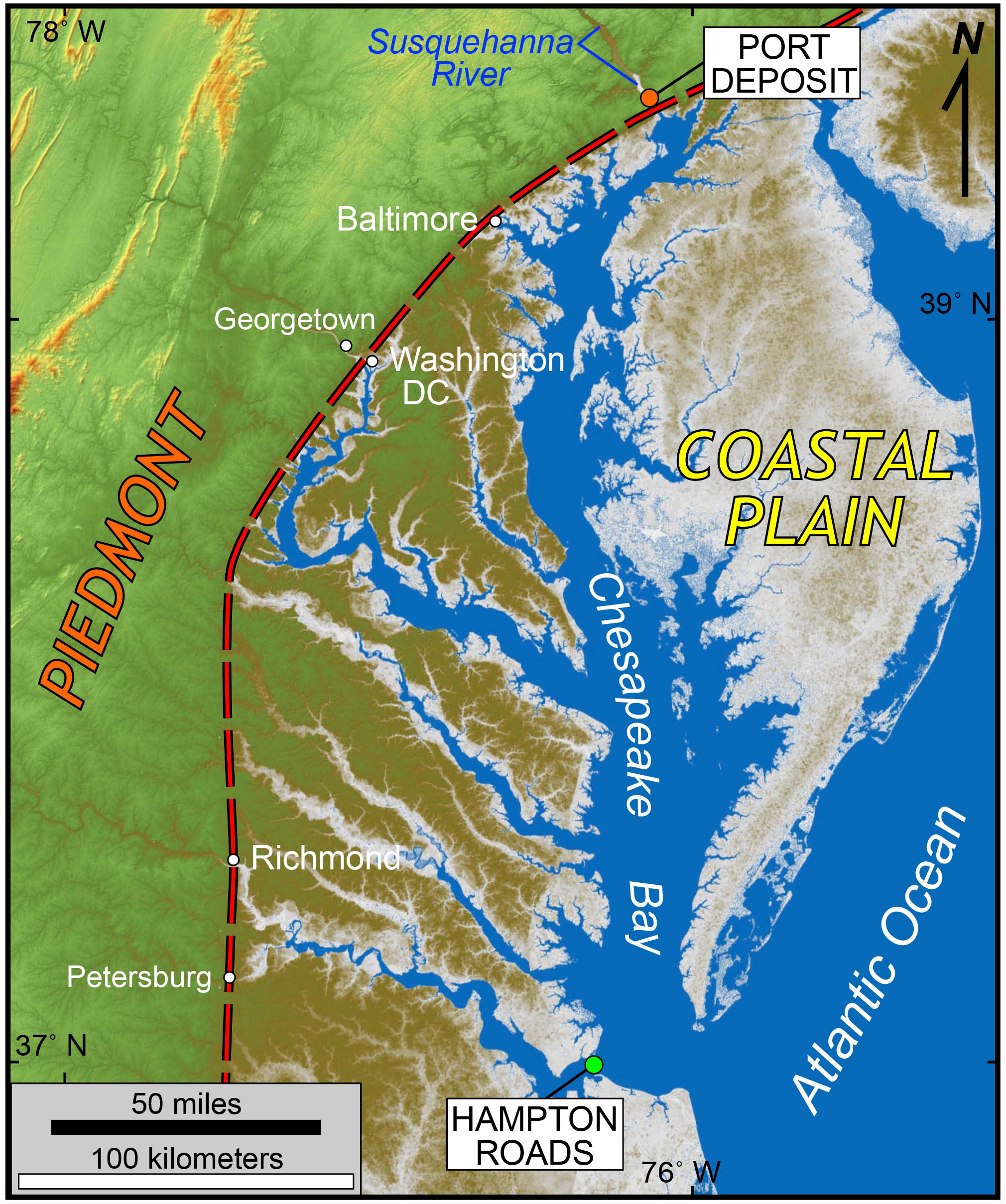
Overview map with the Hampton Roads study site and Port Deposit illustrated. The dashed red line is the base (eastern edge) of the Fall Zone.
In December 2021, I journeyed to Port Deposit and examined a number of old quarries as well as historic buildings and other stone structures in the area. Rock exposed in the old quarries are a variably foliated and systematically jointed granitic gneiss. Both at the mesoscale (hand sample) and microscale (thin section) the rocks at Port Deposit are identical to the samples from the shipwreck. By the mid-20th century, dimension stone quarrying in the Port Deposit area had run its course, but its stone buildings and monuments still stand throughout the Mid-Atlantic region.
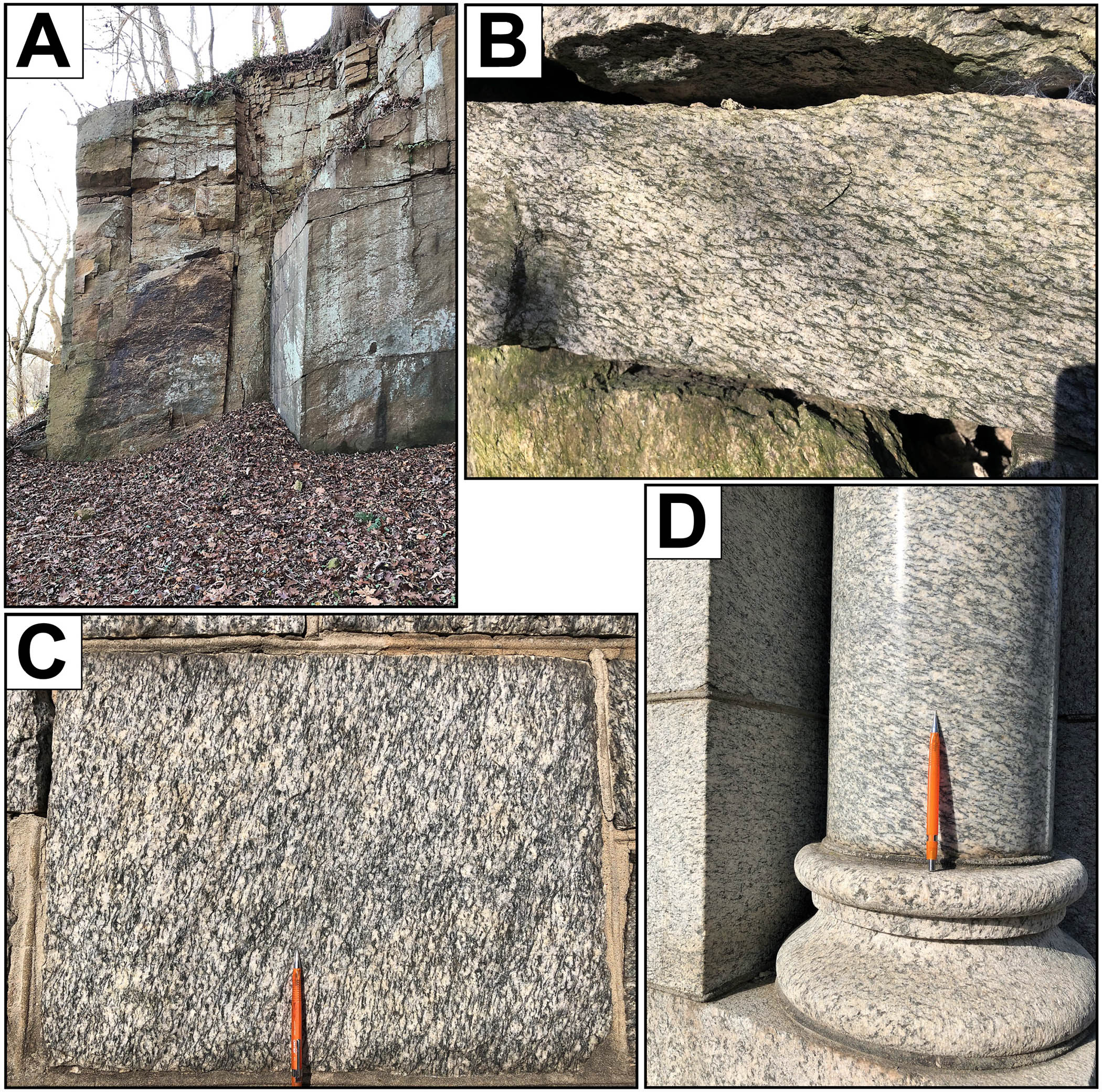
Photos from the Port Deposit area. A) old quarry with steeply dipping joint faces cutting foliated granitic gneiss. Height of wall is ~4 m. B) Close-up of foliated granodioritic gneiss with shear bands from quarry picture in A. C) worked block of foliated granodioritic gneiss on the Port Deposit Town Hall. D) polished decorative column with base and ashlar block in Port Deposit.
To better characterize the rock, I conducted whole-rock chemical analysis of an array of samples. Chemically, the blocks from the shipwreck are matches to samples from Port Deposit which also match the Fort Monroe samples and some of the Fort Wool rubble. However, the blocks that comprise Fort Wool’s suprastructure are quite different and definitely not sourced from the Port Deposit area. The gabbrodiorite at Fort Wool is likely from the Georgetown Intrusive Suite, long quarried along the Potomac River near Georgetown, while the granite may be from the Petersburg batholith, long quarried at sites near Richmond or Petersburg.
Nearly all of the shipwrecked blocks are rectangular to sub-rectangular in shape. Typically, faces on opposite sides of a block are parallel and likely natural fractures (joints), some blocks have two sets (4 faces) of natural joints. Joints aid in quarrying dimension stone as they form planar zones along which the rock can be split. The blocks also contain a penetrative foliation that developed as these rocks were sheared and metamorphosed.
By measuring the 3D orientation of the foliation and joints in the recovered blocks, I could compare the orientation of these structures to the actual orientation of foliation and joint sets at the Port Deposit quarries. Stereographic projection analysis, I’ll spare the gory details, enabled me to determine that the angles between the structural elements in the recovered stone blocks is geometrically similar to the actual orientation of structures in the bedrock at Port Deposit, providing yet another indicator as to the stone’s provenance.
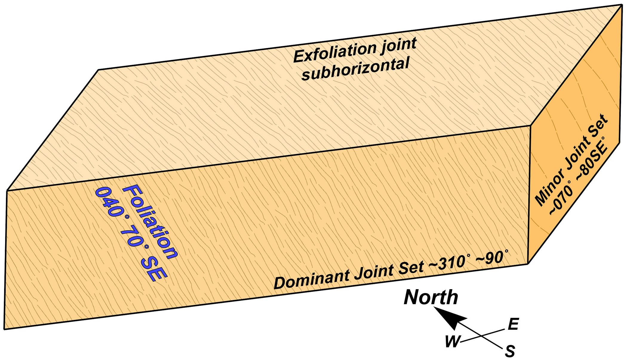
Schematic block of Port Deposit Gneiss from the shipwreck. Blocks are typically faced by two joint sets and an exfoliation joint. Foliation is a penetrative feature defined by aligned minerals that occurs throughout the rock. Attitudes of rock structures are given in their actual orientations from the Port Deposit area.
Let’s step back for a moment, the quarried stone blocks discovered in the muck on the Hampton Bar originally crystallized and became plutonic igneous rock 475 -to 480 million years ago. The Port Deposit pluton formed deep in a volcanic arc complex of Ordovician age that accreted to the edge of North America during the Taconian Orogeny (~440 to 455 Ma). Some 175 to 200 million years later, these rocks were deformed and metamorphosed to gneissic rocks during the late Paleozoic Alleghanian Orogeny.
Simplified geologic map of the Port Deposit area in northern Maryland (modified from Orndorff (1999) and Lesser (1982)).
Eventually, these rocks, which formed at great depth, were exhumed to the Earth’s surface, and in the early 19th century were quarried in northern Maryland. Once quarried, the stone blocks were loaded onto a wooden schooner and shipped south along the length of the Chesapeake Bay, only to be lost in a shipwreck on the Hampton Bar – less than a kilometer from their intended destination at Fort Monroe. That’s quite a journey through both time and space.
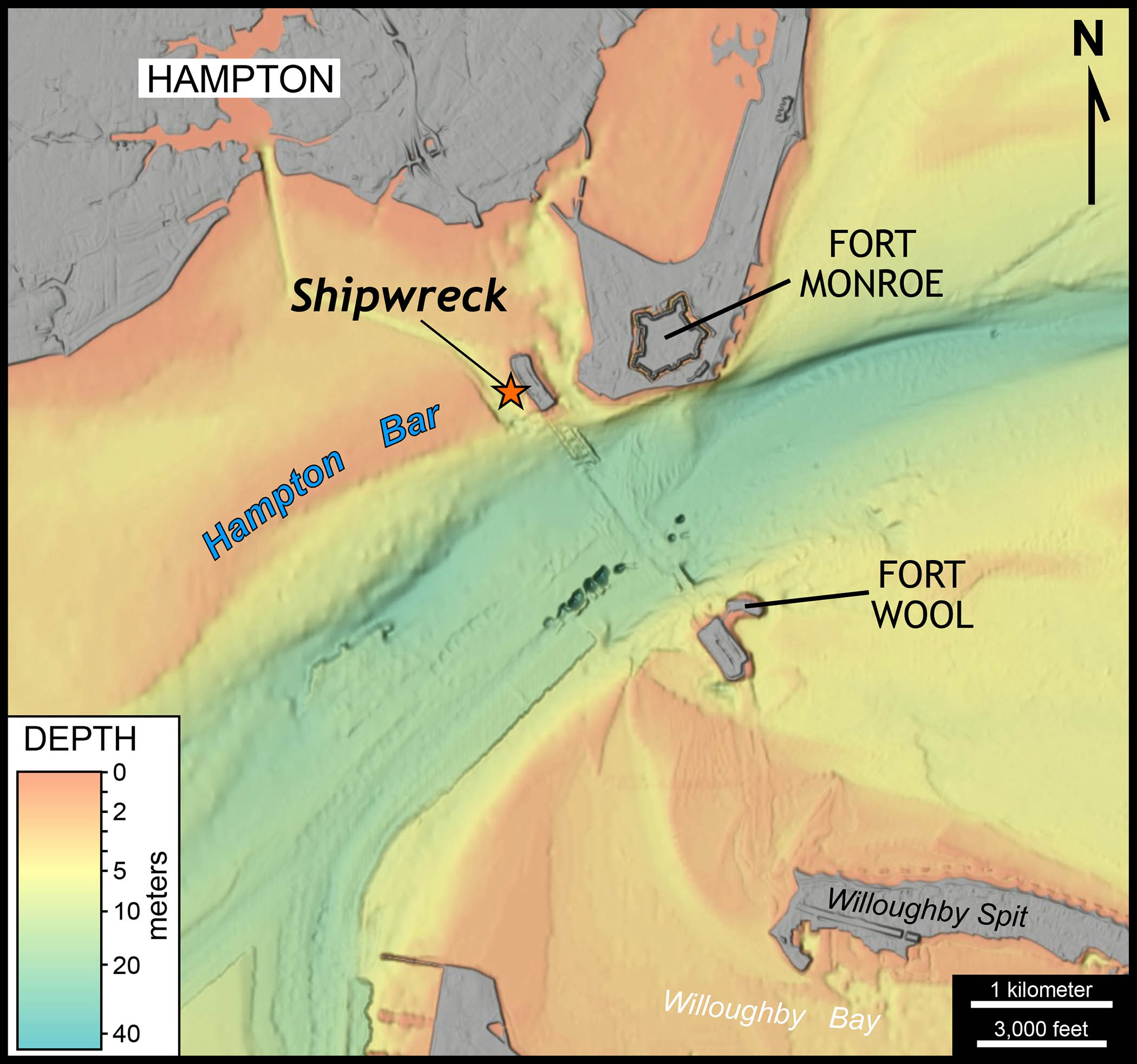
A modern bathymetric map of Hampton Roads and the HRBTE shipwreck site on the Hampton Bar. Data from NOAA.
My research on the shipwrecked rocks in Hampton Roads was just one component of a larger study that included historic archival research, dendrochronology, and forensic marine architecture.
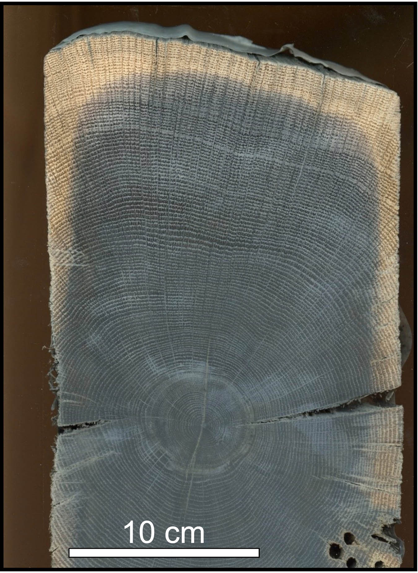
Tree rings from a recovered ship timber (Carol Griggs photo).
Dr. Carol Griggs at Cornell University determined that the ship’s timbers are oak (of the white oak group) and used large cross sections of 8 timbers to determine the chronology. One piece from the forefoot knee timber contained 342 rings. Two key findings emerge from the dendrochronology – 1) the youngest growth ring in the timbers formed in 1816 which sets a maximum age for the vessel and 2) these oaks were likely sourced from mature forests in northeastern Pennsylvania.
Maritime archaeologist Dr. Gordon Watts reported on the timbers and structure of the vessel. It’s important to consider that much of the shipwreck was not recovered, so Dr. Watts was working with just parts of the vessel in his effort to reconstruct the whole. The major conclusions are that the vessel was schooner-rigged (a two masted ship) which is larger than a sloop (a single masted ship) that had been inferred by a previous study of the shipwreck. The vessel also included a distinctive forefoot knee which is an angular timber used to reinforce the structure at the forward end of the keel. It’s a unique design with a curious pattern of fastening the floor timbers, perhaps characteristic of a specific shipwright or shipyard.
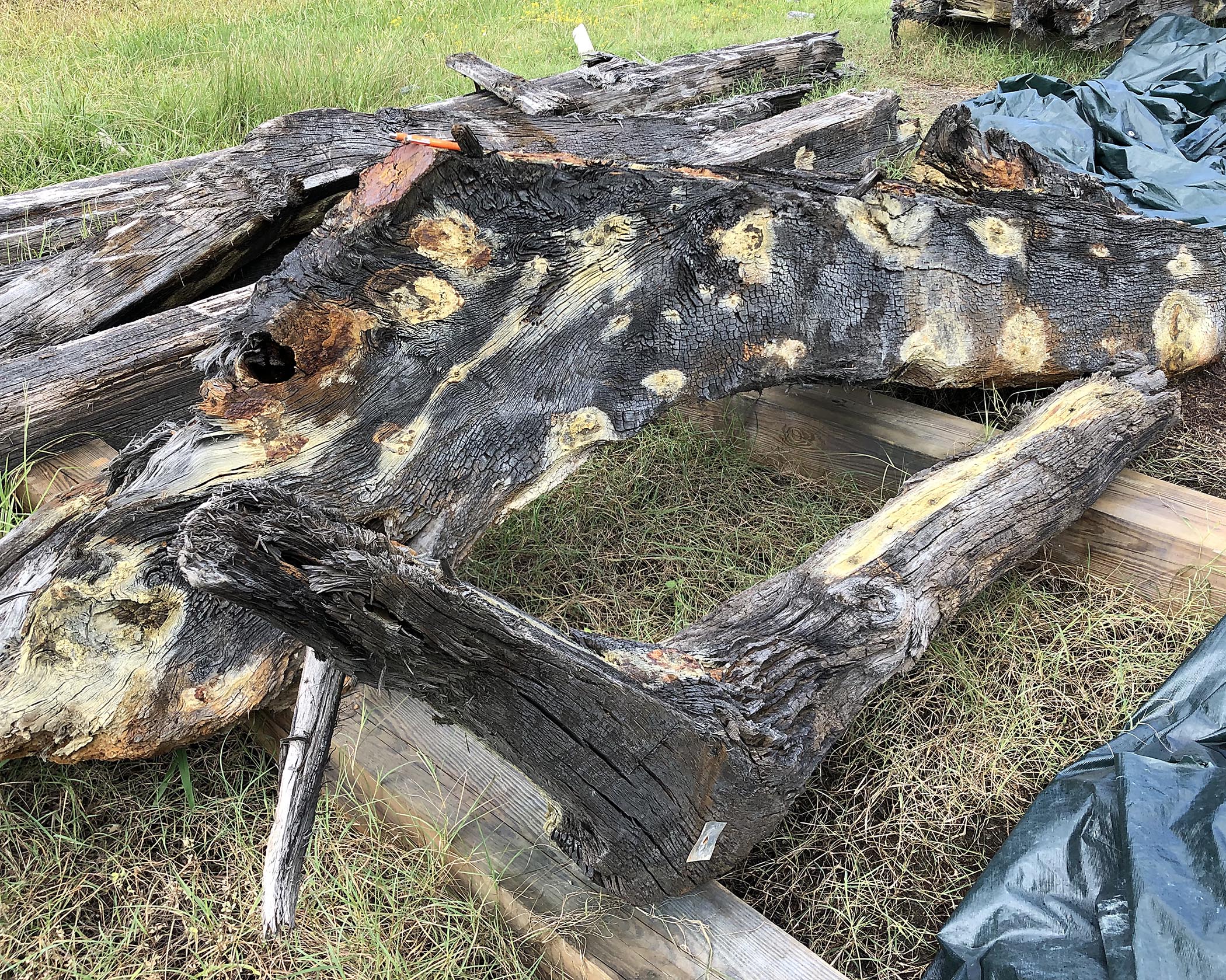
Recovered ship timbers at the VDOT storage facility.
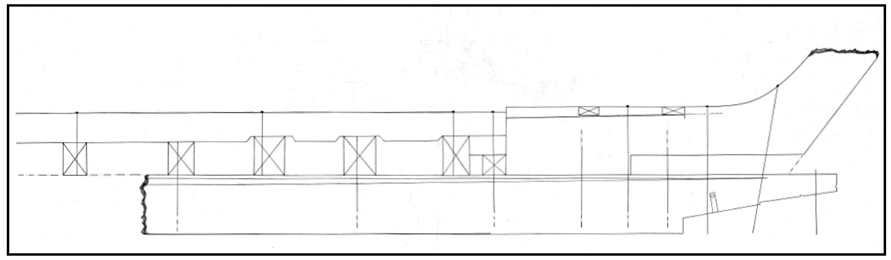
Line drawing of the reconstructed bow of the shipwrecked vessel by Dr. Gordon Watts.
Some of these shipwrecked stone blocks will soon become part of the William & Mary Rock Garden here on campus. I’m excited as these stones tell a fabulous story, one that weaves together both geologic time and human history.
Acknowledgements
This study was made possible by support and funding from the Virginia Department of Transportation and the Federal Highway Administration. VDOT personnel facilitated access at the Chesapeake storage yard. Will Moore, VDOT’s lead archaeologist, helped make this project a reality. Thanks to David Stroud, Ali Kolleda, and Paul Presenza for providing a gracious and informative tour of Fort Monroe. The Virginia Department of Wildlife Resources arranged access as well as transportation to and from Fort Wool. I’m indebted to Michael Cobb, former director of the Hampton History Museum, for his insight and perspective during the project.
It was fabulous to collaborate with historian David Lewes and archaeologist Thomas Higgins at William & Mary’s Center for Archaeological Research on this project. Elizabeth Monroe and Joseph Jones, also of W&MCAR, helped oversee the project. Terri Zach provided both technical assistance and wry humor on the field excursions to Fort Monroe and Fort Wool — many thanks.
The Report
Lewes, D.W., Higgins, T.F., Watts G.P., Bailey C.M., and Griggs, C.B., 2022, Archaeological data recovery of site 44HT0125, associated with the I-64 Hampton Roads Bridge Tunnel Expansion Project, City of Hampton Virginia: W&MCAR Technical Report Series No. 37, 186 p.
References Sited
Lesser, R., 1982, Major element and isotopic studies of the James Run/Port Deposit association, Maryland: tectonic assemblages and Taconic deformation: Virginia Polytechnic Institute and State University, Blacksburg, Virginia M.S. thesis, 197 p.
Orndorff, W.D., 1999, Crystalline bedrock of the lowermost Susquehanna Valley: Implications for the tectonic assembly of the central Appalachian Piedmont in The Mid-Atlantic Piedmont: Tectonic Missing Link of the Appalachians, eds. Valentino, D.W., and Gates, A.E.: Geological Society of America Special Paper 330, https://doi.org/10.1130/0-8137-2330-2.73


No comments.
Comments are currently closed. Comments are closed on all posts older than one year, and for those in our archive.