
Glimpses of the Past: The Rockfish Conglomerate
My family has a tradition of going camping about once per semester. Back in the spring of 2011, as the Appalachians were beginning to green up, we headed west to Rockfish, Virginia for a weekend camping trip to my Uncle Joe’s farm. Joe’s farm is located in the foothills of the Blue Ridge Mountains and I’d call the scenery sublime.
Bedlam reigned as we unpacked and set up camp, so much bedlam that I needed quiet time alone. Off I set on a hike through the woods. A half-mile of hiking brought me to the verge of this old abandoned quarry.
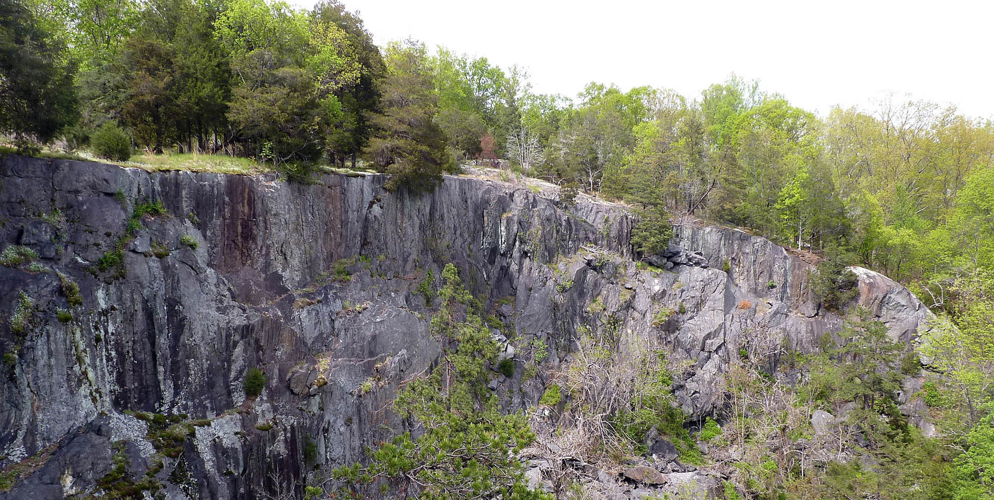
View to the northeast of abandoned rock quarry near Rockfish, Virginia.

Large clasts of granite in Rockfish Conglomerate. Length of hammer is ~40 cm (16″).
It was a commanding view with spectacular rocks exposed in the walls of the quarry. The bedrock here is a metamorphosed conglomerate, a coarse-grained conglomerate chock-a-block full of clasts, many larger than basketballs. The clasts are fragments of older rocks that were eroded, transported, and deposited long ago.
The conglomerate is stratified, but the layers have been tilted and are lying on end. These layers were tilted past vertical and are overturned – that is, the older layers are structurally above the younger layers (an inverted stratigraphic sequence).
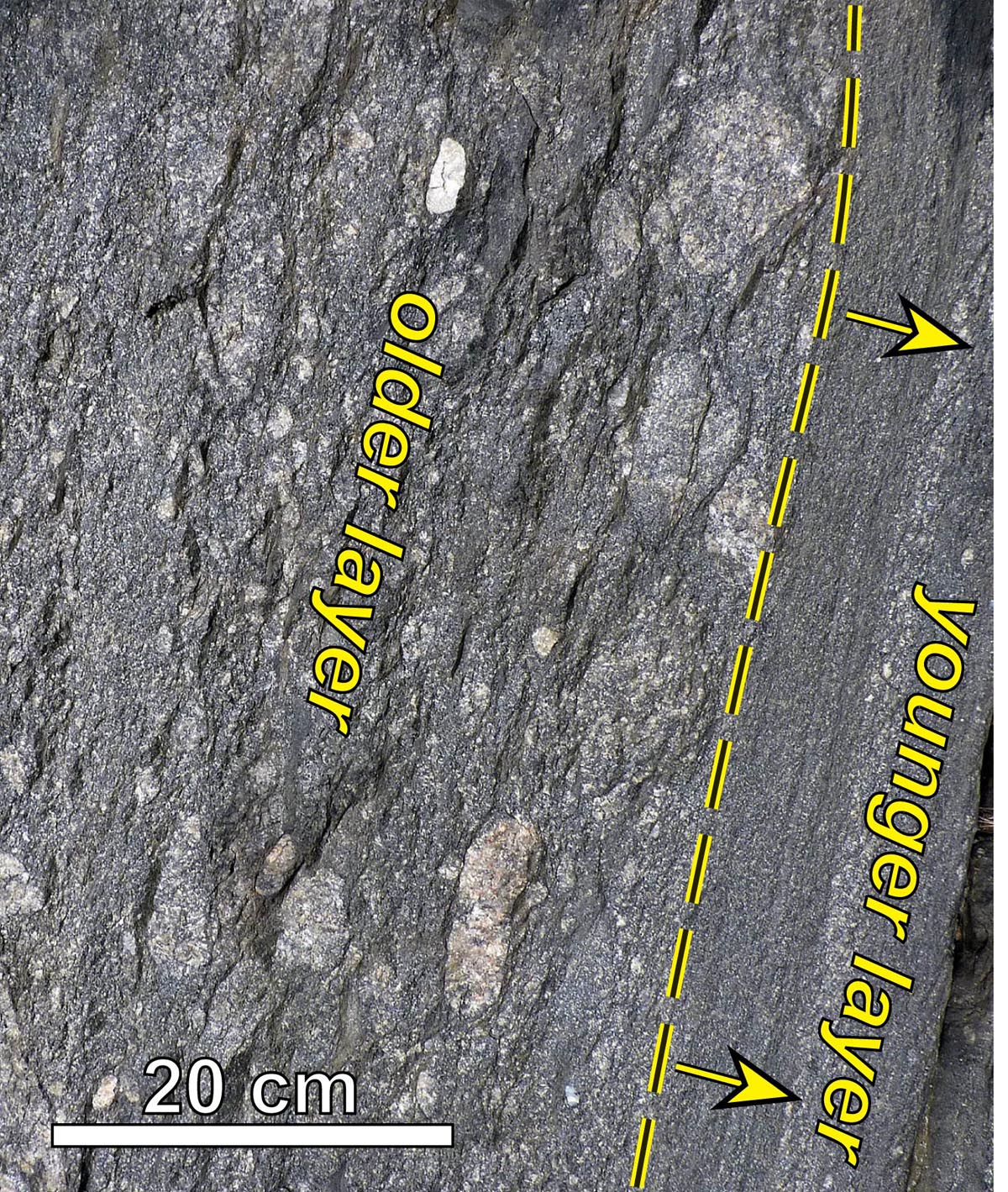
Overturned strata in the Rockfish Conglomerate, notice younger layer below older layer.
I was giddy with geologic questions. In what depositional environment was this conglomerate deposited? Why are these layers tilted and overturned?
The quarry I’d stumbled upon exposes the Rockfish Conglomerate, a geologic unit in the eastern Blue Ridge first defined by Wilbur Nelson in 1932 for outcrops along the Rockfish River about a kilometer to the southwest (geologists commonly name stratigraphic units for a particular location where the rocks are first described and typically are well exposed, it’s known as the type location). This curious conglomerate has been studied by a number of geologists, but nowhere could I find any reference to the exposure at the quarry.
Since the “discovery” I’ve taken classes to see these rocks and invited other geologists to these outcrops. Callan Bentley at Northern Virginia Community College wrote a blog post and captured a lovely Gigapan image from an early visit to the quarry. Just last year Zach Foster-Baril decided to tackle the Rockfish Conglomerate as his senior research topic. Zach just presented the results of this work as a talk last week at the Geological Society of America’s annual meeting in Denver.
We have learned much from our field and lab work over the past year. Our geologic mapping reveals that the Rockfish Conglomerate was deposited in a trough that was eroded into the underlying and older granitic basement rocks. The trough was later filled with the coarse sediment that became the Rockfish Conglomerate. Years earlier I’d posited that the contact between the basement rocks and the overlying metasedimentary cover rocks was a fault, but Zach’s detailed field data make it clear that the boundary is an unconformity.
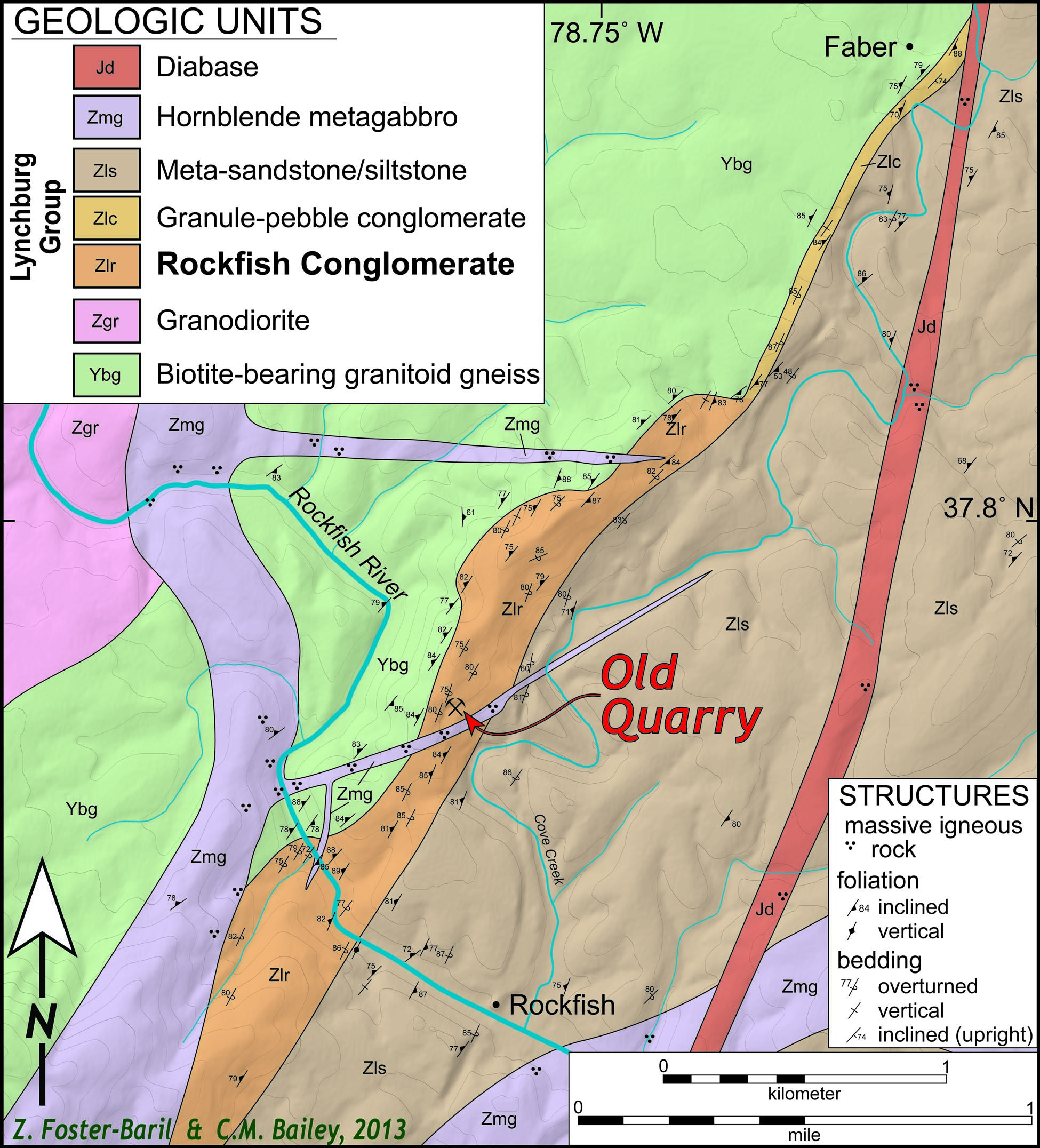
Zach and Chuck’s geologic map of the Rockfish area, Virginia. Click for larger view.
As the rocks in the Rockfish area are tilted into an almost vertical orientation we can turn the geologic map on its side to approximate the original geometry of this sequence.
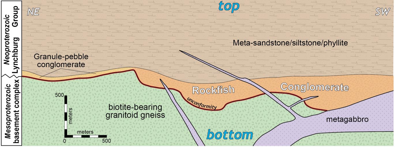
Rock units in the Rockfish area “tilted” to their original orientation when the sediments were deposited.
Instead of north, south, east, and west we’ve got stratigraphic up (top) and down (bottom) with the oldest rocks at the bottom. From this perspective it is clear that the granitic basement rocks (green) originally were beneath the Rockfish conglomerate (orange), which occupies an irregular trough a few hundred meters deep. An intrusive gabbro body (lavender), as sills and dikes, cuts both the granitic rocks and overlying metasedimentary rocks.
In what environment were these sediments (now thoroughly lithified rocks) deposited?
Cobbles and boulders are not easily transported: high-energy processes are needed to move bowling ball-sized rocks. Suitable conditions occur in mountain streams where fast-moving turbulent waters rage during floods. As the torrent reaches the mountain front, the current slackens and the stream’s load of cobbles and boulders is deposited at the mountain front creating a distinctive wedge of alluvial deposits out into the valley.
But fast moving water effectively sorts sediment based on its grain size. Particles of similar size are deposited along with each other; so as pebbles are deposited, the sand and mud (the smaller particles) continue to be transported by the flowing water. The Rockfish Conglomerate is a very poorly sorted rock and lacks many of the sedimentary structures we’d expect in alluvial fan deposits.
In the 1980’s Frederick Wehr, at the time a graduate student at Virginia Tech, studied the exposures along the Rockfish River and concluded that the sequence was not a terrestrial alluvial fan deposit, but rather a subaqueous marine deposit formed from glacial outwash and mass flow turbidites. Our observations at the quarry are consistent with Wehr’s interpretations. A glaciomarine origin for these rocks is compatible with 1) the wide range of grain sizes (boulder to silt/sand), 2) the prominent parallel stratification present throughout the Rockfish Conglomerate, and 3) the conformable nature of the overlying strata in the Lynchburg Group.
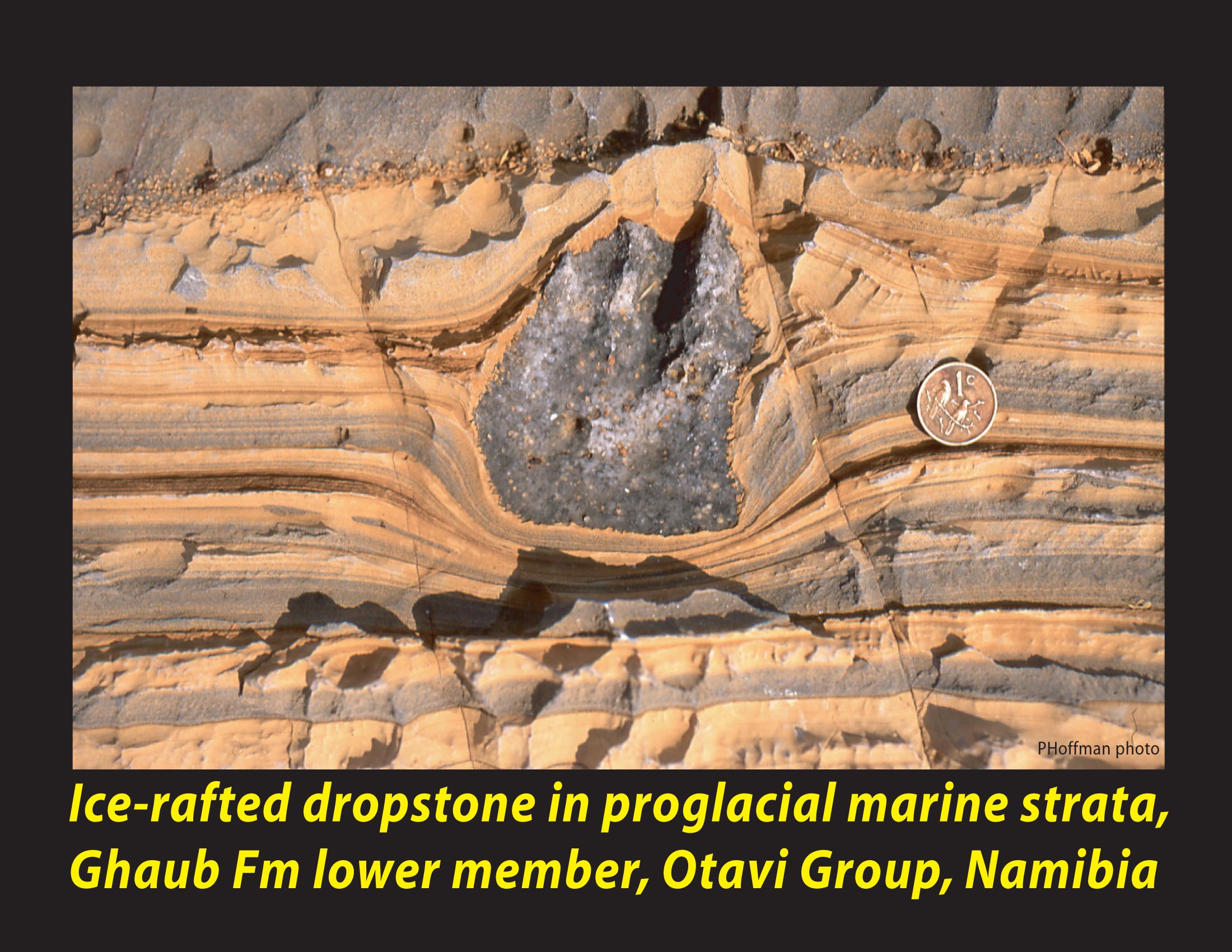
After the talk my colleague Michelle Markley from Mt. Holyoke College plaintively asked Zach to show the audience some dropstones.

Ice rafted dropstone in proglacial marine strata from Neoproterozoic strata in Nambia. Photo by Paul Hoffman. http://www.snowballearth.org/slides/Ch1-21.jpg
Dropstones are literally stones dropped from above into sediment layers at the bottom of a lake or ocean. They are inferred to form when rock laden lake or sea ice rafted off glaciers melts, thereby “dropping” the sediment, from boulders to mud, that was entrained in the ice. Dropstones commonly deform or deflect the underlying strata and are draped by younger layers of sediment. These sedimentary features are not only visually stunning, but typically taken as key evidence for glaciogenic sedimentation into a basin.
Michelle’s question was right on point, we’d not offered up any dropstones for viewing.
Individual dropstones (called by some geologists – lonestones) are not common in the Rockfish Conglomerate. The picture below highlights a candidate for a Rockfish dropstone, but it won’t win any dropstone beauty contest.
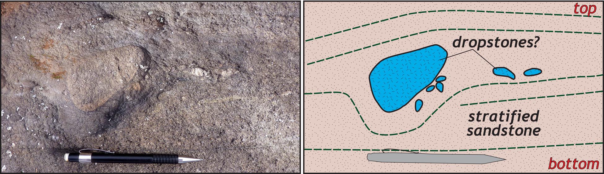
Dropstones (?) in the Rockfish Conglomerate. Field photo on left, annotated sketch on right.
A few plausible reasons for the lack of readily identifiable dropstones in the Rockfish Conglomerate include: 1) the coarse conglomerate was deposited in a proximal position relative to the glacial ice and as such the flux of coarse-grained sediment was huge, 2) abundant ice-rafted debris falling into a coarse mixture of sand is less likely to stand out as a dropstone when there are lots of clasts (no lonestones here), and 3) these rocks experienced later deformation and metamorphism such that the matrix is a recrystallized mixture of quartz and mica which does not preserve fine-scale details of the depositional environment.
Zach’s research provides new data on the Rockfish Conglomerate, but many questions remain. A few include:
- When was the Rockfish Conglomerate deposited? Stratigraphic relations indicate that the Rockfish Conglomerate was deposited during the Neoproterozoic Era between 570 and 1,000 million years ago. The possible age range for when these rocks were deposited is >400 million years, that’s lousy age control.
- What created the trough in the basement complex into which the Rockfish Conglomerate was deposited? Possibilities include either glacial or fluvial erosion during a low stand of sea level.
- Is the Rockfish Conglomerate associated with widespread glacial episodes that occurred during the Neoproterozoic? The Neoproterozoic was a time of tremendous climate oscillation, some researchers argue for a Snowball Earth in which glacial ice covered much of the planet.
- How much strain/deformation has the Rockfish Conglomerate experienced? Outcrop-scale deformation structures are common. To better understand original sedimentary geology we need to quantify the amount of shortening, stretching, and rotation these rocks enjoyed.
- When was the Rockfish Conglomerate deformed, metamorphosed, and tilted? Regional data suggest these events occurred during the Paleozoic Era, but as with the Neoproterozoic: the Paleozoic encompasses an expansive amount of Earth history.
That is the nature of research – some questions get answered and other new ones arise. The good news is that Gussie Maguire, a Geology/English double major and mystery tweeter, has taken up the charge. Her thesis research is aimed at answering some of the outstanding questions regarding the Rockfish Conglomerate. On we go.


Comments are currently closed. Comments are closed on all posts older than one year, and for those in our archive.
Enjoyed the post! Also, totally worth it for the #schistchucksays twitter info. Nice idea, Gussie!
Nice post and interesting work! Have you seen any glacial striations in any of the clasts? Is the stratigraphic placement of the Rockfish conglomerate similar to that of the Konnarock formation? Do you think they could be temporally related?
Brian,
We’ve not seen any glacial striations, although the clasts show abundant evidence of dissolution along their margins. If these clasts were striated it might be tough to see it. As for the Konnarock Fm., yes the Rockfish Conglomerate is in a similar stratigraphic position. Are they the same age? Well, they are both Neoproterozoic, but that is still long time interval. The Konnarock Fm. clearly has a glacial influence, but it may not be a marine deposit.
Hi Chuck –
It was a long time ago but I did work on these rocks back in the early 80s, mostly along the Rockfish River.
If I remember correctly Fred Schwab published a paper around the same time on similar aged deposits to the southwest in the Grandfather Mountain area which also had some indications of glacial influence.
Nice to see this interesting work online.
All the best,
Fred
So nice to see the Bus Driver still loving Geology!