
Comfortably Disoriented in the Blue Ridge Mountains
Note: this post was written last September after the Fall 2015 Geology Department field trip, however it never got posted. As the Spring semester comes to a close I thought it was time to stop being a slacker and post this long overdue field trip report!
Last week I spent much time at administrative meetings on campus, and in the process learned about authentic assessment, signature learning, and comfortable disorientation – all of which made me comfortably numb. So it was with alacrity that I headed towards the Blue Ridge Mountains on the Geology Department field trip on Friday afternoon.
The William & Mary Geology Department field trip is a tradition that attracts an array of students, and takes us to scenic and geologically exciting locations. Our crew included 38 students, nearly half were on their first geology field trip, but we also had an ample cadre of senior geology majors in the mix. Watch Megan Flansburg’s first-class video of the trip and see for yourself!
This year’s trip visited Shenandoah National Park in the Blue Ridge Mountains. The Blue Ridge tops out with many peaks over 1,000 m (3,280’) in elevation, and the range stands with great relief above the gently sloping and low-elevation terrain of the Piedmont to the east and the Shenandoah Valley to the west.
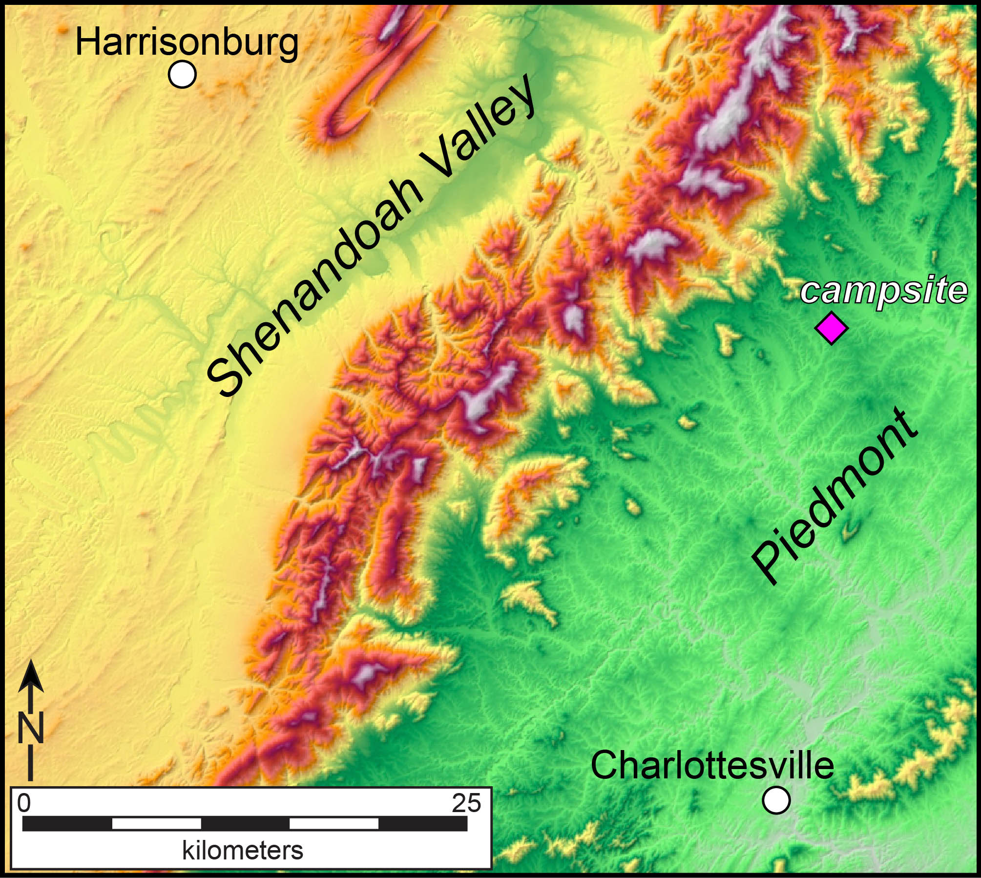
Shaded relief map of the Blue Ridge Mountains in north-central Virginia. The green and yellow are low elevations (>300 m), whereas the deep red to gray are high elevations (>800 m).
On Saturday morning, before leaving our camp, my colleague Greg Hancock and I asked the overarching question of the trip:
“What is the origin of the Blue Ridge Mountains?”
or, crafted in a slightly different fashion:
“Why are the Blue Ridge Mountains there in the first place?”
We solicited hypotheses from the attendees; hypotheses that we’d investigate during our day-long journey through the Blue Ridge. Our plan was to revisit the big question at the end of the day, and collectively discuss which hypotheses were still viable. Then with this newfound knowledge of the Blue Ridge and its geologic history we’d call it a day.

William & Mary geologists enjoying the afternoon sunshine at Blackrock Summit in the Blue Ridge Mountains, north-central Virginia.
Our final stop had us at Blackrock Summit, perched upon blocks of Cambrian sandstone and soaking in the sunshine – a glorious finish to a day in the field. After we’d arrived back on campus, my colleague Becky Jirón noted that we never answered the big question. Somewhere along the way, maybe in the bright sunshine at Blackrock, the faculty had become comfortably disoriented, so much so that we’d completely forgotten to revisit the big intellectual question of the trip.
To atone for that omission, what follows is a discussion about the origin of the Blue Ridge Mountains.
The W&M geologists came up with three hypotheses for the origin of the Blue Ridge Mountains: 1) ancient tectonics, 2) active tectonics, and 3) differential erosion.
The ancient tectonics hypothesis argues that the Blue Ridge was the locus of plate tectonic collision during the formation of Pangaea (way back in the late Paleozoic), this crumpling of the crust created high mountains that have been slowly eroded to their modest modern elevations. The second model relies on active tectonics, modern earthquakes and faulting, to raise the mountains above the surrounding lowlands. The differential erosion model posits that the Blue Ridge Mountains are underlain by strong rocks that erode slowly, whereas the weak rocks that underlie the Piedmont and Shenandoah Valley erode more quickly. Over geologic time topographic relief is created, and the Blue Ridge becomes a mountain range.
Ancient tectonics hypothesis
Rocks that underlie the Blue Ridge Mountains are both old and deformed. The granitic rocks exposed at our first stop on the Skyline Drive crystallized deep in the Earth some 1,000 million years ago, while the youngest rocks in Shenandoah National Park are tough and durable quartz sandstones, deposited in a shallow sea during the early Cambrian period (~530 million years ago). Collectively, these rocks were crumpled and metamorphosed, as well as sheared and faulted during a prolonged tectonic collision that ultimately welded northern Africa to eastern North America, in part creating the massive Pangaean supercontinent. By the late Paleozoic (~250 million years ago), the geologic structures that comprise the Blue Ridge were formed, but at that time the rocks we currently find at the Earth’s surface were buried under many kilometers of rocks.
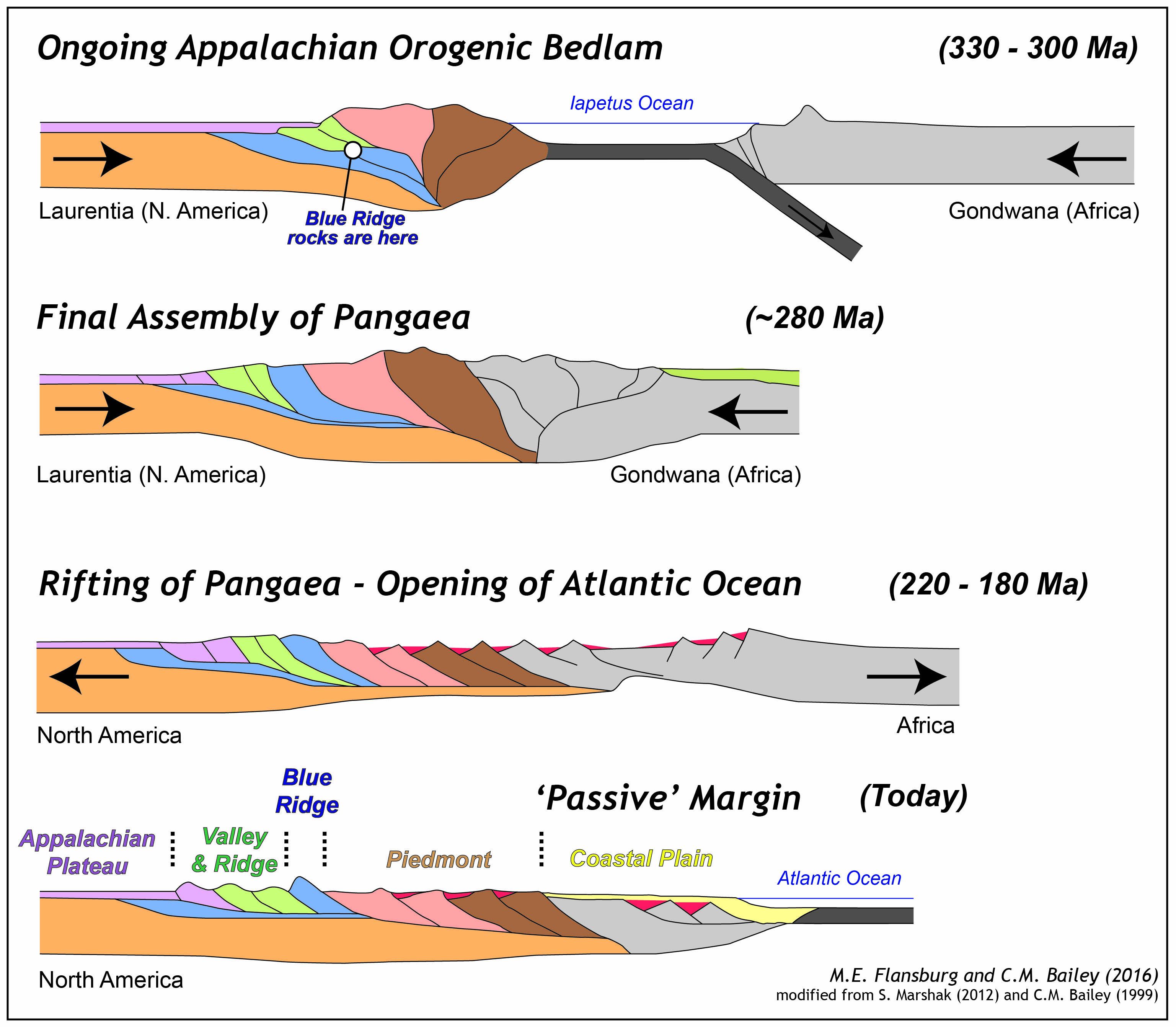
Simplified cross sectional view of the Appalachian orogenesis and Atlantic rifting in eastern North America.
But rocks in both the Piedmont and Shenandoah Valley also enjoyed deformation during the late Paleozoic. Most geologists reckon the suture between Africa and North America lies well to the east of the Blue Ridge Mountains, although crustal deformation occurred across a belt hundreds of kilometers wide. The Blue Ridge region was not the locus of ancient tectonics in the central Appalachians. Rocks in the Piedmont were strongly deformed, yet today this region is anything but mountainous. These observations cast a long shadow over the ancient tectonics model.
Active tectonics hypothesis
The Himalayas are a mountain range experiencing active tectonics as illustrated by modern earthquakes and faulting. This collision between India and Asia is an ongoing process that shortens and crumples the crust, and, in the process, raises up mountains.
Is a similar process happening in the Blue Ridge today? Somebody mentioned the 2011 Virginia earthquake, a moderate temblor that was located in the Piedmont some 60 kilometers from the Blue Ridge Mountains. But if the truth be told, the Blue Ridge is not a hotbed of modern seismicity. Over the past two decades my research group has studied and mapped many faults in the Shenandoah National Park region, but our studies indicate that most of these structures are ancient faults, not active faults primed for raising up modern mountains.
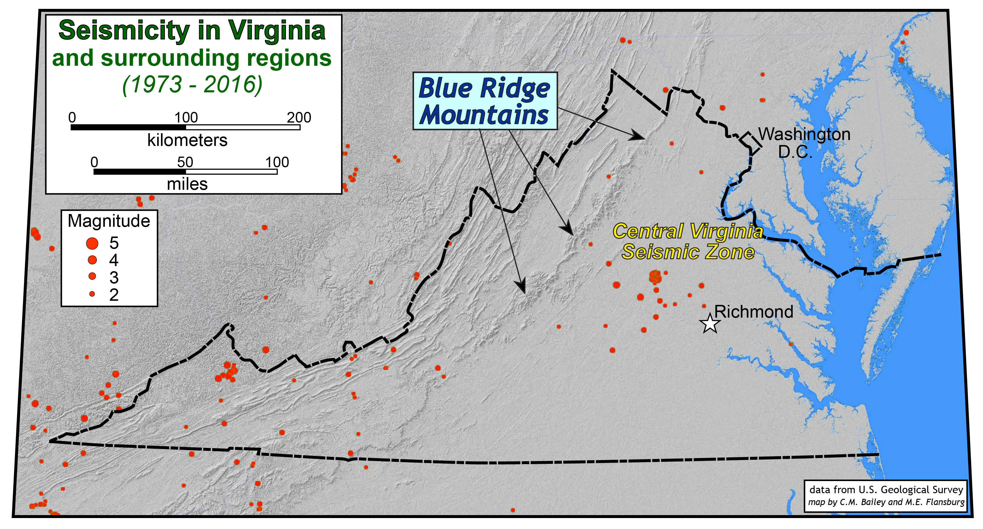
Location of earthquake epicenters (1973 – 2016). The 2011 Virginia earthquake (Mw = 5.8) occurred in the central Virginia Seismic Zone. Notice the paucity of earthquakes in the Blue Ridge Mountains.
Differential erosion hypothesis
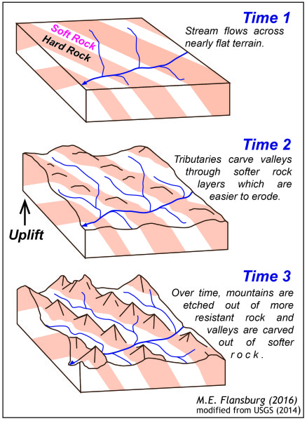
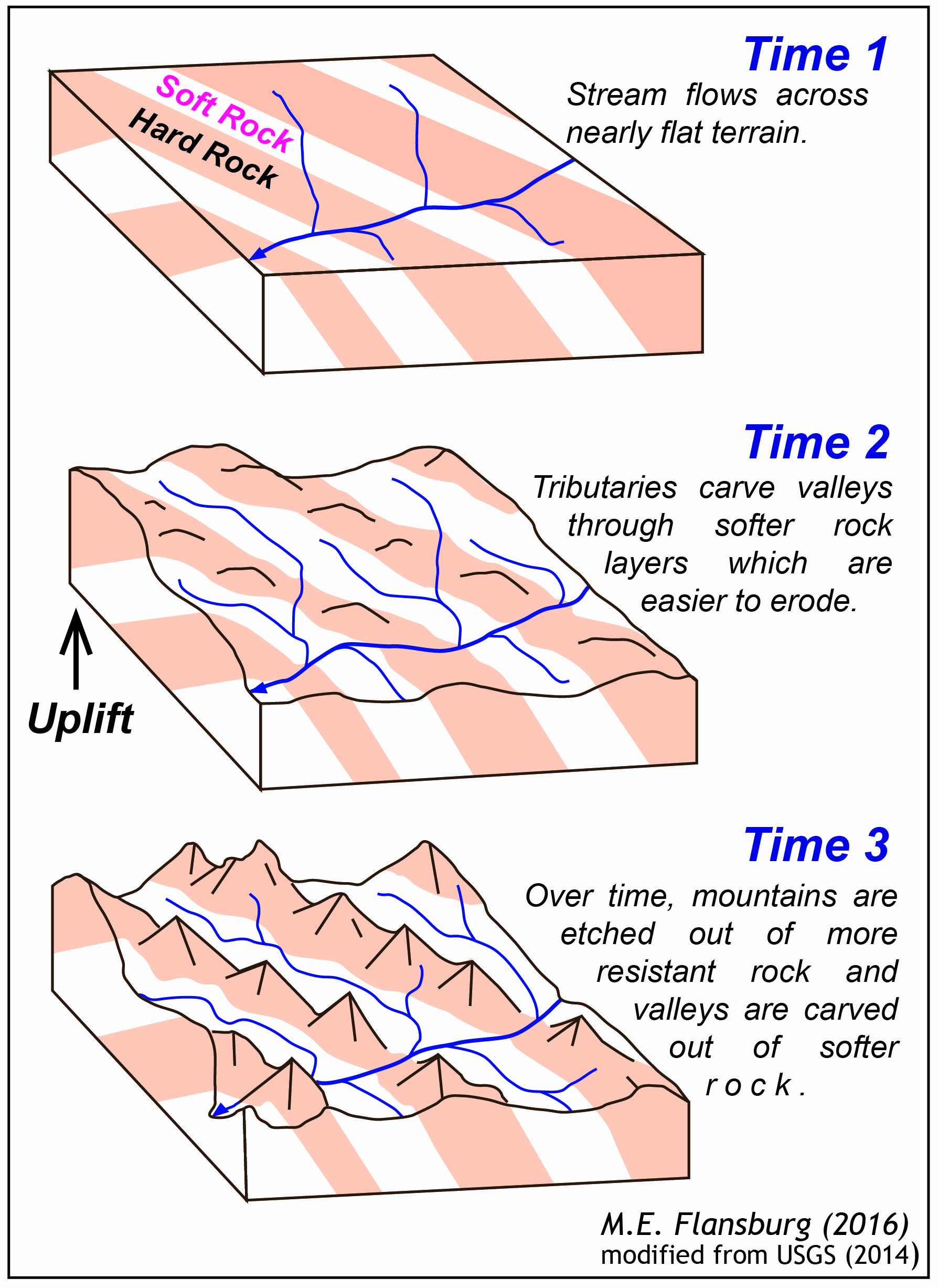
In the Blue Ridge Mountains of north-central Virginia there is a strong correlation between elevation and the underlying rock: 9 out of the 10 highest peaks in southern Shenandoah National Park are underlain by metabasalts of the Catoctin Formation, and 95% of the terrain above 900 meters (>2,950’) is undergirded by the Catoctin Formation. In the Shenandoah Valley, to the west of the Blue Ridge, the bedrock is primarily limestone and dolostone – relatively soft rocks that are prone to dissolution by acidic rain and ground waters, processes that formed the majestic caverns of the Shenandoah Valley.
Studies by Greg Hancock and his students demonstrate that erosion rates on Blue Ridge summits are far lower than basin-wide erosion rates in the valleys. Based on these data, differential erosion is taking place, and the topographic relief between the mountains and valleys is increasing.
The differential erosion hypothesis seems reasonable enough. But in southern Virginia, the Blue Ridge forms an elevated plateau with the same rocks exposed both on the high terrain and in the low terrain to the east.
But what about isostasy?
At our second stop, at an overlook on the Skyline Drive, Greg Hancock brought up the concept of isostasy, it’s an important process that links the deep Earth and the surface. As the Earth’s lithosphere is loaded (say from mountain building or glaciation) the surface and lithosphere are deflected downward. Conversely, as load is removed at the surface the lithosphere ‘rebounds’ upward.
Over geologic time, as material is eroded off the Blue Ridge Mountains the pressure beneath the range is reduced causing the viscous mantle to flow in. Given typical rock densities for the crust and mantle, we’d expect that for every kilometer of erosion that isostatic rebound would provide ~900 meters of isostatic uplift.
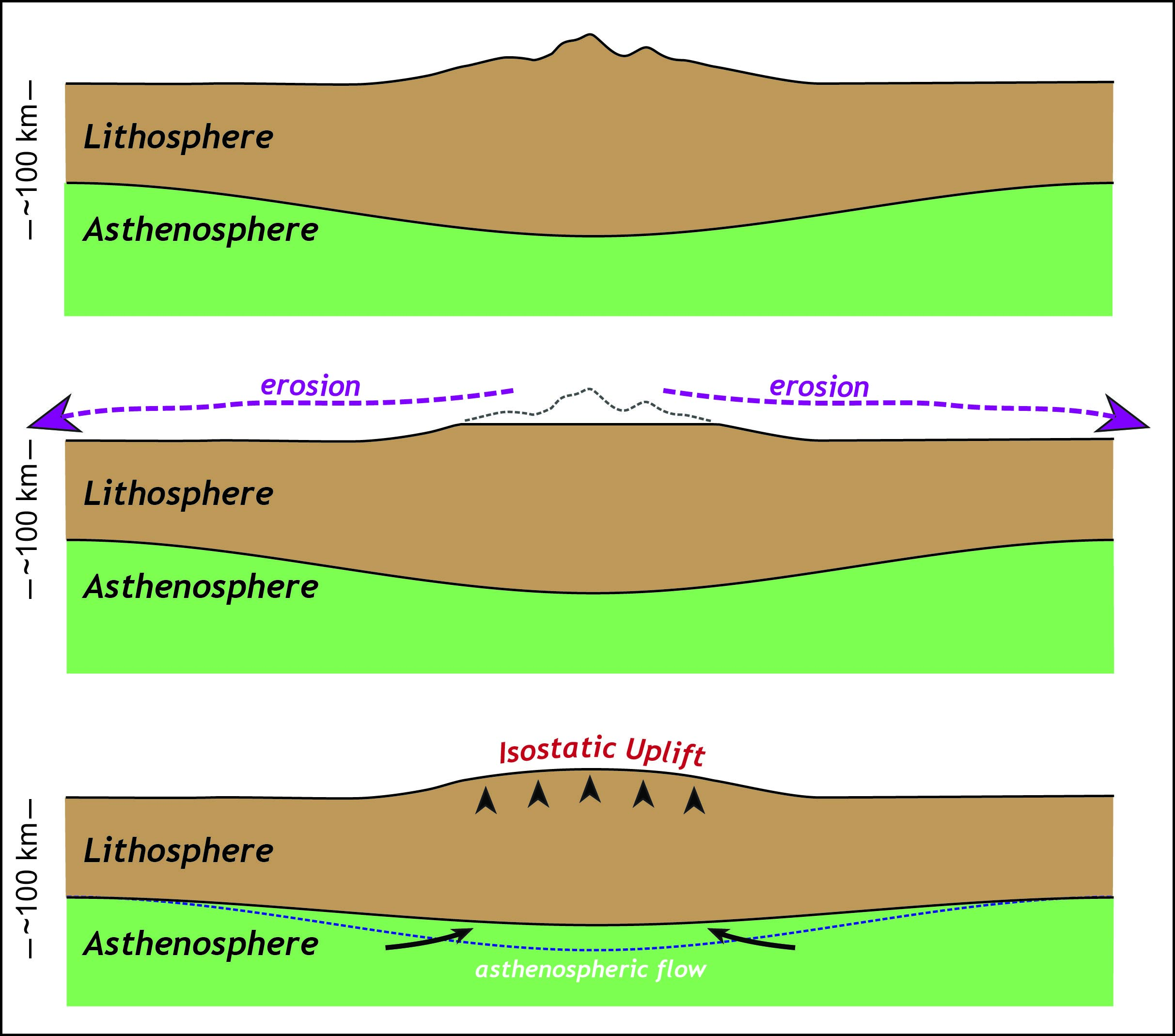
Perhaps isostasy provides the oomph that keeps erosion working on the Blue Ridge Mountains long after tectonic uplift ended.
There is, however, a catch as isostasy operates at a length-scale determined by the thickness of the elastic beam (in the video above it’s the thickness of the yard stick). The Earth’s lithosphere is ~100 km thick, and isostatic uplift/subsidence works over that scale or longer (>100 km). At its widest, the Blue Ridge range in central Virginia is ~30 km, thus the isostatic response is affecting a far larger area than just the Blue Ridge Mountains.
I prefer a combination model that incorporates parts of the original hypotheses. How about an ancient tectonics/differential erosion combo with a side order of isostasy and mantle flow?
The structural geometry of the Blue Ridge is the result of collisional tectonics in the Paleozoic, but there likely were no Blue Ridge Mountains (the distinct mountain range that they are today) until much later. During the Miocene (23 to 5 million years ago) Atlantic-draining streams (the Potomac and James river systems) cut their basins westward into the folded rocks of the Valley & Ridge province: at that point in time differential erosion would begin to be important as the streams eroded rocks of greatly varying strength. As vast quantities of rock were removed from the Appalachian highlands and delivered to the Atlantic Ocean isostasy would work, slowly levering up the highland region and providing a positive feedback for more local differential erosion. Modern seismic studies are demonstrating that the mantle beneath eastern North America is far more heterogeneous and complex than once thought: flow in the asthenosphere may help to generate some dynamic topography in the Appalachian region and could produce stresses that drive modern intraplate earthquakes.
The story of the structure and the topography of the Blue Ridge Mountains is a grand, yet, complicated tale. Continued research (some by William & Mary geologists) will provide better answers, new hypotheses, and no doubt more questions about this glorious landscape and its evolution.

No comments.
Comments are currently closed. Comments are closed on all posts older than one year, and for those in our archive.